
Blizzard of 1996 Remembered: How Historic Snowstorm Paralyzed Pennsylvania, New York, New Jersey, Virginia, Maryland, and the Eastern United States 30 Years Ago
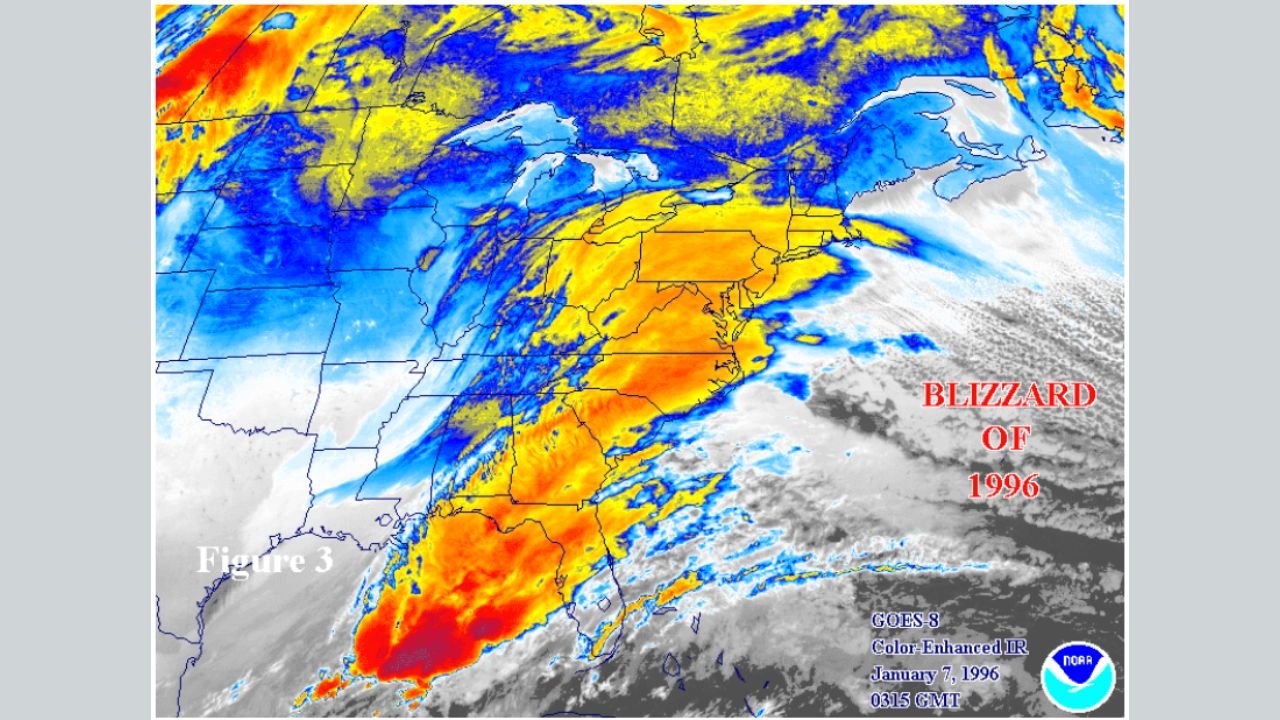
UNITED STATES — This week marks the 30th anniversary of the historic Blizzard of 1996, one of the most destructive and far-reaching winter storms ever recorded in the eastern United States. Satellite imagery and National Weather Service analysis from January 1996 show how a perfectly aligned atmospheric pattern produced crippling snowfall, hurricane-force winds, and widespread travel shutdowns from the Deep South to New England.
The Blizzard of ’96 remains a benchmark storm that meteorologists still reference today when evaluating major East Coast winter threats. The event unfolded between January 6 and January 8, 1996, impacting more than 20 states and leaving millions stranded.
A Rare and Explosive Storm Setup
Satellite data from January 7, 1996, captured a classic but rare configuration: deep Arctic air plunging southward collided with a rapidly intensifying Gulf and Atlantic moisture plume. This clash created a powerful coastal low that strengthened rapidly as it moved northeast.
Cold air was firmly entrenched over the Midwest and Northeast, while a surge of warm, moisture-laden air streamed north from the Gulf of Mexico. The resulting storm intensified explosively, producing widespread heavy snow bands and blizzard conditions along the East Coast.
Snowfall Totals That Redefined Records
Snowfall from the Blizzard of 1996 was extreme and historic:
- Parts of Pennsylvania, New York, Virginia, West Virginia, and Maryland recorded 20 to 30 inches of snow
- Portions of the Mid-Atlantic and Appalachians exceeded 30 inches
- Major cities such as Washington, D.C., Philadelphia, and New York City were buried under paralyzing snow depths
Snow fell rapidly, often exceeding 2 to 3 inches per hour, making road clearing nearly impossible during the height of the storm.
Widespread Impacts Across the Eastern U.S.
The blizzard effectively shut down much of the eastern half of the country. Airports closed for days, highways became impassable, and emergency services were overwhelmed. Thousands of motorists were stranded, and power outages spread as heavy snow and wind brought down trees and power lines.
In some areas, states of emergency were declared, and National Guard units were deployed to assist with rescues and snow removal. Schools and government offices remained closed for extended periods as recovery efforts dragged on.
Why the Blizzard of ’96 Still Matters Today
Meteorologists continue to study the Blizzard of 1996 because it demonstrates how precise timing and atmospheric alignment can turn a winter storm into a historic disaster. The event highlights the importance of cold air placement, storm track, and rapid intensification — factors still monitored closely in modern forecasting.
Satellite imagery from the storm shows an unusually expansive cloud shield and powerful moisture feed, a combination rarely achieved at such scale. These lessons remain relevant today as forecasters compare modern storms to the Blizzard of ’96 when assessing worst-case scenarios.
A Benchmark Winter Storm, 30 Years Later
Three decades later, the Blizzard of 1996 stands as a reminder of how quickly winter weather can escalate from manageable to catastrophic. While forecasting technology has improved dramatically since then, the storm remains a gold standard example of extreme East Coast winter weather.
As winter continues across the United States, the Blizzard of ’96 serves as both a historical milestone and a cautionary tale — proof that when the atmosphere aligns just right, the impacts can be unforgettable.
For more historical weather analysis, major storm breakdowns, and current forecast coverage, continue following updates from WaldronNews.com.