
California, Oregon, Washington, Nevada, Idaho, Montana, Minnesota, Wisconsin, Michigan, and Pennsylvania Face Multi-Hazard Weather Pattern With Heavy Rain, Snow, Ice, and Fire Risk Through Early Week
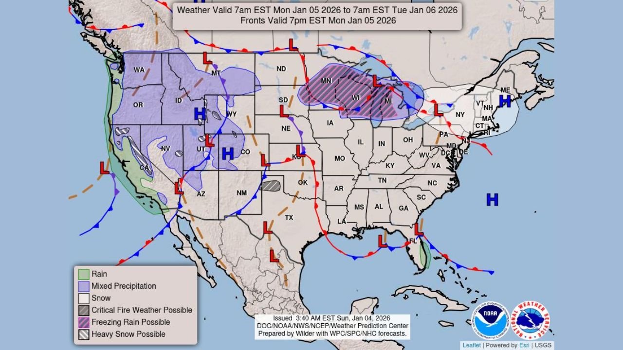
UNITED STATES — A complex and high-impact weather pattern is unfolding across much of the United States, bringing heavy rain to the West Coast, mountain snow across the Intermountain West, a wintry mix in the Upper Midwest and Great Lakes, and critical fire weather conditions across the central and southern High Plains through Monday, according to the latest national forecast data.
West Coast: Pacific Moisture Brings Heavy Rain and Mountain Snow
A strong plume of Pacific moisture continues to move onshore, producing locally heavy rainfall along coastal and lower-elevation areas of California, Oregon, and Washington. Forecast maps show persistent rain bands impacting coastal cities and valleys, increasing the risk of urban flooding, poor drainage issues, and slick road conditions.
At the same time, significant snowfall is expected across higher elevations, including the Sierra Nevada, Cascades, and portions of the Intermountain West, affecting parts of Nevada, Idaho, Montana, Utah, and Wyoming. Snowfall rates in mountain passes may become heavy at times, leading to dangerous travel conditions and potential road closures.
Northern Plains, Upper Midwest, and Great Lakes: Wintry Mix Creates Travel Hazards
Farther east, a developing frontal system is producing a wintry mix of snow, sleet, and freezing rain across portions of the northern Plains, Upper Midwest, and Great Lakes region.
Forecast guidance highlights elevated winter weather impacts across Minnesota, Wisconsin, Michigan, and parts of northern Illinois, where icy road surfaces and reduced visibility may affect travel into early Monday. Some areas near the Great Lakes could see periods of freezing rain, increasing the risk of power outages and hazardous driving conditions.
Central and Southern High Plains: Fire Weather Risk Increases
While much of the country deals with precipitation, dry and gusty winds are creating a separate hazard across the south-central and central High Plains, including parts of Colorado, Kansas, Oklahoma, Texas, and New Mexico.
Low humidity combined with strong winds is leading to elevated to critical fire weather conditions, especially in areas with dormant vegetation. Any fires that develop could spread rapidly, prompting heightened concern for local fire agencies.
Northeast and Mid-Atlantic: Mixed Impacts Ahead
As the system progresses eastward, parts of Pennsylvania and surrounding Mid-Atlantic states may experience rain changing to snow or a brief wintry mix, depending on timing and temperature trends. While impacts are expected to be more limited compared to the Midwest, slippery roads and reduced visibility remain possible.
What to Watch Next
Meteorologists are monitoring how quickly this system exits the West and how efficiently cold air filters south and east. Small shifts in temperature or storm track could significantly change snowfall and icing totals, particularly in the Midwest and Great Lakes region.
Residents across impacted areas are urged to monitor local forecasts, prepare for changing travel conditions, and follow any advisories or warnings issued by local authorities.
Stay informed and weather-ready — and for continued updates, local impacts, and developing forecasts, keep following WaldronNews.com.