
Central Maryland and Southern Pennsylvania Could See Sudden Snow Squalls Sunday Afternoon as Strong Winds and Brief Whiteouts Develop
MID-ATLANTIC — A burst of fast-moving winter weather is expected Sunday afternoon across central Maryland and southern Pennsylvania, where snow squalls may develop as colder air surges back into the region, forecasters say. While this will not be a long-duration snowstorm, the setup favors brief but intense snow showers capable of rapidly reducing visibility and creating hazardous travel conditions.
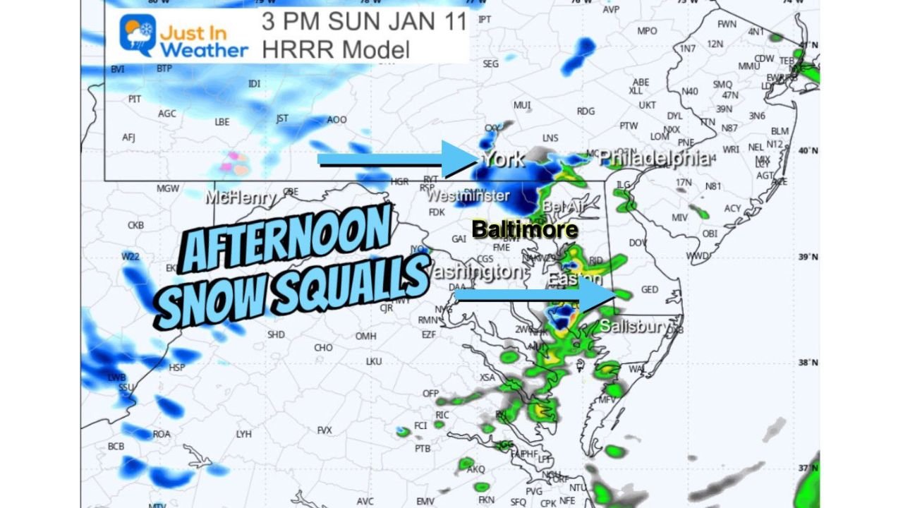
Forecast guidance indicates the highest risk window runs between 1 p.m. and 5 p.m. Sunday, particularly for areas east of the mountains, including parts of central Maryland, southern Pennsylvania, and nearby corridors.
What Is Expected Sunday Afternoon
As colder, gusty northwest winds push into the region, narrow bands of snow squalls may form and move quickly from west to east. These squalls can produce heavy snow rates for short periods, even when overall snowfall totals remain low.
Forecasters say some squalls could:
- Begin as rain or a rain-snow mix
- Transition quickly to heavy snow
- Include graupel or ice pellets
- Produce isolated thunder-snow
Because of their sudden nature, snow squalls often catch drivers off guard.
Travel Impacts Could Be Significant but Brief
Although accumulations are expected to be limited, the primary concern is rapid visibility loss, especially on highways. Within minutes, conditions can shift from wet pavement to snow-covered roads, increasing the risk of accidents.
Drivers traveling Sunday afternoon should be prepared for:
- Sudden whiteout conditions
- Rapid drops in visibility
- Quick icing on untreated roads
- Strong crosswinds during squalls
Strong Winds Add to the Hazard
Winds will be a major factor throughout the day. Gusts of 30 to 40 mph are expected across much of central Maryland and southern Pennsylvania, with even stronger winds west of the mountains.
A Wind Advisory remains in effect for western Maryland and parts of West Virginia, where gusts could reach up to 55 mph. These winds may contribute to blowing snow, falling tree limbs, and isolated power issues.
Who Is Most Likely to Be Affected
Areas most likely to see snow squalls include:
- Central Maryland
- Southern Pennsylvania
- Locations east of the Appalachian ridges
- High-traffic corridors during the afternoon hours
Not every location will see a squall, but any area that does could experience short-lived but dangerous conditions.
What Residents Should Know
Officials emphasize that snow squalls are high-impact, low-duration events. Even a few minutes of heavy snow can be enough to create dangerous travel conditions.
Residents are advised to:
- Stay alert for rapid weather changes
- Slow down immediately if visibility drops
- Allow extra travel time Sunday afternoon
- Monitor local alerts and updates
This setup serves as a reminder that winter hazards don’t always come from major storms. Short-lived events like snow squalls can be just as dangerous when paired with strong winds and cold air.
Stay with Waldron News for continued updates as conditions evolve across Maryland and Pennsylvania.