
Colorado & Wyoming Windstorm Turns Extreme: 95 MPH Gusts Slam Fort Collins–Cheyenne Corridor While Denver and Boulder Foothills Battle Powerful Mountain Wave Winds
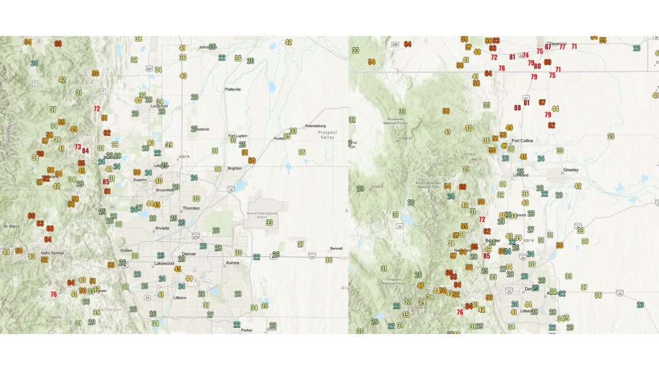
COLORADO — A powerful and potentially historic wind event is unfolding across northern Colorado and southern Wyoming as intense mountain wave winds push across the Front Range. Meteorological observations show extreme gusts between Fort Collins, Colorado, and Cheyenne, Wyoming, where wind speeds have surged into the 75 to 95 mph range, creating hazardous conditions across highways, foothill communities, and open plains.
The event is being driven by a classic mountain wave windstorm, a phenomenon that often develops along Colorado’s Front Range when strong winds descend from the Rocky Mountains and accelerate toward lower elevations.
Fort Collins to Cheyenne Corridor Seeing Extreme Gusts
Wind sensors across northern Colorado and southern Wyoming indicate some of the most intense gusts in the region centered along the Fort Collins–Cheyenne corridor, where red-flag level readings have reached near 90 mph and locally approaching 95 mph.
Areas north of Fort Collins and toward Cheyenne show numerous stations reporting 70 to 80+ mph gusts, highlighting how concentrated the strongest winds are along the immediate foothills and northern plains.
These winds are strong enough to:
- Blow over high-profile vehicles on exposed highways
- Cause scattered power outages
- Down tree limbs and weak structures
- Produce dangerous crosswinds on open roads
Travel between Colorado and Wyoming along Interstate 25 could become especially hazardous if the strongest gusts continue.
Boulder Foothills and Highway 93 Hit by 60–85 MPH Winds
The maps also reveal intense wind readings in the Boulder foothills, particularly near the Highway 93 corridor and the NCAR area, which are well-known hotspots during mountain wave wind events.
Stations in these locations are reporting gusts between 60 and 85 mph, indicating that powerful downslope winds are spilling out of the mountains and accelerating into nearby valleys.
Communities around:
- Boulder
- Superior
- Louisville
- Golden foothills
are seeing some of the strongest winds outside the northern corridor.
Because the winds descend rapidly off the mountains, gusts can increase dramatically within just a few miles, meaning conditions may vary significantly across the metro region.
Denver Metro Experiencing Widespread 25–50 MPH Gusts
While the most extreme winds are concentrated near the foothills, the broader Denver–Boulder metro region is also experiencing widespread strong gusts.
Weather stations across Denver, Aurora, Arvada, Lakewood, Thornton, and Broomfield show winds generally ranging between 25 and 50 mph, with occasional stronger bursts pushing above those levels.
Even these lower speeds can still cause:
- Blowing debris
- Difficult driving conditions
- Elevated fire danger in dry areas
The strong gradient between the mountains and the plains is helping maintain these winds across the urban corridor.
Why This Windstorm Is So Intense
Meteorologists say the event is being fueled by a mountain wave wind setup, which occurs when strong winds at higher elevations flow over the Rocky Mountains and descend rapidly on the eastern slopes.
As the air rushes downhill, it compresses and accelerates, producing extremely powerful gusts along the foothills and adjacent plains.
The pattern typically creates three zones of wind intensity:
- Extreme gusts in foothill and mountain wave zones (60–95+ mph)
- Moderate to strong winds along the I-25 corridor (30–60 mph)
- Weaker but still breezy conditions farther east
Current observations across northern Colorado match this pattern almost perfectly.
Areas Seeing the Strongest Observed Winds
Based on the data shown in the wind maps, some of the strongest gust zones include:
- Fort Collins area – gusts approaching 80–90 mph
- Cheyenne corridor – peaks near 95 mph
- Boulder foothills – 60–85 mph gusts
- Highway 93 / NCAR area – repeated strong bursts
- Rocky Mountain foothill towns west of Boulder and Denver
Meanwhile, locations farther east toward Greeley, Brighton, and the eastern plains are generally seeing lighter winds compared to the foothills.
Dangerous Driving Conditions Possible
High winds of this magnitude can be extremely dangerous for vehicles, particularly:
- Semi-trucks and trailers
- RVs and campers
- High-profile vehicles
Drivers traveling along Interstate 25, Highway 93, and other foothill routes should remain alert for sudden gusts capable of pushing vehicles across lanes.
Blowing dust and debris can also reduce visibility in open areas.
Winds Could Continue Through the Day
Mountain wave windstorms can last several hours depending on atmospheric conditions, and the current setup suggests that periods of strong gusts may continue across the Front Range as the pressure gradient remains strong.
Forecasters will continue monitoring conditions closely, especially in the Fort Collins, Boulder, and Denver foothill regions, where the strongest winds tend to persist the longest during these events.
Residents across northern Colorado should secure outdoor items, remain cautious while driving, and stay aware of changing conditions as this historic wind event unfolds across the region.
Stay with WaldronNews for the latest weather developments and severe wind updates across the United States.