
Crystal River, Florida Watched Temperatures Plunge 11 Degrees in Minutes as a Massive Shelf Cloud Swept in From the Gulf on May 2
CRYSTAL RIVER, Florida — A dramatic and visually stunning shelf cloud rolled in from the Gulf of Mexico across most of Florida on May 2, 2026, dropping temperatures by more than 10 degrees in a matter of minutes as it passed over Crystal River. Camera footage captured the moment the storm’s leading edge arrived, showing the sky transform from calm to ominous within seconds as the massive cloud structure swept onshore.
What Happened and How Fast It Hit
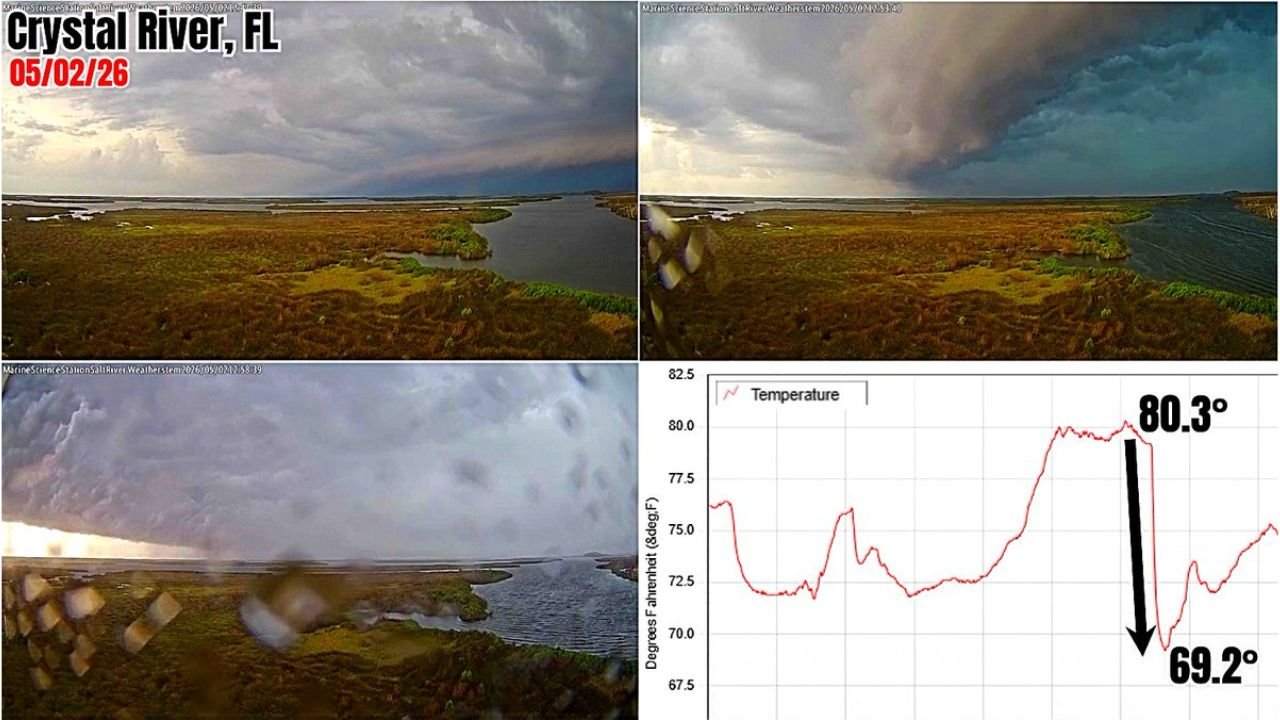
The event was captured live by a weather camera stationed at Crystal River, Florida, showing three distinct stages of the shelf cloud’s arrival in rapid succession.
The temperature data tells the full story of how sudden and dramatic the change was:
- Before the shelf cloud: Temperature sitting at 80.3 degrees Fahrenheit
- After the shelf cloud passed: Temperature dropped to 69.2 degrees Fahrenheit
- Total drop: 11.1 degrees in an extremely short window
That kind of temperature crash in minutes is a hallmark of a powerful outflow boundary, the wall of cold air that a strong storm system pushes ahead of itself as it moves onshore.
What a Shelf Cloud Actually Is
A shelf cloud is a low, horizontal wedge-shaped cloud that forms along the leading edge of a storm’s outflow. It is attached to the base of the parent storm and marks the boundary where cold, sinking air from the storm collides with warm, humid surface air.
When a shelf cloud this large arrives from the Gulf of Mexico, it signals:
- A strong and organized storm system moving onshore
- A sharp and sudden wind shift at the surface
- Rapid temperature drops of 10 degrees or more within minutes
- Possible heavy rain, gusty winds and frequent lightning immediately behind the cloud
Why This Was Unusual for Crystal River
Crystal River sits along Florida’s Nature Coast on the Gulf side, making it directly exposed to any storm systems pushing onshore from the west. While sea breeze storms are common in Florida, a shelf cloud of this scale sweeping across most of Florida from the Gulf simultaneously is a more organized and significant event than a typical afternoon thunderstorm.
The description of the cloud as a mothership by those who witnessed it reflects just how visually overwhelming the structure appeared from the ground, with the shelf cloud dominating the entire sky as it moved inland.
What Residents Along the Gulf Coast Should Know
- Shelf clouds themselves are not tornadoes and are not directly dangerous, but they are a reliable visual signal that severe weather is immediately behind them
- A temperature drop of 10 or more degrees at the surface within minutes means a strong outflow boundary has arrived and gusty, damaging winds are possible
- Anyone along Florida’s Gulf Coast who sees a shelf cloud approaching should move indoors immediately and not wait for rain to begin before taking shelter
WaldronNews.com will continue tracking storm activity along Florida’s Gulf Coast and will provide updates on any developing weather threats across the region.