
Dangerous Ice Storm Unfolds Across Northern New England as Freezing Rain Builds Rapid Ice Accretion Overnight
NORTHERN NEW ENGLAND — A dangerous ice storm is underway across large portions of northern New England early Monday, with freezing rain producing rapid ice accretion that could exceed 0.06 inches per hour, creating hazardous travel conditions, downed trees, and the risk of widespread power outages.
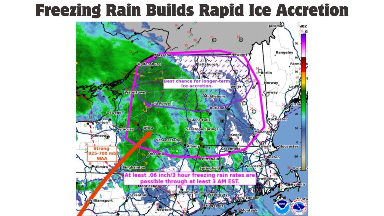
According to the latest mesoscale analysis, persistent freezing rain is impacting parts of northern New York, Vermont, New Hampshire, and western Maine, where surface temperatures remain below freezing while moisture continues to stream northward.
Meteorologists warn this is a high-impact ice event, especially in areas highlighted for longer-duration freezing rain.
Freezing Rain Intensifies With Significant Ice Accumulation Expected
Radar and surface observations show steady bands of freezing rain moving across the region, with ice accretion rates capable of producing at least 0.06 inches of glaze every three hours, and locally higher amounts where precipitation remains persistent.
Forecasters indicate the greatest risk for prolonged icing includes:
- Northern and central Vermont
- Northern New Hampshire
- Portions of northern New York
- Adjacent areas of western Maine
This type of accretion is sufficient to snap tree limbs, weigh down power lines, and create extremely slick road conditions.
Why This Ice Storm Is Especially Dangerous
This event is being driven by a strong low-level warm air advection pattern, with warmer air aloft overrunning sub-freezing air at the surface. This setup allows rain to fall as liquid, then instantly freeze on contact with roads, trees, and infrastructure.
Because freezing rain is continuous rather than intermittent, impacts will escalate quickly:
- Roads may appear wet but are actually ice-covered
- Bridges and overpasses will freeze first
- Emergency response times may increase due to impassable conditions
Power Outages and Tree Damage Possible
With ice continuing to accumulate, power outages are increasingly likely, particularly in wooded and higher-elevation areas. Even relatively small additional ice amounts can dramatically increase stress on trees and lines already coated with ice.
Residents are urged to prepare for possible power disruptions, including having flashlights, backup heat sources, and fully charged devices.
Travel Strongly Discouraged Overnight and Early Morning
Officials are urging people to avoid non-essential travel, especially overnight and during the early morning hours when icing will be hardest to detect.
If travel is unavoidable:
- Drive slowly and leave extra stopping distance
- Avoid sudden braking or sharp turns
- Be alert for falling branches and downed lines
When Conditions May Improve
Freezing rain is expected to continue through the overnight hours into early Monday morning, with gradual improvement possible later in the day as temperatures rise or precipitation changes type. However, lingering ice on untreated surfaces may persist even after precipitation ends.
What You Can Do Now
- Stay indoors if possible
- Avoid driving until conditions improve
- Keep phones charged and emergency supplies ready
- Monitor local weather alerts and power updates
What are conditions like in your area right now?
Have you seen ice buildup, power issues, or dangerous roads where you live? Share your experience and stay updated with the latest severe weather coverage at WaldronNews.com.