
Florida Braces for Significant Cold Snap as Arctic Air Pushes Freezing Temperatures Into Central Florida and Chilly 30s Reach Miami by January 16
FLORIDA — A significant cold snap is increasingly likely to impact Florida beginning Friday morning, January 16, as a surge of Arctic air drives unseasonably cold temperatures deep into the Southeast. Forecast guidance shows widespread freezing conditions pushing into Central Florida, with much colder-than-normal air expected to linger through next weekend.
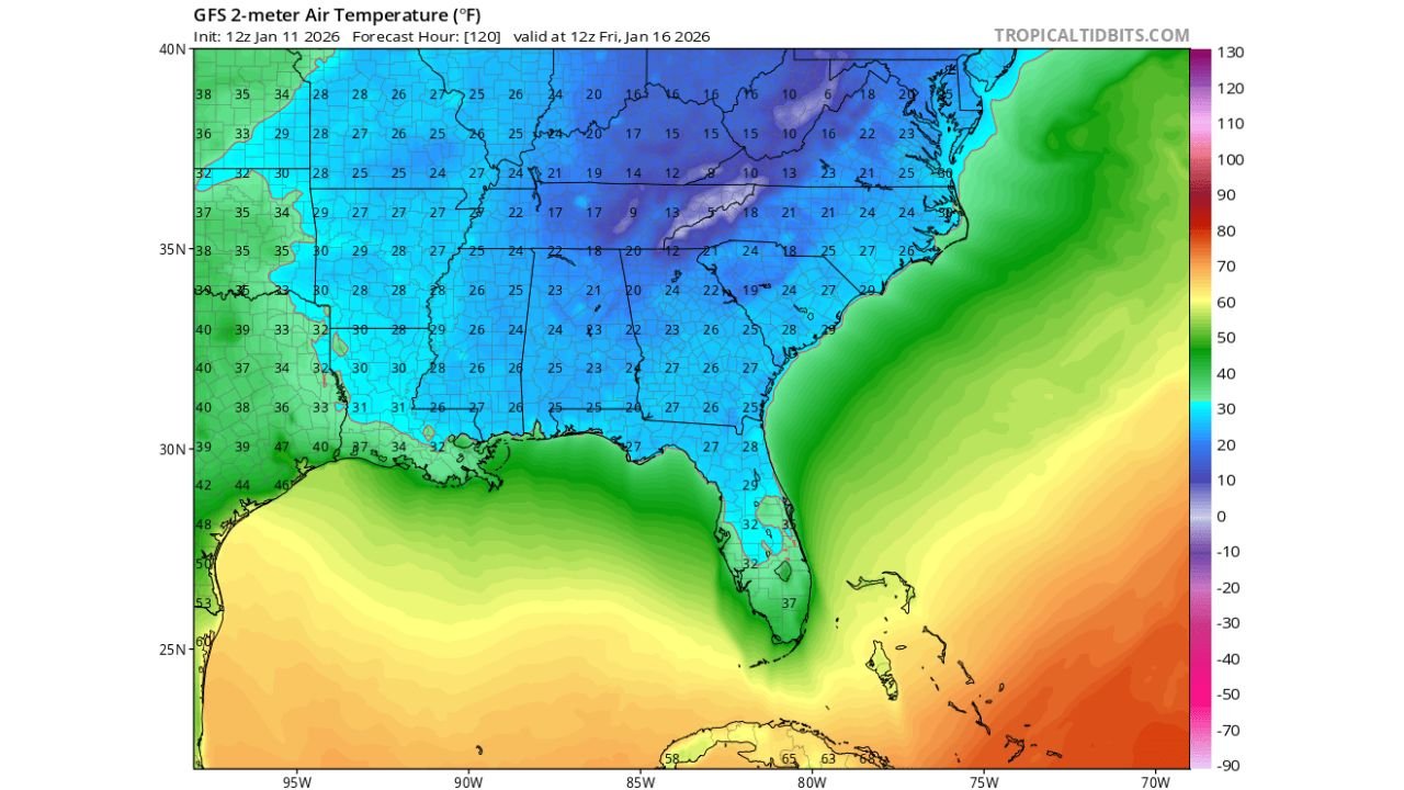
What Forecast Models Are Showing
Multiple forecast models indicate a strong southward push of cold air behind a deep eastern U.S. trough. Temperature projections show:
- Widespread freezing temperatures across North and Central Florida
- Upper 30s to lower 40s possible as far south as South Florida, including the Miami metro area
- A sharp temperature gradient between Florida and the surrounding warm Atlantic waters
The GFS temperature guidance highlights how unusual this setup is, with sub-freezing air covering much of the Southeast while Florida experiences one of its coldest air masses of the season.
NOAA Outlook Confirms Much Colder Than Normal Pattern
The NOAA 6–10 Day Temperature Outlook, valid January 16–20, places Florida firmly within a below-normal temperature zone, signaling high confidence in the cold pattern. This means daytime highs and nighttime lows are expected to remain well below seasonal averages for several days, not just one overnight period.
This type of sustained cold increases the risk of:
- Agricultural impacts
- Pipe freezes in northern and interior areas
- Cold stress for sensitive plants, pets, and outdoor infrastructure
Where the Cold Will Be Felt the Most
- North Florida: Hard freezes likely, especially away from the immediate coast
- Central Florida: Widespread frost and freezing temperatures possible during overnight and early morning hours
- South Florida: Chilly conditions with lows in the upper 30s to lower 40s, which is cold by local standards
Coastal areas may avoid the coldest readings due to onshore flow, but inland locations remain vulnerable.
Why This Cold Snap Is Notable
Florida cold events of this magnitude require:
- A strong Arctic air source
- A deep eastern U.S. trough
- Limited moderation from cloud cover or strong winds
All three ingredients appear to be aligning, making this one of the more significant cold intrusions of the winter season for the state.
How Long Will the Cold Last?
Current guidance suggests the cold pattern will persist through at least the following weekend, with slow moderation thereafter. Overnight lows will remain the primary concern, particularly during the early morning hours when radiational cooling is strongest.
Bottom Line
A significant cold snap is increasingly likely across Florida starting Friday morning, January 16, with freezing temperatures reaching into Central Florida and unusually cold air spreading as far south as Miami. NOAA outlooks strongly support a prolonged colder-than-normal stretch, making this a high-impact event for residents, agriculture, and infrastructure.
Residents should begin preparing now by protecting sensitive plants, checking heating systems, and staying informed as updated forecasts refine the coldest locations and durations.
For continued Florida weather coverage and timely cold-weather updates, stay connected with Waldron News and share how temperatures are dropping in your area.