
Great Lakes Ice Coverage Lags Behind Normal in Early January 2026 as Mild Start to Winter Slows Freeze Across Michigan, Ohio, New York, and Ontario
WALDRON, AR — Ice coverage across the Great Lakes remains below long-term January averages as of January 7, 2026, reflecting a slow and uneven start to winter across the Upper Midwest and Great Lakes region. New data shows that while some lakes are beginning to ice over, overall coverage is still trailing historical norms due to persistent mild air patterns and limited sustained cold outbreaks so far this season.
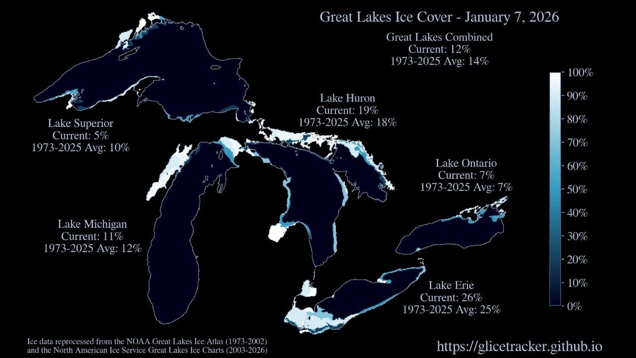
According to the latest ice analysis, combined ice coverage across all five Great Lakes stands at 12%, which is below the long-term January average of 14%. The numbers highlight sharp contrasts between individual lakes, with some freezing faster than expected and others lagging significantly.
Lake-by-Lake Ice Conditions as of January 7, 2026
- Lake Superior (Michigan, Minnesota, Wisconsin)
Ice coverage: 5%
Long-term average: 10%
Lake Superior remains well below normal, with open water dominating much of the lake. The lack of prolonged Arctic air has delayed ice formation across its vast surface. - Lake Michigan (Michigan, Wisconsin, Illinois, Indiana)
Ice coverage: 11%
Long-term average: 12%
Ice development is close to average but still slightly behind, mainly confined to bays and nearshore areas. - Lake Huron (Michigan, Ontario)
Ice coverage: 19%
Long-term average: 18%
Lake Huron is the only lake currently slightly above normal, with more consistent ice growth in northern sections and connecting channels. - Lake Erie (Ohio, Pennsylvania, New York, Ontario)
Ice coverage: 26%
Long-term average: 25%
Lake Erie continues to lead the Great Lakes in ice coverage, which is typical due to its shallower depth and faster response to cold air. - Lake Ontario (New York, Ontario)
Ice coverage: 7%
Long-term average: 7%
Ice coverage on Lake Ontario remains right at average, mostly limited to sheltered bays and shoreline zones.
Why Ice Growth Is Lagging This Winter
Meteorologists point to a mild early-winter temperature pattern across much of the central and eastern United States as the primary reason ice coverage remains subdued. Frequent intrusions of warmer air and limited Arctic outbreaks have prevented lakes—especially Lake Superior—from locking into sustained freezing conditions.
In addition, strong winds and active storm systems have periodically broken up forming ice, further slowing accumulation.
Why Great Lakes Ice Matters
Ice coverage on the Great Lakes plays a critical role in:
- Regulating winter lake-effect snow
- Protecting shorelines from erosion
- Supporting regional ecosystems
- Influencing spring water temperatures
Lower ice coverage often allows more heat and moisture to escape into the atmosphere, which can fuel stronger lake-effect snow events later in the season if colder air eventually arrives.
What to Watch Going Forward
Forecasters will be closely monitoring whether colder air masses move into the Great Lakes region later in January, which could allow ice coverage to rapidly increase—particularly on Lake Superior and Lake Michigan. Historically, significant ice growth can still occur later in winter if sustained cold sets in.
For now, the Great Lakes remain in a below-normal ice pattern, a notable signal of how winter 2025–26 has started across the region.
Stay informed with the latest regional weather and climate updates. Share your thoughts on how winter is shaping up where you live and follow ongoing coverage at WaldronNews.com.