
Heavy Rain Brings Much Needed Soil Moisture Relief to Nebraska and Kansas as Central Plains Drought Conditions Begin to Ease Around Lincoln, Omaha and Topeka
KANSAS CITY, Missouri — After months of sitting well below normal soil moisture levels, the Central Plains is finally catching a break — heavy rain that fell Saturday, April 11 across a corridor stretching from Lincoln and Omaha, Nebraska south through Topeka, Kansas is beginning to chip away at what has been a persistently dry and stressed agricultural landscape across the region, according to soil moisture data from BAM Weather (BAMWX.COM).
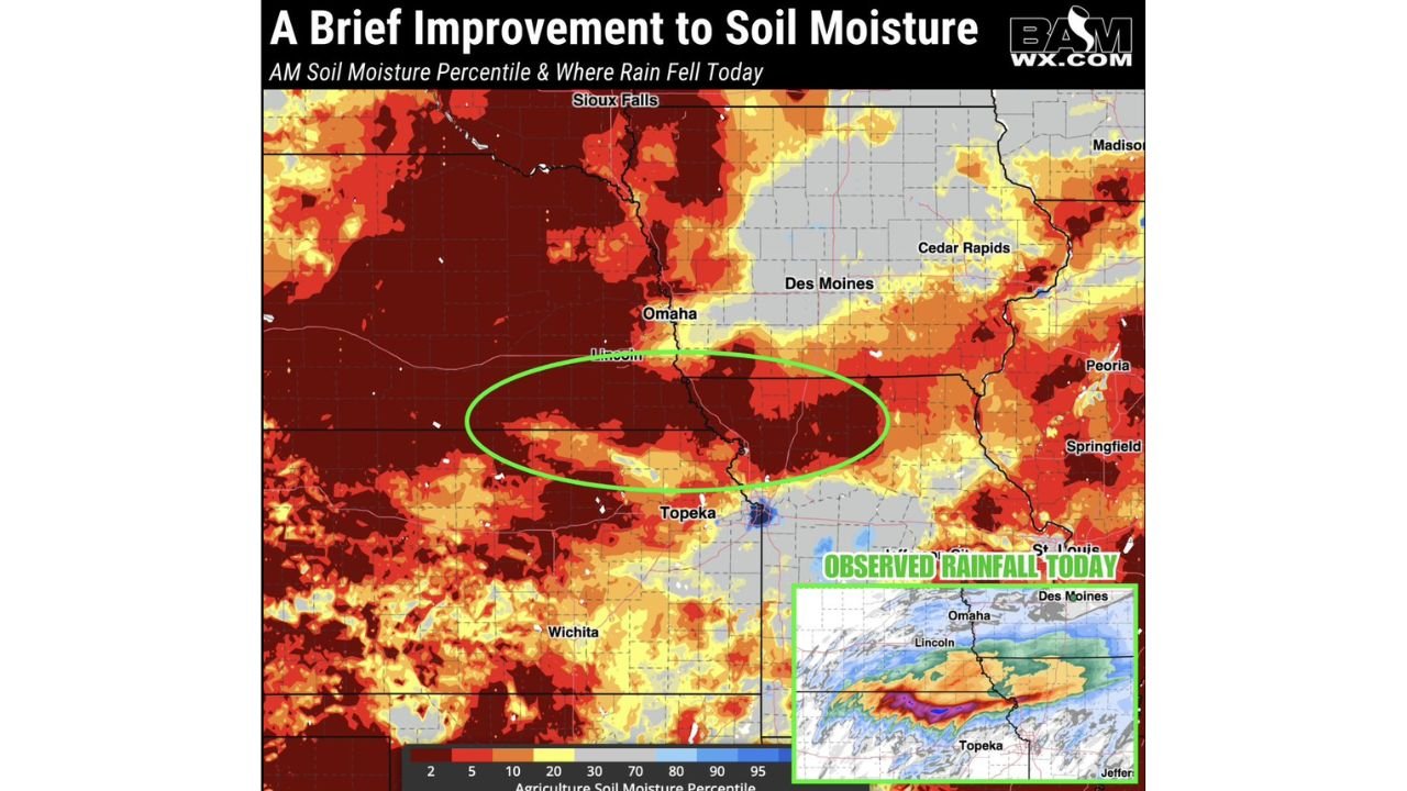
The improvement is welcome but comes with important context — the broader Central Plains remains deeply in the red, with soil moisture percentiles across large stretches of Nebraska, Kansas, Iowa, and Missouri still running at historically low levels. Saturday’s rainfall is a start, but the work of recovering from a serious moisture deficit is far from over.
Where Relief Is Being Felt
The green-circled zone on the BAM Weather soil moisture map tells the story clearly — the area most directly benefiting from Saturday’s observed rainfall runs roughly from Lincoln and Omaha in southeast Nebraska down through Topeka, Kansas, capturing portions of the Kansas-Nebraska border region that had been among the driest in the entire Central Plains:
- Nebraska: Lincoln and Omaha are at the center of today’s rainfall footprint and stand to see the most immediate soil moisture improvement
- Kansas: Topeka and surrounding northeast Kansas communities received measurable rainfall that should begin shifting local soil moisture readings
- Iowa: Des Moines and the southern Iowa corridor saw rainfall on the edges of today’s system
- Missouri: St. Louis and the broader Missouri River valley sit on the eastern fringe of observed precipitation today
Meanwhile, vast areas of western Nebraska, western Kansas, and the surrounding High Plains remain deeply stressed — the dark red and orange tones dominating the BAM Weather map show soil moisture percentiles sitting at 10% or below across enormous stretches of the region, meaning soils there are drier than 90% of historical records for this time of year.
What This Rain Actually Means for Farmers and Communities
Soil moisture is not just a weather statistic — it is the foundation of agricultural productivity across one of the most important farming regions in the United States. Nebraska and Kansas together produce enormous quantities of wheat, corn, sorghum, and soybeans, and when soil moisture percentiles drop into the single digits as they have across much of the Central Plains this season, crop emergence, root development, and early-season yield potential all suffer significantly.
Saturday’s rainfall will not erase the deficit overnight. Soil moisture recovery from deeply depleted levels typically requires multiple significant rain events spread over weeks, not a single day of precipitation. However, every inch matters, and the improvement that will be reflected in Sunday’s soil moisture data represents genuine progress for farmers in the Lincoln, Omaha, and Topeka corridor who have been watching their fields dry out through the early spring season.
The BAM Weather analysis puts it plainly — the shift from Saturday’s rain should be reflected in tomorrow’s data, giving agricultural communities their first measurable sign of improvement after a prolonged dry stretch.
More Rain Possible Through the Week
The moisture story does not end with Saturday. Further rain and storm risks through the coming week could add additional improvements to soil moisture across portions of the Central Plains that received little to nothing from Saturday’s system. The same storm pattern driving severe weather risks across the region through Sunday and into Monday also carries the potential for additional rainfall accumulation in areas that need it most.
However, residents and farmers across the broader Central Plains should temper expectations — the deep red zones covering western Nebraska, western Kansas, and the surrounding High Plains are unlikely to see meaningful recovery from a single week of storm activity. The moisture deficit in those areas has been building for months and will require a sustained pattern change to fully recover.
What to Watch Through the Week
- Sunday’s updated soil moisture maps will show exactly how much improvement Saturday’s rainfall delivered across the Lincoln, Omaha, and Topeka corridor
- Additional storm systems tracking through the Central Plains Monday and beyond could bring further rainfall to areas still sitting in critically dry conditions
- Farmers across western Nebraska and western Kansas — where soil moisture remains at historic lows — should continue monitoring weekly precipitation forecasts closely as planting season approaches
- The contrast between the improving southeast Nebraska corridor and the still-depleted western Plains will sharpen through the week as new rainfall data is collected
- Any additional significant rainfall across the Kansas City to Omaha corridor this week would push soil moisture recovery into genuinely meaningful territory for the upcoming growing season
Saturday’s rain is a step in the right direction for the Central Plains — but with soil moisture still critically below normal across the majority of Nebraska and Kansas, the region needs more, and the week ahead will determine whether this is the beginning of a real recovery or just a brief pause in what has been a difficult dry stretch for one of America’s most important agricultural regions.
WaldronNews.com will continue tracking soil moisture recovery and rainfall totals across Nebraska, Kansas, Iowa, and Missouri and will provide updates as new data becomes available through the week.