
Idaho Mountains Brace for Significant Snowfall as National Weather Service Forecasts 10–20 Inches at Higher Elevations Late Tuesday Through Wednesday
IDAHO — A developing winter weather system is expected to bring increasing snowfall to Idaho’s mountain regions late Tuesday through Wednesday, with the heaviest impacts focused on higher elevations where snow totals could reach 10 to 20 inches, according to forecast guidance from the National Weather Service.
Forecast data shows light snow developing overnight into Tuesday morning, followed by a notable intensification Tuesday afternoon that continues through Wednesday evening. While valley locations will see lighter accumulations, conditions in the mountains are expected to deteriorate rapidly as snowfall rates increase and winds strengthen.
Snowfall Timeline: Light Snow First, Then Heavier Bands
Meteorologists indicate that light snow will persist through Tuesday morning, mainly producing minor accumulations. The more impactful phase of this system arrives Tuesday afternoon, when moderate to occasionally heavy snow spreads across central and northern Idaho’s mountain zones.
Snow is expected to continue into Wednesday evening, particularly along higher terrain corridors. The prolonged nature of this event means accumulations will steadily build over time, increasing travel and safety concerns.
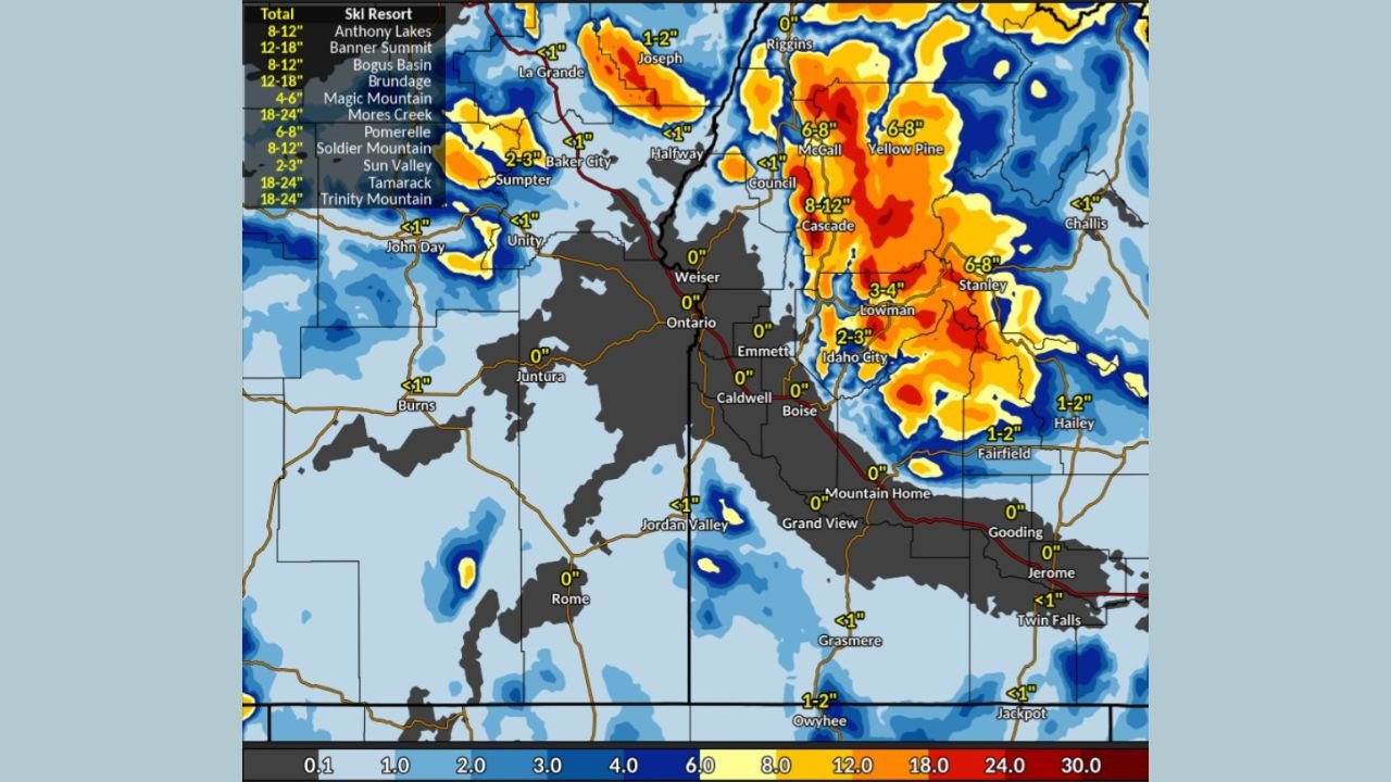
Expected Snow Totals by Elevation
Snowfall projections show a clear elevation-dependent impact:
- 3 to 10 inches of snow expected in mountain valleys
- 10 to 20 inches of snow forecast above 6,000 feet
The highest totals are likely in the central Idaho mountains, where persistent snowfall bands and colder temperatures will allow snow to accumulate efficiently through the event.
Gusty Winds to Cause Blowing and Drifting Snow
In addition to accumulating snow, gusty winds are expected to develop during the heaviest snowfall period. These winds will lead to localized blowing and drifting snow, significantly reducing visibility at times, especially on exposed ridgelines and mountain passes.
Blowing snow may also create uneven road conditions, with rapidly changing visibility making driving particularly hazardous even where snowfall totals are not extreme.
Difficult Travel Expected in Mountain Areas
The combination of steady snowfall, wind, and cold temperatures will result in difficult winter driving conditions across Idaho’s mountain regions. Mountain passes, higher-elevation highways, and routes near ski areas are most likely to be affected from Tuesday afternoon through Wednesday night.
Travel delays, slick roads, and temporary closures are possible, especially during periods of heavier snow. Drivers are urged to plan ahead, allow extra travel time, and carry winter safety supplies if traveling through mountainous terrain.
What This Means Going Forward
While lower elevations may see limited impacts, this system marks a significant midweek winter weather event for Idaho’s mountains, reinforcing the importance of elevation-specific forecasts. Conditions are expected to gradually improve late Wednesday night into Thursday as snowfall tapers off.
Residents and travelers should continue monitoring updated forecasts and be prepared for rapidly changing conditions in mountain areas.
For continued weather updates, local impact analysis, and developing forecasts, follow coverage from WaldronNews.com.