
Idaho, Oregon, and Montana Brace for Moderate Mountain Snow Through Thursday as Showers Bring Highly Variable Totals
IDAHO — A Pacific storm system is moving across the Inland Northwest this week, bringing moderate mountain snowfall to parts of Idaho, eastern Oregon, and western Montana through Thursday, with the most impactful snow focused on higher elevations and ski areas. Forecast data shows that snow totals will vary sharply over short distances due to the showery nature of the system, making localized impacts more significant than broad regional averages.
Based on National Weather Service guidance, snow showers are expected to increase Tuesday night and continue through Wednesday and early Thursday, particularly across central and north-central Idaho, including the West Central Mountains, Salmon River Range, and Sawtooth region. Radar imagery shows bands of precipitation repeatedly developing and moving through the same areas, which could lead to brief periods of heavier snowfall despite relatively modest storm-wide totals.
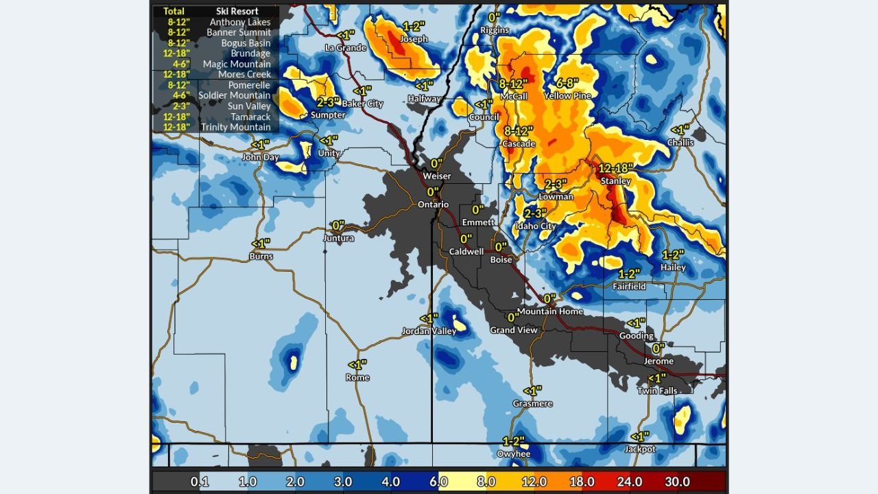
Mountain Snow Totals Show Sharp Variability
Forecast snowfall maps indicate that valley locations such as Boise, Caldwell, Emmett, and the Treasure Valley are likely to see little to no accumulation, with temperatures remaining marginal for snow. In contrast, higher elevations will see notable accumulations, especially where snow showers persist the longest.
Projected totals include:
- 8 to 12 inches in favored mountain zones near McCall, Cascade, and Council
- 12 to 18 inches in localized higher terrain near Stanley and the Sawtooth Mountains
- 6 to 8 inches across portions of the Payette and Boise National Forests
- Lower totals (1–3 inches) possible around Idaho City and Lowman
- Minimal to no accumulation in the Snake River Plain and Treasure Valley
Ski resorts including Bogus Basin, Brundage Mountain, Tamarack, and Sun Valley are expected to benefit from fresh snowfall, though amounts will differ significantly depending on elevation and how long showers persist over each location.
Graupel and Thundersnow Possible Wednesday
Meteorologists note that the atmosphere will remain unstable enough Wednesday afternoon for convective snow showers, meaning brief bursts of heavier snow, graupel, and even isolated thunder cannot be ruled out in the mountains. These bursts may lead to rapid changes in visibility and road conditions, particularly on mountain passes and higher-elevation highways.
Because of this convective setup, snowfall totals will be highly localized, with some areas receiving several inches in a short time while nearby locations see much less.
Travel Impacts Focused on Mountain Routes
While widespread lowland travel disruptions are not expected, mountain travel could become hazardous at times, especially during heavier snow showers. Roads such as Highway 55, Highway 21, and routes near mountain passes may experience slick conditions and reduced visibility, particularly Wednesday afternoon and evening.
Drivers traveling through higher elevations are advised to monitor conditions closely and be prepared for winter driving.
Looking Ahead
Snow showers are expected to gradually diminish late Wednesday night into Thursday as the system moves east. Cooler conditions will linger, but significant additional accumulation is not expected beyond Thursday afternoon.
For Idaho’s mountains, this system will deliver beneficial mid-winter snowfall, though its uneven nature means impacts will depend heavily on location and timing.
Readers can stay updated with additional regional weather coverage at Waldron News, where we continue to track evolving winter conditions across the West.