
Illinois, Indiana, and Missouri See Isolated Severe Storm Risk With Damaging Winds and Brief Tornado Possible
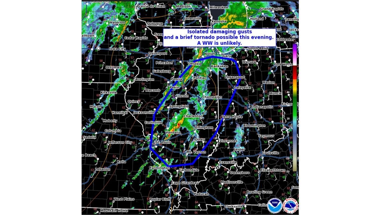
MIDWEST — The Storm Prediction Center (SPC) has issued Mesoscale Discussion #11, highlighting a zone of isolated damaging wind gusts and a brief tornado risk across parts of Illinois, Indiana, and Missouri as a line of thunderstorms continues to move east this evening.
Forecasters say a severe thunderstorm watch is unlikely at this time, but conditions remain sufficient for localized hazards, especially where storms briefly intensify along the advancing line.
States and Areas Most at Risk
The primary corridor of concern stretches from:
- Central and eastern Missouri
- Central and eastern Illinois
- Western and central Indiana
Communities near and between St. Louis, Springfield (IL), Peoria, Champaign, Terre Haute, Lafayette, and Indianapolis may experience the strongest storms as the line progresses.
What the SPC Is Watching
According to the mesoscale analysis:
- Isolated damaging wind gusts are the main threat, with potential gusts strong enough to down trees and power lines.
- A brief tornado cannot be ruled out, particularly where storms interact with local boundaries or briefly strengthen.
- Overall severe coverage is expected to remain spotty, which is why a broader watch has not been issued.
Radar imagery shows a broken but active line of storms, with embedded heavier cores capable of producing short-lived severe weather.
Timing and Storm Movement
- Storms are moving generally east to northeast
- The threat will persist through the late evening hours
- Risk should gradually diminish as storms weaken farther east overnight
Safety Guidance
Residents in the affected areas of Illinois, Indiana, and Missouri should:
- Stay alert for rapid weather changes
- Secure loose outdoor items
- Be prepared to move to interior rooms if warnings are issued
- Monitor local alerts and radar updates closely
Even without a widespread watch, isolated severe storms can still cause damage, especially during evening hours when visibility is reduced.
Weather conditions will continue to be monitored closely as this system moves across the Midwest.