
Illinois, Indiana, Ohio, Pennsylvania, New York, and New England Could See a Winter Storm Signal Between January 14–16 as Southern Jet Strengthens
ILLINOIS — Long-range ensemble guidance is beginning to show a coherent winter storm signal developing across the Midwest and Northeast during the January 14–16 timeframe, though forecast confidence remains moderate given the lead time. Multiple ECMWF ensemble products indicate a pattern shift favoring southern-stream amplification, a feature that has largely been absent for much of the winter so far.
While details remain unresolved, the evolving setup is worth monitoring closely, especially across Illinois, Indiana, Ohio, Pennsylvania, New York, and interior portions of New England, where cold air availability could support snow if the storm track aligns correctly.
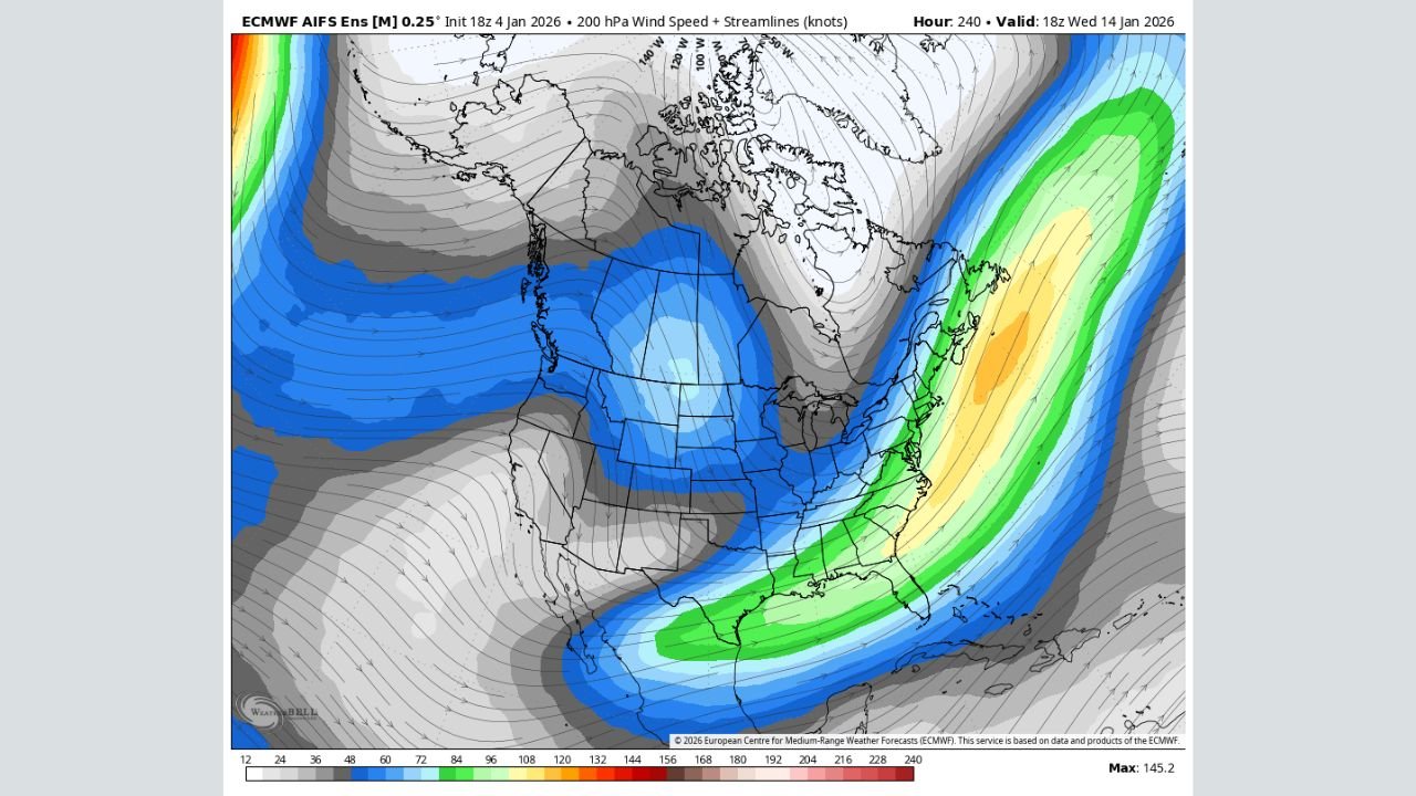
Large-Scale Pattern Shows Southern Jet Finally Amplifying
Upper-air ensemble maps at 500mb show a pronounced western ridge building across the Pacific Coast, while a deep trough develops over the central and eastern United States. This configuration supports a more active southern jet, increasing the likelihood of cyclogenesis somewhere east of the Mississippi River.
At the same time, ensemble wind fields at 200mb show strengthening jet energy diving into the eastern U.S., a key ingredient for storm development. This is notable because southern jet dominance has been largely missing this winter, limiting snow opportunities across the Midwest and Northeast.
January 14–16 Identified as the Most Favorable Window
Across multiple ensemble members, January 14–16 emerges as the most consistent time window for a potential winter system. This does not guarantee a significant storm, but it does indicate pattern support rather than a single outlier solution.
The signal suggests:
- Energy entering from the southern stream
- Cold air already in place across the Midwest and Northeast
- A favorable trough orientation to support surface development
Because this remains 10–12 days out, track, intensity, and precipitation type are still highly uncertain.
Snow Potential Depends on Storm Track and Thermal Profiles
Ensemble snowfall output currently shows light to locally moderate snow probabilities across parts of:
- Northern Illinois
- Indiana and Ohio
- Interior Pennsylvania and New York
- Portions of New England
However, this data should be viewed as a signal of possibility, not a final snowfall forecast. Small shifts in storm track could result in rain, snow, or mixed precipitation, especially closer to the I-95 corridor.
Interior and higher-elevation areas currently have the best signal for wintry impacts, assuming cold air remains entrenched.
Teleconnections Offer Mixed but Improving Support
The East Pacific Oscillation (EPO) is trending toward a negative phase, which typically supports colder air across the central and eastern U.S. Meanwhile, other large-scale signals suggest less northern jet dominance, allowing the southern stream more influence.
This combination is not locked in, but it represents one of the more favorable setups seen so far this season for a Midwest-to-Northeast winter event.
What to Watch Going Forward
Over the next several days, confidence will increase if:
- Southern jet energy continues to appear in successive model runs
- Cold air remains firmly in place ahead of the system
- Ensemble clustering improves around a similar storm track
If these trends hold, forecast messaging may shift from “signal” to “potential impact.”