
Indiana, Illinois, and Ohio Face Lackluster Snow Outlook as Dry Air and Warmer Pattern Limit Accumulations Through Mid-January
INDIANA — A developing weather pattern across the Midwest is shaping up to be disappointing for snow lovers, with Indiana, Illinois, and Ohio expected to see very limited snowfall over the next week as dry air dominates and milder temperatures move in.
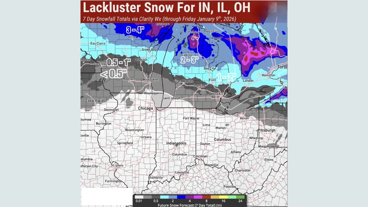
Recent forecast data and snowfall outlook maps show that the core of meaningful snow activity will stay well north, mainly across Wisconsin and Michigan, while much of Indiana, Illinois, and Ohio remain on the southern edge of the storm track.
Snowfall Totals Expected to Stay Minimal
According to the latest 7-day snowfall projections, most of Indiana, Illinois, and Ohio are forecast to receive less than 0.5 inches of snow, if any at all, through the end of the week. Even areas closer to the I-80 corridor may only see light flurries or brief snow showers, with little to no accumulation.
In contrast, parts of northern Wisconsin and Michigan could see 2 to 4 inches of snow, with localized higher totals in lake-enhanced regions. This sharp gradient highlights how dry air pushing southward is suppressing snowfall potential across the central Midwest.
Dry Air Playing a Key Role
Meteorologists point to persistent dry air as the main reason snow systems are weakening as they approach Indiana, Illinois, and Ohio. This dry layer in the atmosphere causes snow to either evaporate before reaching the ground or fall as brief, scattered flurries rather than organized snowfall.
As a result, even when systems pass nearby, snow coverage becomes patchy and unreliable, making widespread accumulation unlikely.
Warmer Temperatures Add to the Problem
Compounding the lack of moisture is a warming trend expected next week, which further reduces the chances of meaningful snow. Forecast temperatures are projected to rise above seasonal averages, especially during the daytime, limiting snow growth and encouraging melting where flakes do manage to fall.
This warmer pattern is expected to persist for several days, reinforcing the idea that significant snow chances are not on the immediate horizon for Indiana, Illinois, or Ohio.
What This Means Going Forward
While winter is far from over, the current setup suggests that snow lovers in Indiana, Illinois, and Ohio may need to wait longer for a more favorable pattern. Forecasters emphasize that long-range winter potential still exists later in the season, but the next 7 to 10 days do not look promising for snow across these states.
For now, residents can expect quiet winter weather, limited travel impacts, and mostly dry conditions — a stark contrast to the heavier snow activity remaining locked farther north.
Stay with Waldron News for continued updates as meteorologists monitor changes in the broader winter pattern and track when colder, more active systems may finally return to the region.