
Indiana, Ohio, Illinois, Kentucky, and Much of the U.S. Brace for Rare January Warm Surge as Winter “Heatwave” Pushes Temperatures 20–30 Degrees Above Normal
UNITED STATES — A remarkable January warm surge is setting up across much of the United States this week, with forecast data showing temperatures running 20 to 30 degrees above normal across large portions of the Midwest, Great Lakes, Ohio Valley, and central U.S. By Friday, parts of Indiana and Ohio could see highs approaching 65 to near 70 degrees, levels more typical of late March or April than mid-winter.
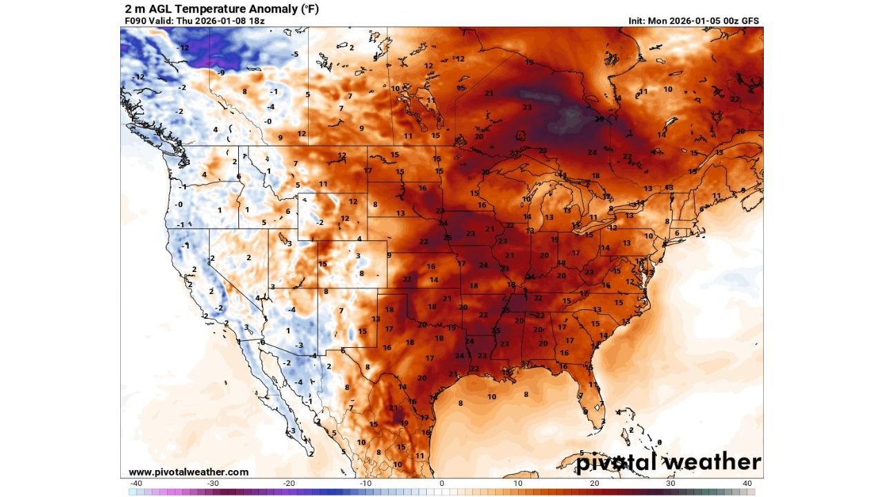
Temperature anomaly maps valid through Thursday, January 8, show deep red shading covering much of the eastern two-thirds of the country, signaling an unusually strong and expansive warm pattern.
Midwest and Ohio Valley See the Most Extreme Warmth
The strongest anomalies are centered over the Midwest and Ohio Valley, including:
- Indiana and Ohio, where daytime highs could surge into the mid to upper 60s, especially in southern and central areas
- Illinois, Kentucky, and Missouri, where temperatures may reach the upper 50s to low 60s
- Michigan, Wisconsin, and Iowa, where readings could still run 15 to 25 degrees above average, despite snowpack in some areas
Forecast guidance shows these regions sitting directly beneath a powerful upper-level ridge, allowing warm air to flow northward from the southern Plains and Gulf region.
Warmth Expands Across the Central and Eastern U.S.
Beyond the Midwest, the warm pattern extends across a broad swath of the country:
- The Central Plains and Mississippi Valley are expected to experience highs well above seasonal norms
- The Southeast will also remain unusually mild, though anomalies there are slightly less extreme than farther north
- Even parts of the Northeast are forecast to run well above average, limiting winter weather potential
This setup creates what forecasters often refer to as a “winter heatwave”—a prolonged period of anomalous warmth during what is typically the coldest part of the year.
Why This Is Happening
The pattern is driven by a strong ridge of high pressure dominating the central and eastern United States. This ridge suppresses cold air intrusions from Canada while allowing mild Pacific and Gulf air to spread northward.
Meanwhile, colder-than-normal air remains largely confined to portions of the western U.S., where blues on the anomaly map indicate below-average temperatures, especially in higher elevations.
Impacts: Snowmelt, Flooding Concerns, and Seasonal Disruption
While many residents may welcome a break from winter cold, the warmth does come with potential downsides:
- Rapid snowmelt in areas with existing snowpack could lead to localized flooding
- Ice cover on rivers and lakes may weaken more quickly than usual
- The warm stretch could disrupt winter recreation and agriculture planning
Despite the springlike feel, forecasters caution that winter is far from over, and colder air could return later in January.
What to Expect Next
Current projections suggest this warm pattern will persist for several days before gradually easing. Long-range guidance continues to monitor whether colder air will attempt to re-enter the central and eastern U.S. later in the month.
For ongoing updates on temperature trends, winter pattern changes, and regional impacts, stay with WaldronNews.com.