
Lake-effect Snow Intensifies Across Central and Western New York as Fulton Area Targets Over 30 Inches Through Monday
NEW YORK — A prolonged lake-effect snow event is underway across central and western New York, with the heaviest snowfall expected east and southeast of Lake Ontario through early Monday morning, according to the latest National Weather Service forecast issued Friday.
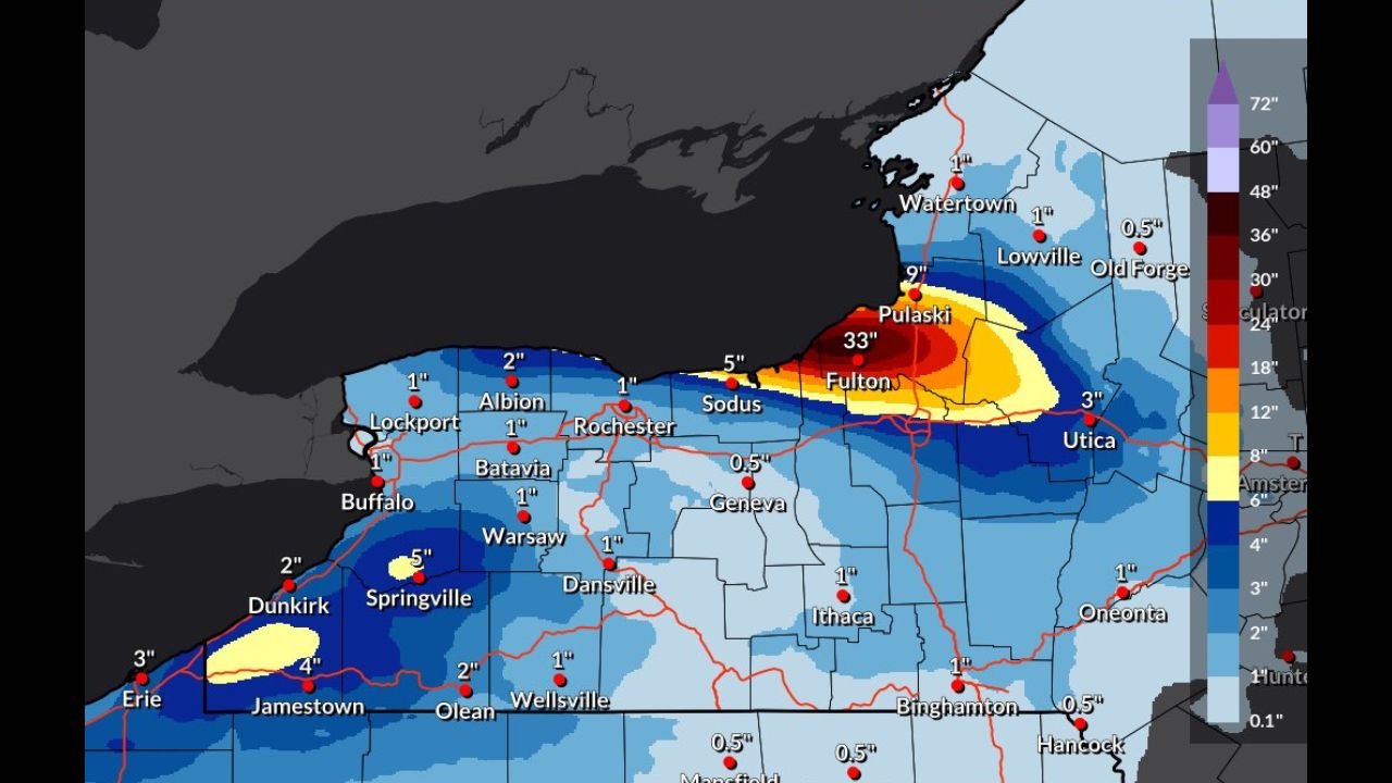
Forecast maps show a dangerous and persistent lake-effect snow band setting up across Oswego County, with the Fulton area directly under the core of the heaviest snowfall. Some locations near and just east of Lake Ontario could see more than 30 inches of additional snow by the time the event tapers off.
Fulton and Oswego County at Highest Risk
The most extreme snowfall totals are centered near Fulton, where forecast amounts reach around 33 inches, with nearby areas such as Pulaski also facing heavy accumulation. This intense snow band is expected to remain nearly stationary at times, increasing the risk of rapid snowfall rates and near-zero visibility.
Road conditions in and around Oswego County are likely to deteriorate quickly, especially during periods when snowfall rates exceed one to two inches per hour.
Moderate Snow Spreads Into Rochester and Syracuse Areas
Farther west, snowfall totals decrease but remain impactful. Areas including Rochester, Albion, Batavia, and Warsaw are forecast to receive 1 to 2 inches, while Sodus could see closer to 5 inches as the band brushes the Lake Ontario shoreline.
To the south and east, Utica is expected to pick up around 3 inches, while Geneva, Ithaca, and Binghamton generally fall into the 0.5 to 1 inch range, mainly from lighter lake-enhanced snow showers.
Lake Erie Snow Continues in Western New York
Another lake-effect band remains active off Lake Erie, impacting Chautauqua County and nearby areas. Locations such as Jamestown and Springville could see 4 to 5 inches, while Dunkirk and parts of the Buffalo Southtowns may receive 1 to 2 inches.
Snowfall intensity in western New York is lower than near Lake Ontario but still capable of producing slick travel and localized whiteout conditions.
Why This Event Is So Intense
Cold air moving across the relatively warm waters of Lake Ontario is fueling strong lake-effect convection. The orientation of the wind flow is allowing the snow band to remain locked over the same communities, greatly increasing totals in a narrow corridor.
Small shifts in wind direction could still move the band several miles north or south, meaning snowfall amounts may vary sharply over short distances.
Travel and Safety Concerns
Residents in the hardest-hit areas should be prepared for:
- Rapidly changing road conditions
- Blowing and drifting snow
- Reduced visibility
- Possible travel restrictions
Local officials may issue additional advisories or travel bans if conditions worsen.
What to Expect Next
The lake-effect snow is expected to gradually weaken by Monday morning as winds shift and colder air begins to ease. However, cleanup could take several days in areas receiving the highest totals.
Residents are urged to monitor local updates and avoid unnecessary travel during peak snowfall periods.
Stay with Waldron News for continued updates, local impact reports, and the latest weather developments as this winter storm unfolds.