
Light Snow and Gusty Winds Set to Reduce Visibility Overnight Across Minnesota and Wisconsin, With Blowing Snow Possible Into Sunday
MINNESOTA — A fresh coating of light snow is expected to spread across eastern Minnesota and western Wisconsin overnight into Sunday, with breezy winds increasing the risk of blowing snow and reduced visibility, particularly in open and rural areas.
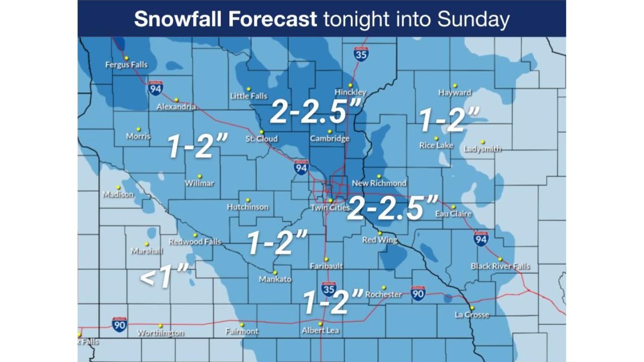
According to the National Weather Service Twin Cities/Chanhassen office, several hours of light snowfall will impact the region, producing widespread accumulations of 1 to 2 inches, with localized areas seeing up to 2.5 inches.
Snowfall Amounts and Areas Most Affected
Forecast maps indicate the highest snowfall totals are most likely across:
- Central and eastern Minnesota
- The Twin Cities metro
- Western portions of Wisconsin, including areas east of the Mississippi River
Lighter totals, generally under 1 inch, are expected farther southwest, while a broader zone of 1–2 inches stretches across much of the region.
While these totals are modest, forecasters emphasize that wind-driven impacts will play a bigger role than snowfall depth alone.
Timing: Snow Develops Overnight, Lingers Into Sunday
Snow is expected to spread from west to east, beginning Saturday evening and continuing through the overnight hours into Sunday morning. The most consistent snowfall is expected late tonight through early Sunday, with lingering snow showers possible into the afternoon.
Although snowfall rates will remain light, travel conditions may deteriorate quickly during periods of stronger wind.
Gusty Winds Increase Blowing Snow Risk
Breezy southerly winds will shift overnight, with gusts reaching 25 to 30 mph at times. These winds may:
- Blow loose snow across roadways
- Reduce visibility, especially in open farmland and exposed highways
- Create brief near-whiteout conditions in isolated areas
Even light snow can significantly impact travel when combined with strong winds, particularly outside of urban centers.
Visibility and Travel Concerns
The National Weather Service warns that blowing snow may reduce visibility, especially in:
- Open country
- Rural highways
- Areas with minimal tree or terrain shielding
Drivers may encounter rapid changes in visibility, making travel more hazardous overnight and early Sunday.
Wind Chill Adds to the Discomfort
In addition to snow and wind, cold air remains firmly in place, with wind chills dropping into the single digits and teens overnight. While not extreme, the combination of cold temperatures and wind will make outdoor conditions uncomfortable for extended periods.
What Drivers Should Know
Residents planning overnight or early Sunday travel should:
- Slow down and allow extra stopping distance
- Be prepared for sudden drops in visibility
- Use headlights and avoid abrupt maneuvers
- Keep winter emergency supplies in vehicles
Officials stress that conditions may look manageable at first but worsen quickly, particularly in open areas.
Bottom Line
A light but widespread snowfall, combined with gusty winds, will create reduced visibility and potentially hazardous travel conditions across Minnesota and Wisconsin overnight into Sunday. While snowfall amounts are not extreme, blowing snow will be the primary concern, especially for overnight and early morning travel.
Are you seeing blowing snow or slick roads where you live? Share your local conditions and stay with WaldronNews for continued winter weather updates across the Upper Midwest.