
Michigan, Ohio and Indiana Brace for Potentially Historic Instability Tuesday as All Severe Weather Hazards Remain on the Table From Detroit and Cleveland Through Toronto and Buffalo
DETROIT, Michigan — Forecasters are keeping a close and serious eye on Tuesday, April 14, as one of the most atmospherically loaded severe weather setups of the entire year takes shape across the Great Lakes region — with models showing some of the highest instability values seen in 2026 combining with favorable wind shear to put all severe weather hazards on the table for communities across Michigan, Ohio, Indiana, and the broader Detroit, Cleveland, Toledo, and Buffalo corridor during the evening hours of Tuesday.
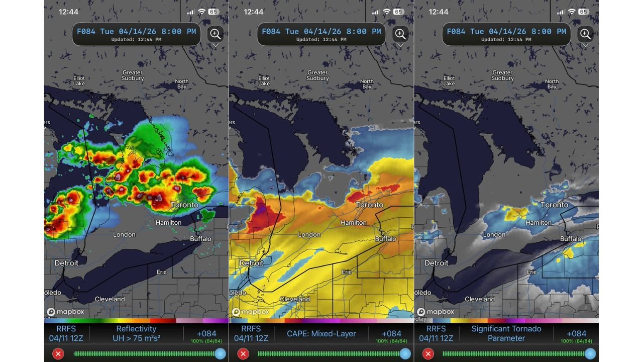
The RRFS model valid at 8:00 PM Tuesday, April 14 — run initialized from the April 11 12Z cycle — is painting a striking picture of an atmosphere primed for explosive thunderstorm development, with intense radar reflectivity, deep atmospheric energy, and elevated tornado parameters all converging over the same geographic area at the same time.
Cities and States in the Tuesday Severe Weather Corridor
- Michigan: Detroit and the surrounding southeast Michigan metro sit directly inside the zone where the highest storm rotation values and instability are focused Tuesday evening
- Ohio: Toledo, Cleveland, and Erie are within the severe weather corridor — Cleveland sits at the eastern edge of the highest threat zone
- Indiana: The broader Indiana corridor west of Detroit falls within the storm development area
- Ontario, Canada: London, Hamilton, and Toronto are directly in the path of Tuesday evening’s storm system — the RRFS model shows intense storm cells tracking directly through the Toronto metro by 8 PM Tuesday
- New York: Buffalo sits on the eastern edge of the threat corridor as storms push east through the Great Lakes
What the Models Are Showing
Three separate atmospheric datasets from the RRFS model are all telling the same dangerous story for Tuesday evening:
Storm Rotation (Updraft Helicity): The radar reflectivity map with Updraft Helicity greater than 75 m²/s² overlaid shows intense, concentrated storm cells with significant rotation signatures tracking directly through the Detroit, London, Hamilton, and Toronto corridor by 8 PM Tuesday. Multiple discrete storm cells with deep red and purple cores indicate organized, long-lived thunderstorms — the kind that produce large hail, damaging winds, and tornadoes.
Atmospheric Instability (Mixed-Layer CAPE): The Mixed-Layer CAPE map shows a broad plume of deep yellow and orange instability values streaming across the Detroit, Toledo, Cleveland, Buffalo, and Toronto region Tuesday evening. This represents some of the highest atmospheric energy available for thunderstorm development seen so far in 2026 — exactly what forecasters flagged when warning that Tuesday’s instability values could be record-setting for the year.
Significant Tornado Parameter (STP): The Significant Tornado Parameter map shows elevated values near Hamilton, Toronto, and Buffalo — with yellow and blue shading indicating a non-trivial tornado threat in those specific areas Tuesday evening. STP values above zero in a region with this level of instability and storm rotation deserve serious attention from residents.
The Two Limiting Factors Forecasters Are Watching
Despite the alarming model data, forecasters have identified two critical limiting factors that could reduce Tuesday’s overall severe weather impact — and both need to be understood by residents in the threat zone:
Zonal Flow — The upper-level wind pattern on Tuesday is running primarily west-to-east rather than the more favorable southwest-to-northeast orientation that typically supports the most organized, discrete supercell storms. Zonal flow tends to push storm systems through quickly and can limit the amount of time any individual storm has to organize and strengthen into a truly dangerous supercell.
Messy Storm Mode — Rather than producing clean, discrete supercells, Tuesday’s setup may generate a more chaotic cluster of storms — a squall line or messy convective complex. While this still brings damaging wind and hail threats, it reduces the probability of long-track tornadoes compared to a classic discrete supercell setup. However, embedded rotation within messy storm modes can still produce brief, difficult-to-warn-for tornadoes.
These limiting factors do not eliminate the threat — they shape it. All hazards remain on the table, and the instability values alone are enough to produce significant severe weather regardless of storm mode.
Why Detroit, Cleveland, and Toronto Cannot Ignore Tuesday
The combination of record-level instability for 2026 with favorable shear and elevated tornado parameters near Hamilton, Toronto, and Buffalo creates a scenario where even a partially favorable storm mode produces widespread severe weather impacts. Cities like Detroit and Toledo sit in the zone where the highest updraft helicity values are modeled — meaning rotating storms are not just possible but specifically forecast to track through these communities Tuesday evening.
For Toronto, Hamilton, and Buffalo, the Significant Tornado Parameter signal on the RRFS is a specific flag that cannot be dismissed. Even with limiting factors in play, when STP values are elevated and instability is at yearly highs, the atmosphere has the raw ingredients needed to produce tornadoes — and messy storm modes have historically caught communities off guard precisely because the threat feels less defined than a classic tornado outbreak.
Multi-Day Perspective
Tuesday arrives as the fourth consecutive day of elevated severe weather risk across different parts of the United States and Great Lakes region. Saturday brought the Nebraska-Kansas tornado outbreak. Sunday brought the Texas-Oklahoma conditional severe setup. Monday targets Minnesota, Wisconsin, and the Southern Plains. And now Tuesday closes out the week with what could be the most energetically loaded atmosphere of the entire sequence focused directly on Michigan, Ohio, and the Great Lakes.
This has been an extraordinary stretch of severe weather potential across the central and eastern United States, and Tuesday represents the final and potentially most powerful chapter of this multi-day outbreak.
What to Watch Tuesday
- Monitor SPC Day 2 and Day 1 outlooks as Tuesday approaches — the current forecast may be upgraded as model confidence in storm initiation and mode increases
- Residents across Detroit, Toledo, Cleveland, and the southeast Michigan corridor should have weather alerts active before Tuesday afternoon
- Toronto, Hamilton, London, and Buffalo residents should note the elevated Significant Tornado Parameter signal and treat Tuesday evening as a serious weather night despite being outside the typical U.S. severe weather zone
- The 8 PM CDT window is when the RRFS shows the most intense storm activity — evening plans across the entire Great Lakes corridor should account for potentially dangerous weather
- If storm mode trends toward discrete supercells rather than a messy line, the tornado threat increases dramatically — watch for forecaster updates on this key variable Monday and Tuesday morning
- Have multiple ways to receive warnings active Tuesday — the speed of this system means warning lead times could be shorter than typical
Tuesday is not a day to take lightly across Michigan, Ohio, Indiana, and the Great Lakes. The atmosphere is loaded with some of the highest energy values of the year, models are showing organized rotating storm signatures directly over Detroit, Cleveland, and Toronto, and all severe weather hazards remain firmly on the table.
WaldronNews.com will continue tracking Tuesday’s severe weather potential across Michigan, Ohio, Indiana, and the Great Lakes region and will provide updates as forecast confidence increases heading into the event.