
Mid-January Warm Spell Brings Above-Normal Temperatures to Illinois, Indiana, Ohio, Michigan, Pennsylvania, Kentucky, Tennessee, and New York
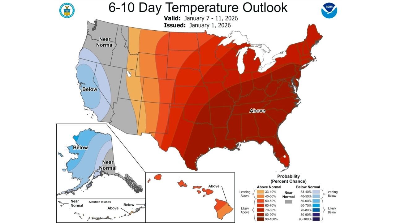
UNITED STATES — A notable shift in the winter weather pattern is setting up across a large portion of the eastern and central United States, with above-normal temperatures expected to dominate much of the Midwest, Ohio Valley, and Northeast during mid-January. Forecast guidance and national outlook data indicate a broad warm spell developing that will temporarily push winter cold out of several key states, including Illinois, Indiana, Ohio, Michigan, Pennsylvania, Kentucky, Tennessee, and New York.
This warm-up is expected to unfold during the January 7–11 timeframe, marking a clear departure from the colder conditions that have defined early winter for many communities across the region.
Widespread Temperature Anomalies Signal a Pattern Change
Forecast temperature outlooks show a strong signal for above-average temperatures covering a large swath of the eastern half of the country. The warmest anomalies are projected from the Midwest through the Ohio Valley and into the Northeast, where daytime highs are expected to rise well above seasonal norms.
In states such as Illinois, Indiana, and Ohio, temperatures are likely to climb into the 40s and 50s, a significant change for mid-January. Farther east, Pennsylvania and New York can also expect milder conditions, especially during daytime hours, reducing the frequency of hard freezes in many areas.
Michigan, Kentucky, and Tennessee See a Winter Pause
The warming trend will also be felt across Michigan, where colder air often lingers longer in January. While northern sections may remain cooler, much of the Lower Peninsula is expected to experience temperatures above normal for several consecutive days.
Farther south, Kentucky and Tennessee are forecast to remain firmly within the warm sector of this pattern. These states could see spring-like afternoons, with temperatures running well above average and minimal risk of winter precipitation during the warmest stretch.
What’s Driving the Mid-January Warm Spell
Meteorologists point to a large-scale atmospheric pattern shift that is allowing warmer air to surge northward across the central and eastern United States. The absence of strong Arctic intrusions during this period means no major cold fronts are expected to disrupt the warm pattern, allowing mild air to persist for several days.
This setup does not signal the end of winter but rather a temporary breakdown of the colder pattern, something that can occur periodically during January.
Impacts: Snowmelt, Rain Chances, and Travel
With temperatures rising above freezing across much of the region, snowmelt is likely, particularly in areas that recently received snowfall. While widespread flooding is not currently indicated, localized ponding and higher runoff are possible where snowpack melts quickly.
The warmer air may also bring increased chances for rain, especially in the Ohio Valley and portions of the Northeast. For travelers, the milder weather should improve road conditions compared to recent winter storms, though wet roads could still impact travel at times.
Cold Weather Still Expected to Return
Despite the warm spell, forecasters stress that winter is far from over. Seasonal temperatures are expected to return later in January, and additional cold snaps remain possible as the broader winter pattern continues to evolve.
Residents across the affected states are encouraged to take advantage of the brief break from winter, while staying prepared for colder weather to make a return later in the month.
As always, continue monitoring local forecasts for updated temperature trends and any changes to precipitation timing or intensity.
Stay with Waldron News for the latest weather updates, regional outlooks, and detailed breakdowns of what’s coming next.