
Mild Weekend Start in Wyoming Ends Quickly as Snow Returns to the West and Strong Winds Develop From Muddy Gap to Casper
WYOMING — A quiet and relatively mild start to the weekend is underway across much of the state, but that calm will not last long. New forecast data shows an approaching weather system will bring snow back to western Wyoming tonight, while strong, gusty winds develop across central Wyoming, particularly from Muddy Gap through Casper, creating changing travel and weather conditions through the next couple of days.
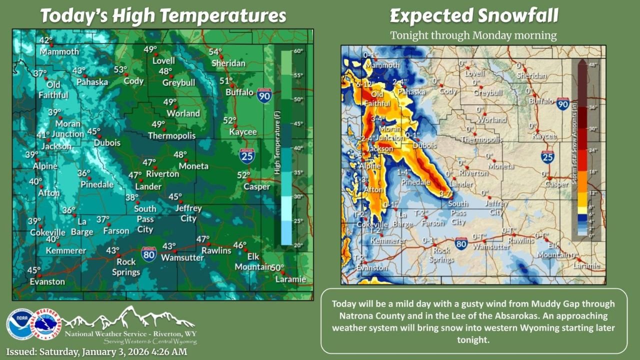
Mild and Dry Conditions to Start the Weekend
Most communities across Wyoming will experience a dry and seasonably mild day, with high temperatures reaching the upper 40s to low 50s in several lower-elevation areas. Cities such as Casper, Riverton, Rawlins, Buffalo, and Sheridan are expected to see some of the warmest readings, while higher elevations in western Wyoming remain cooler.
This brief break in winter weather may give the impression that conditions are stabilizing, but meteorologists emphasize that this is only a temporary pause before more active weather returns.
Snow Returns to Western Wyoming Tonight
By tonight, snow will redevelop across western Wyoming, especially along and west of the Absaroka Range, Teton Range, and western mountain corridors. Forecast snowfall maps show moderate to locally heavy snow bands forming from areas near Jackson, Moran, Old Faithful, Pinedale, and Alpine, with snow extending southward toward Afton and Star Valley.
The heaviest snowfall is expected in mountainous terrain, where accumulating snow could impact mountain passes, including travel routes near Togwotee Pass and Teton Pass. Snow is expected to continue overnight and into early Monday, with lighter accumulations possible in adjacent valleys.
Strong Winds Develop Across Central Wyoming
At the same time, strong and gusty winds will intensify across central Wyoming, particularly from Muddy Gap through Natrona County and the Casper area. Wind-prone locations along Interstate 25 and Interstate 80 corridors could experience hazardous crosswinds, especially for high-profile vehicles.
These winds may also contribute to blowing snow in areas where snowfall overlaps, further reducing visibility in open and exposed locations.
Travel Impacts Likely
The combination of mountain snow and strong winds raises concerns for difficult travel conditions, particularly:
- Western mountain passes overnight into Monday
- Wind-prone stretches of I-25 and I-80
- Areas near foothills and open basins where blowing snow may develop
Drivers are urged to monitor road conditions closely, allow extra travel time, and be prepared for rapidly changing weather, especially after sunset.
What to Expect Next
Forecast trends suggest that winter weather will remain active in western Wyoming, while central and eastern areas deal more with wind impacts rather than heavy snow. Temperatures will remain near to slightly above seasonal averages initially, but colder air could follow behind this system early next week.
Stay Prepared
Residents and travelers should:
- Secure loose outdoor items ahead of strong winds
- Check road and pass conditions before traveling
- Be prepared for winter driving conditions in western Wyoming
For continued updates on changing weather conditions, snowfall totals, and travel impacts across Wyoming, stay connected with Waldron News and check back frequently as this system moves through the region.