
Mississippi, Arkansas, Tennessee, and Northern Louisiana Face Severe Storm and Flash Flood Threat as Cold Front Moves In Friday
LOUISIANA — A strengthening cold front is expected to move into the lower Mississippi Valley on Friday, setting the stage for severe thunderstorms and flash flooding across Mississippi, Arkansas, Tennessee, and northern Louisiana, according to the latest forecast signals and storm outlooks.
Forecast data shows a growing overlap of deep moisture, strong wind energy, and upper-level support, creating conditions that could allow storms to intensify quickly as they track northeast through the region. While uncertainty remains on exact storm placement, confidence is increasing that parts of the Mid-South will see impactful weather before the front clears the area.
Why Friday’s Setup Is Raising Red Flags
Multiple weather ingredients are coming together ahead of Friday’s cold front. A positively tilted upper-level trough is helping funnel Gulf moisture northward, while strong winds aloft increase the risk for organized storms.
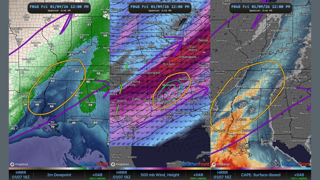
Surface dew points are expected to climb into the lower to mid-60s, unusually high for January, providing enough instability for storms to strengthen. Forecast guidance shows spin and wind energy overlapping with rich moisture, a combination that supports damaging winds and heavy rainfall.
Temperatures could briefly rebound into the upper 60s to near 70 degrees in parts of Mississippi and Tennessee if cloud breaks develop, further enhancing storm fuel before the front arrives.
Areas Most at Risk
Based on current guidance, the highest concern zone stretches from northern Louisiana through central and eastern Mississippi, into western and middle Tennessee, and parts of eastern Arkansas.
- Mississippi: Strong storms and heavy rainfall appear most likely, especially from central into northern sections of the state.
- Arkansas: Western and eastern Arkansas could see storms develop along and ahead of the front, with localized flooding concerns.
- Tennessee: Western and middle Tennessee, including the Memphis and Nashville corridors, may experience strong storms as the system advances northeast.
- Northern Louisiana: Early-day storms could produce heavy rain before activity shifts east.
While widespread tornado activity is not guaranteed, isolated spin-ups cannot be ruled out, particularly if storms become more discrete later in the day.
Flash Flooding a Growing Concern
In addition to severe weather, flash flooding is a notable risk, especially in areas that experience repeated rounds of rain. Forecast maps highlight a corridor where excessive rainfall potential overlaps with storm development, increasing the chance for rapid runoff.
Urban areas, low-lying locations, and places with saturated soils may be especially vulnerable if storms slow or train over the same regions.
Timing and What to Expect Next
Storms could begin developing early Friday, with the strongest activity expected from late morning through the afternoon and early evening as the cold front pushes east.
Meteorologists caution that details will continue to evolve, particularly regarding storm intensity and exact placement. Confidence is expected to improve with newer model runs and updated outlooks on Thursday.
What Residents Should Do Now
Residents across the lower Mississippi Valley and Mid-South should remain weather-aware heading into Friday. Make sure weather alerts are enabled, review safe shelter options, and avoid travel during heavy rain if flash flooding develops.
Stay with Waldronnews.com for continued weather updates, forecast breakdowns, and developing storm coverage as Friday’s system comes into sharper focus. If severe weather impacts your area, share what you’re seeing and join the conversation with our readers as conditions unfold.