
Missouri and Illinois See Sharp January Warm-Up as Temperatures Surge Well Above Normal Early Next Week After Cold Sunday
MISSOURI — After a seasonably cold January Sunday across the Mid-Mississippi Valley, temperatures are forecast to climb rapidly early next week, pushing well above normal across Missouri and Illinois, according to data from the National Weather Service in St. Louis. The warming trend will unfold quickly from Sunday through Tuesday, marking a notable shift in the region’s winter pattern.
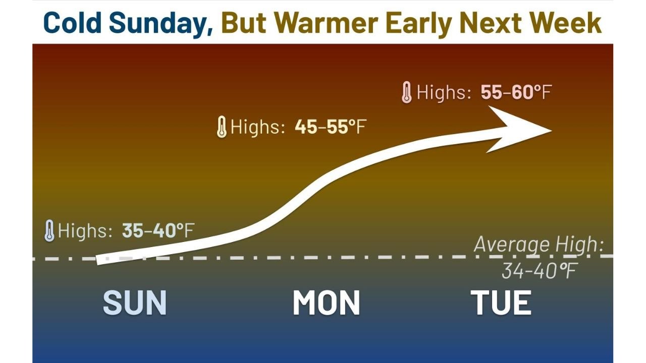
Forecast graphics show Sunday highs holding in the mid-30s to near 40 degrees, followed by a steady rise into the mid-40s and 50s on Monday, and then mid-50s to near 60 degrees by Tuesday, levels that exceed typical mid-January averages.
Cold Sunday Sets the Stage for a Rapid Change
Sunday will feel like a typical January day, with afternoon highs generally ranging from 35 to 40 degrees across eastern Missouri, western Illinois, and the St. Louis metro area. These readings align closely with normal January highs, which average between 34 and 40 degrees for this part of the Midwest.
By late Sunday night, however, the colder air mass begins to retreat as southerly flow strengthens, opening the door for a much milder pattern.
Monday Brings Noticeable Warming Across the Region
Temperatures will rebound quickly on Monday, with highs expected to reach 45 to 55 degrees across much of Missouri and Illinois. This represents a 10 to 15 degree jump in just 24 hours, signaling the start of a broader warm-up across the central U.S.
Residents will notice:
- Less biting cold during the morning hours
- Milder afternoons suitable for outdoor activities
- Reduced need for heavy winter layers
Tuesday Peaks With Well-Above-Normal Highs
By Tuesday, the warm-up reaches its peak, with forecast highs climbing into the 55 to 60 degree range. These values run well above mid-January norms, making Tuesday feel more like early spring than the heart of winter.
Forecasters note that while this warmth is welcome, it does not signal an end to winter, as temperature swings are common during January across the Midwest.
What This Means for Daily Life
The warming trend could have several short-term impacts:
- Improved travel conditions, with no cold-related icing concerns
- Snowpack melting, where any remains from previous systems
- Higher energy efficiency, as heating demand briefly drops
No significant precipitation or hazardous weather is currently tied to this warm-up, making it a relatively quiet stretch after recent active patterns.
A Temporary Break in a Typical January Pattern
Meteorologists stress that January warm spells are often short-lived, and colder air may return later in the month. Still, this early-week surge stands out as one of the warmer stretches so far this winter for Missouri and Illinois.
Enjoy the brief taste of milder weather, but keep winter gear handy. Stay with Waldron News for continued updates on Midwest temperature trends and any changes ahead as the pattern evolves.