
Monster Nor’easter Poised to Bury New Jersey Through New England With Over a Foot of Snow and Blizzard Conditions Sunday Into Monday
NORTHEAST UNITED STATES — A powerful nor’easter is on track to deliver a high-impact winter storm from New Jersey through New England Sunday into Monday, with forecasters warning of heavy snowfall totals exceeding one foot and blizzard conditions along the coast.
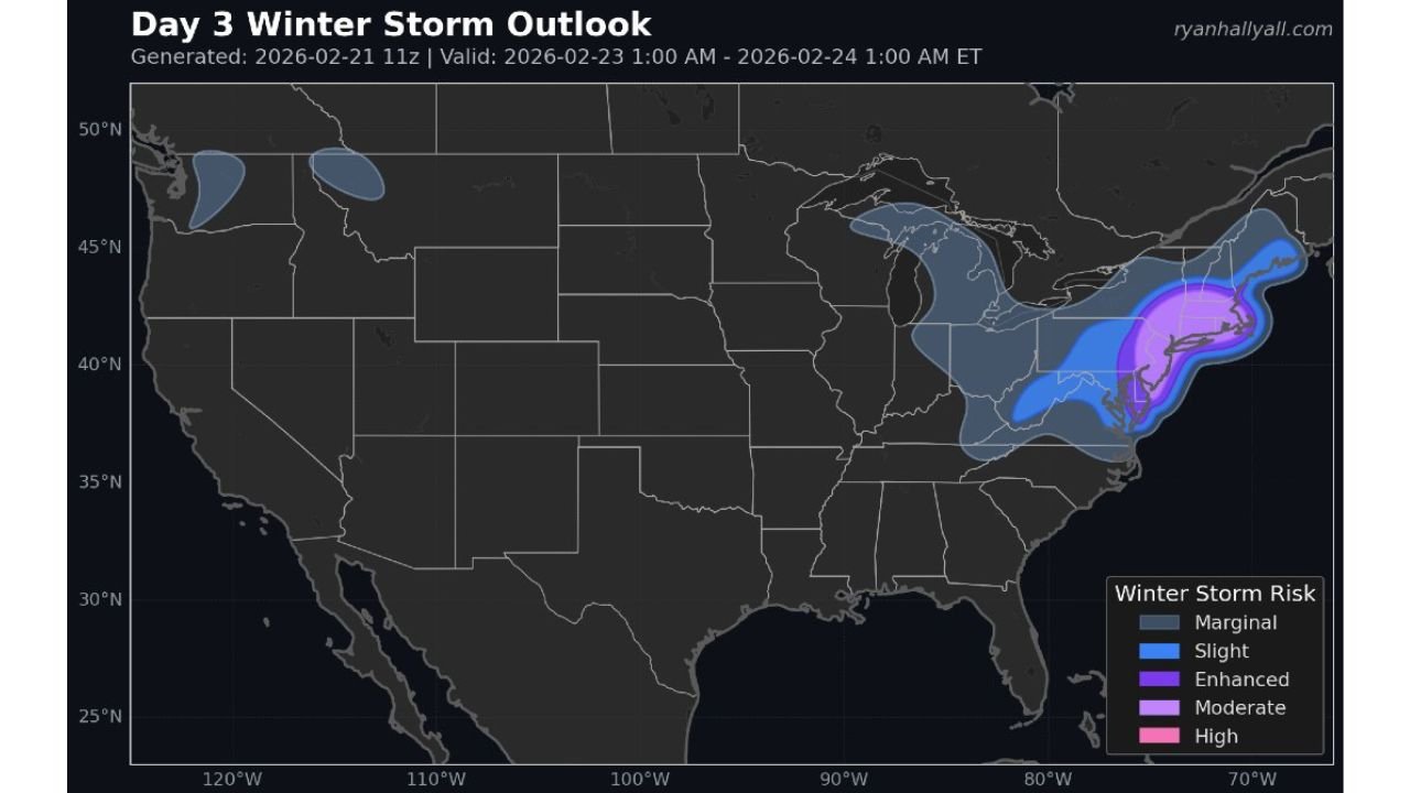
The latest Day 3 Winter Storm Outlook highlights a corridor of enhanced to moderate winter storm risk stretching from eastern Pennsylvania and New Jersey through New York City, Long Island, Connecticut, Rhode Island, and into eastern Massachusetts.
Highest Risk From Jersey Shore to Boston
The outlook map shows:
- Enhanced to Moderate risk centered on coastal New Jersey, New York City, Long Island, southern Connecticut, Rhode Island, and eastern Massachusetts.
- A broader Slight risk zone extending inland through eastern Pennsylvania, upstate New York, and interior New England.
This setup places major population centers directly in the storm’s core impact zone.
Over a Foot of Snow Likely in Coastal Areas
Current projections indicate many communities from:
- New Jersey
- New York City
- Long Island
- Southern Connecticut
- Rhode Island
- Boston and eastern Massachusetts
could receive more than 12 inches of snow, with locally higher totals possible where heavy snow bands persist.
The heaviest snow is expected near the coast, where strong Atlantic moisture will feed into the storm as it intensifies offshore.
Blizzard Conditions Along the Coast
Strong winds developing as the low pressure system deepens offshore may lead to:
- Near-zero visibility
- Blowing and drifting snow
- Dangerous travel conditions
- Potential scattered power outages
Coastal sections from the Jersey Shore through Long Island and into coastal New England are most at risk for blizzard-like conditions.
Inland Impacts Still Significant
Even outside the highest-risk coastal zone, snowfall will extend inland across:
- Eastern Pennsylvania
- Interior New York
- Portions of the Mid-Atlantic
- Interior southern New England
While totals may be somewhat lower than the immediate coast, significant accumulations are still expected.
Timing
Snow is expected to overspread the region Sunday, intensify overnight, and continue through Monday before gradually tapering from southwest to northeast.
Peak impacts will likely occur late Sunday into early Monday when snowfall rates are heaviest and winds strongest.
Bottom Line
A high-impact nor’easter is expected to bury parts of the Northeast with over a foot of snow, blizzard conditions along the coast, and significant travel disruptions from New Jersey to New England.
Residents in New York City, Long Island, coastal New Jersey, Connecticut, Rhode Island, and Boston should finalize preparations now and avoid unnecessary travel during peak storm hours.
Stay with Waldronnews.com for continuous updates as this major winter storm unfolds.