
New Mexico, Texas and Oklahoma Panhandles and Southwest Kansas Face Extreme Fire Weather Risk Sunday May 17 With Single Digit Humidity and Rapid Wildfire Spread Possible Including Amarillo, Liberal, Clovis, Plainview and Lubbock
AMARILLO, Texas – Dangerous and extremely critical fire weather conditions are in place across the southern High Plains today, Sunday, May 17, with an Extreme Fire Weather Risk zone covering eastern New Mexico into the Texas and Oklahoma Panhandles and southwest Kansas. Single-digit humidity, strong winds and critically dry fuels are combining to support rapid wildfire spread across a wide corridor including Amarillo, Liberal, Clovis, Plainview and Lubbock today.
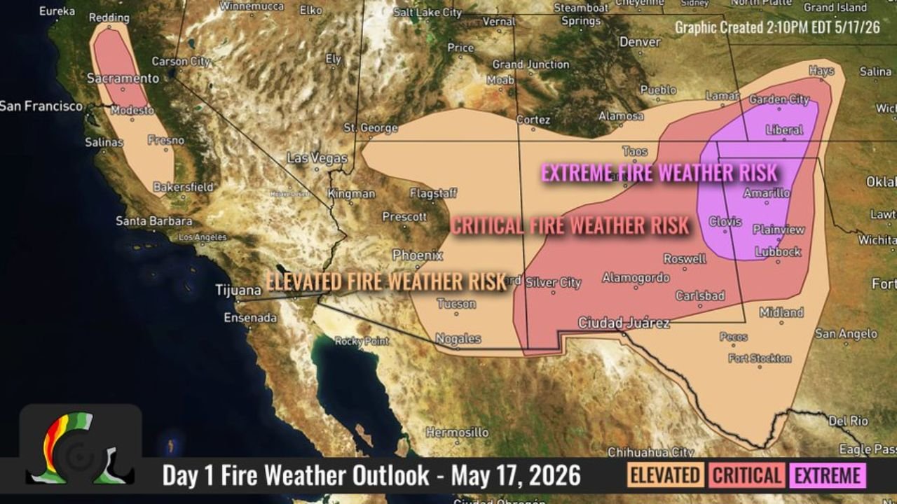
Three Fire Weather Risk Zones Sunday May 17
The Day 1 Fire Weather Outlook issued at 2:10 PM EDT Sunday, May 17, 2026 shows three escalating danger zones across the West and southern High Plains:
- The Extreme Fire Weather Risk zone shown in purple covers the most dangerous corridor, centered on eastern New Mexico, the Texas and Oklahoma Panhandles and southwest Kansas, including Amarillo, Liberal, Clovis, Taos and Garden City. This is where single-digit humidity, strong winds and critically dry fuels create conditions for explosive, rapidly spreading wildfires today.
- The Critical Fire Weather Risk zone shown in pink surrounds the extreme zone and covers a broader area including Roswell, Alamogordo, Cartsbad, Plainview, Lubbock and Midland, Texas, where dangerous fire weather conditions are in place but slightly less extreme than the purple zone.
- The Elevated Fire Weather Risk zone shown in light pink extends the threat into Arizona, Nevada and portions of California and New Mexico, where above-normal fire weather conditions exist but do not yet reach the critical or extreme threshold.
What Extreme Fire Weather Conditions Mean on the Ground
The combination of factors in place today across the Texas and Oklahoma Panhandles and eastern New Mexico creates some of the most dangerous wildfire conditions possible:
- Single-digit humidity means the air is nearly completely dry, stripping moisture from grass, brush and trees and turning them into ready fuel for any ignition source.
- Strong winds allow any fire that starts to spread with extreme speed across the landscape, potentially outrunning evacuation efforts and consuming large areas within minutes.
- Critically dry fuels built up over dry weeks mean even a small spark from a vehicle, power line or debris burn can ignite a fast-moving wildfire that is extremely difficult to contain under these wind conditions.
Cities Inside the Extreme and Critical Zones Today
- Amarillo and Lubbock, Texas are within or near the Extreme Fire Weather Risk zone and face the threat of rapidly spreading wildfires today, Sunday, May 17.
- Liberal and Garden City, Kansas sit inside the Extreme zone in southwest Kansas and face dangerous fire weather conditions through today.
- Clovis, Taos, Roswell, Alamogordo and Cartsbad, New Mexico are within the Extreme and Critical fire weather zones today.
- Plainview, Midland and San Angelo, Texas fall within the Critical Fire Weather Risk zone for Sunday, May 17.
- Lamar and Pueblo, Colorado sit on the northern edge of the fire weather threat area today.
What You Must Not Do Today in the Extreme Zone
Anyone across Amarillo, Liberal, Clovis, Garden City, Plainview and Lubbock must avoid all outdoor burning, debris burning and any activity that could produce a spark today. Do not drag chains or equipment along roadways. Do not park vehicles on dry grass. Under extreme fire weather conditions a single spark can ignite a wildfire that covers thousands of acres within hours. If you see smoke, call 911 immediately and do not attempt to fight the fire yourself.
WaldronNews.com will continue tracking this Extreme Fire Weather Risk across eastern New Mexico, the Texas and Oklahoma Panhandles and southwest Kansas and will provide updates as fire reports, wind speeds and humidity levels develop throughout Sunday, May 17.