
New York, Pennsylvania, New Jersey, Maryland, Virginia, and North Carolina Could See a More Active Winter Pattern After Mid-January as Jet Stream Signals Shift
UNITED STATES — After a prolonged stretch of warmer-than-normal January weather, new upper-atmospheric pattern data suggests parts of New York, Pennsylvania, New Jersey, Maryland, Virginia, and North Carolina could see a transition toward a more active winter setup after the middle of the month, though meteorologists emphasize that forecast confidence remains low at this range.
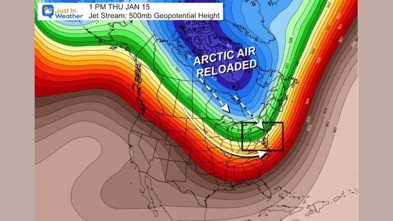
Jet stream analysis shows a temporary ridge developing first, followed by signs of a deeper trough forming across the Eastern United States — a configuration that can support renewed cold air intrusions and potential winter storm development later in January.
Short-Lived January Warmth Expected Before Pattern Changes
Forecast guidance indicates a bulging ridge in the jet stream later this week, allowing warmer air to surge northward across much of the East Coast. This setup could push temperatures well above seasonal averages, with some locations briefly reaching the 50s to near 60 degrees, an unusual but not unheard-of occurrence in January.
Meteorologists caution that this warmth is expected to be temporary, not a signal that winter is ending early.
Cold Front Likely to Reset Conditions to Seasonal Levels
Following the warm stretch, data shows a cold front pushing through next weekend, returning temperatures closer to normal January values across the Mid-Atlantic and Northeast. While this front alone is not expected to bring major winter weather, it may help establish a more favorable background pattern for later developments.
This transition period is important, as it precedes the timeframe now drawing increased attention from forecasters.
Mid-January Window Emerging as Key Focus
The period between January 15 and January 17 is increasingly being watched as a potential turning point. Upper-level pattern projections suggest a negative-tilt trough could develop across the Eastern U.S., a configuration often associated with stronger storm systems when cold air and moisture align properly.
At the jet stream level, current signals point to:
- Cold air reloading from the north
- Increased atmospheric energy over the East
- A pattern more supportive of winter storm development
However, forecasters stress that specific storm details cannot yet be determined.
Why Confidence Remains Limited Right Now
Despite encouraging signals aloft, model inconsistency remains high, with significant differences between individual forecast runs. Because of this, meteorologists are avoiding precise snowfall amounts, storm tracks, or timing until the pattern becomes clearer.
Accuracy at 10–11 days out is inherently low, and meaningful refinement is expected only as the window draws closer.
Climatology Still Favors Late-January Winter Weather
Historically, a large portion of snowfall across New York, Pennsylvania, New Jersey, Maryland, Virginia, and North Carolina occurs between mid-January and late February. This period represents the heart of winter climatologically, reinforcing that the season still has ample time to deliver impactful weather.
While no storm is guaranteed, the broader pattern suggests winter is not finished.
What Residents Should Watch Next
- Continued evolution of the jet stream pattern
- Signs of sustained cold air supply into the East
- Improved model agreement over the next week
Updates will become more meaningful as the mid-January window approaches.
What do you think — will winter finally make a comeback across the East, or will January stay quiet longer? Share your thoughts and follow continued coverage at WaldronNews.com.