
Northern Illinois and Southern Wisconsin Snow Threat: Chicago Area Faces Strong Chance of Several Inches Wednesday Night Into Thursday Morning
NORTHERN ILLINOIS — A new round of accumulating snow is increasingly likely across northern Illinois and southern Wisconsin Wednesday night into Thursday morning, with ensemble model guidance centering the heaviest swath directly over the Chicago metro area and surrounding counties.
Forecast data indicates that several inches of snow could fall if the current storm track holds, raising the potential for travel disruptions during the Thursday morning commute.
Snow Swath Focused Over Northern Illinois
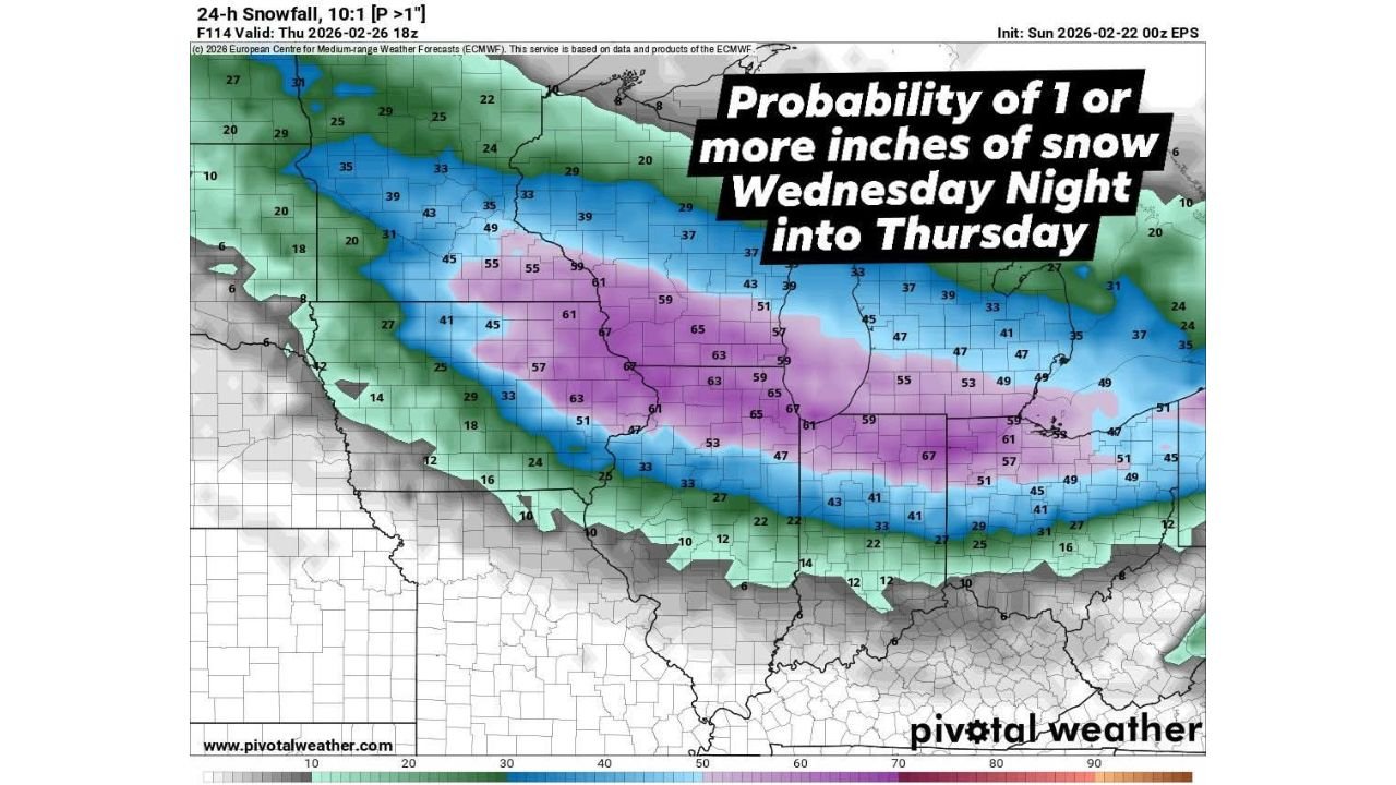
Latest probability guidance for at least 1 inch of snowfall in a 24-hour period shows the highest confidence corridor stretching from:
- North-central Iowa
- Across northern Illinois, including Chicago
- Into southern Wisconsin
- Extending into southern Michigan
Across northern Illinois — including the Rockford, DeKalb, and Chicago regions — probabilities for at least 1 inch of snow range between 55% and 67%, indicating a strong likelihood of measurable accumulation.
Southern Wisconsin communities near the Illinois border are also included in this higher-probability zone, suggesting the snow axis will not be confined to Illinois alone.
Chicago Metro In Prime Accumulation Zone
The Chicago metro area appears to sit near the center of the projected snowfall band.
Probability values around:
- 61% to 67% across much of northeastern Illinois
- Similar values extending eastward into northwest Indiana
- 59% to 65% across parts of southern Michigan
This suggests a broad and organized swath of snow rather than scattered, hit-or-miss activity.
If the system maintains its projected intensity, several inches of accumulation would be possible, particularly in areas north and west of downtown Chicago where snowfall rates could briefly intensify overnight.
Lower Probabilities South of I-80
Areas farther south — including central Illinois and portions of Indiana — show lower confidence, generally ranging between:
- 20% to 40% probabilities
This indicates a sharper southern cutoff to the snow shield. Communities south of I-80 may see lighter amounts or potentially miss out on more significant accumulation if the track shifts even slightly north.
The tight gradient underscores how sensitive totals will be to small changes in storm positioning.
Southern Wisconsin Also Impacted
Cities across southern Wisconsin, including Kenosha and Milwaukee’s southern suburbs, are positioned within the 40% to 55% probability range for at least 1 inch.
While not as high as northern Illinois, these values still support a meaningful chance for accumulating snowfall extending into Thursday.
Timing and Travel Concerns
The primary window for snowfall is expected:
- Late Wednesday evening
- Continuing overnight
- Tapering Thursday morning
This timing raises concern for slick roads during the early commute period across northern Illinois and southern Wisconsin.
If snowfall rates increase overnight, untreated roads and bridges could become hazardous before daybreak.
What Could Change?
While ensemble guidance shows a clear signal for accumulating snow, exact totals will depend on:
- The precise placement of the snow band
- Temperature profiles overnight
- Storm intensity as it crosses the region
A northward shift could bring heavier snow into Wisconsin while trimming totals south of Chicago. A slight southward shift would increase totals closer to central Illinois while reducing amounts near the Wisconsin border.
Bottom Line
Confidence is growing that northern Illinois — including Chicago — and southern Wisconsin will see accumulating snow Wednesday night into Thursday morning.
With probabilities exceeding 60% across much of the region for at least 1 inch — and the potential for several inches if current projections hold — residents should prepare for winter travel impacts.
WaldronNews.com will continue monitoring forecast updates as the midweek snow system approaches.