
Oklahoma, Texas, Arkansas, Missouri, and Mississippi Placed Under Marginal Severe Weather Risk as SPC Flags Day 3 Storm Threat Across Central U.S.
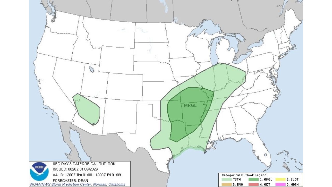
UNITED STATES — The Storm Prediction Center (SPC) has issued a Day 3 Marginal Risk for severe weather stretching from eastern Oklahoma and eastern Texas into Arkansas, Missouri, and parts of the lower to mid Mississippi Valley, signaling the potential for isolated strong storms as a developing system moves through the region later this week.
The outlook, released early Tuesday morning, highlights a broad swath of the central United States where atmospheric conditions may become just favorable enough to support a few severe thunderstorms, though widespread or significant severe weather is not expected at this time.
What a Marginal Risk Means
A Marginal Risk (Level 1 of 5) is the lowest category on the SPC severe weather scale, indicating that severe storms are possible but limited in coverage and intensity. In these setups, storms may briefly reach severe levels, producing hazards such as:
- Isolated damaging wind gusts
- Small hail
- A very low-end tornado threat, mainly where storms can briefly rotate
Forecasters stress that many areas within a Marginal Risk may see no severe weather at all, but a few localized storms could still cause impacts.
Areas Currently Included in the Risk Zone
Based on the latest SPC maps, the Marginal Risk extends across:
- Eastern Oklahoma
- Eastern and northeastern Texas
- Arkansas
- Southern and central Missouri
- Northern Mississippi and parts of the lower Mississippi Valley
The risk zone follows a corridor where Gulf moisture is expected to interact with a passing upper-level disturbance and a developing frontal boundary.
Why Confidence Remains Limited
At Day 3 range, forecast confidence is still moderate to low, with several key ingredients not yet firmly aligned. While wind shear may be sufficient to organize storms, instability appears marginal, especially if cloud cover or limited heating reduces storm intensity.
This type of setup often produces messy or scattered convection, rather than well-organized storm lines or supercells. Small changes in timing or moisture return could either slightly enhance or entirely suppress the severe threat.
What Could Change Before the Event
As the system draws closer, the SPC may:
- Adjust the Marginal Risk boundaries
- Introduce higher-resolution hazard probabilities
- Remove the risk altogether if conditions trend weaker
Conversely, if instability improves more than expected, localized upgrades could be considered in later outlooks.
What Residents Should Do Now
While this is not a high-impact severe weather setup, residents across the highlighted states should remain weather-aware later this week, especially during periods of thunderstorms. It’s recommended to:
- Monitor updated SPC outlooks and local forecasts
- Enable weather alerts on phones and devices
- Avoid relying on early, exaggerated social media forecasts
At this stage, the outlook is best described as low-end but worth watching, particularly for those in eastern Oklahoma, eastern Texas, and the Ozarks.
Looking Ahead
Meteorologists will continue refining the forecast as higher-resolution data becomes available. The next 24–48 hours will be critical in determining whether this system remains a minor winter-season storm threat or evolves into something more impactful.
For continued forecast updates, severe weather explanations, and regional impact tracking, stay connected with WaldronNews.com.