
Oregon Valley Fog Expands Across West Central Mountains and Malheur County as Morning Inversions Set In
OREGON — Valley fog is becoming increasingly widespread across Oregon’s West Central Mountains and Malheur County, with forecasters warning that morning fog coverage is expected to increase in the coming days as a persistent temperature inversion settles over the region. The fog is forming primarily in low-lying valleys during overnight and early morning hours, reducing visibility and creating hazardous travel conditions in some areas.
Where Fog Is Developing Right Now
Early observations show patchy to locally dense valley fog forming in sheltered valleys, especially in:
- The West Central Mountains of Oregon
- Malheur County, particularly low elevations and river valleys
As overnight cooling strengthens, these fog pockets are expected to expand and become more consistent each morning.
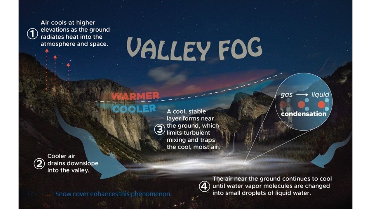
Why Valley Fog Is Increasing
The current pattern favors strong overnight cooling and calm winds, allowing cold air to pool in valleys. According to meteorologists, a temperature inversion is developing — a setup where cooler air becomes trapped near the ground while warmer air sits above it.
This process unfolds in several steps:
- After sunset, the ground rapidly loses heat, cooling the air near the surface
- Colder, denser air flows downslope and collects in valley bottoms
- A stable layer forms, limiting air mixing and trapping moisture
- As temperatures continue to drop, water vapor condenses into tiny droplets, forming fog
Snow cover in some higher terrain is enhancing this effect by accelerating surface cooling, making fog more likely and longer-lasting.
What an Inversion Means for Visibility
Once established, inversions can lock fog in place for hours, sometimes persisting well into late morning or early afternoon. In the densest fog zones, visibility can drop to less than a quarter mile, especially near rivers, creeks, and open lowlands.
Drivers may encounter:
- Sudden visibility drops when entering valleys
- Fog that appears thicker near dawn
- Slow clearing after sunrise if clouds or weak sunshine persist
How Long Will This Pattern Last?
Forecast guidance suggests valley fog will continue to increase in coverage each morning until a weather system arrives strong enough to disrupt the inversion. That would typically require:
- Stronger winds
- A passing storm system
- Or increased cloud cover overnight
Until then, the fog pattern is expected to repeat daily, particularly during the coldest morning hours.
Safety Impacts and Travel Concerns
Morning commuters, ranchers, and long-haul drivers in eastern and central Oregon should plan for reduced visibility and slick road surfaces, especially where fog combines with freezing temperatures.
Officials advise:
- Using low-beam headlights in fog
- Slowing down and increasing following distance
- Being cautious near bridges and shaded roadways
Bottom Line
Valley fog is becoming a regular early-morning feature across Oregon’s West Central Mountains and Malheur County, driven by strong overnight cooling and a developing inversion. Fog coverage is expected to increase in the mornings, with slow clearing likely on many days until the weather pattern changes.
Stay alert during early travel hours and continue checking updated local forecasts for changes in visibility and temperature trends.
For continued local weather updates and impact-focused forecasts, stay connected with Waldron News and share what conditions look like in your area this morning.