
Pennsylvania, New York and West Virginia to See 2–6 Inches as Fast-Moving Clipper Sweeps Through; Minor Accumulations Expected for New Jersey, Maryland and New England Wednesday Morning
PENNSYLVANIA — A quick-moving Alberta clipper system is set to race across the Northeast early Wednesday morning, bringing light snow and minor accumulations from West Virginia and western Pennsylvania through New York and into New England, with the greatest totals expected north of the Pennsylvania Turnpike and across higher elevations.
The system is not expected to be a major winter storm, but it could create slick spots and minor travel impacts during the Wednesday morning commute — especially in interior areas.
2–4 Inches Across Central and Northern Pennsylvania and Upstate New York
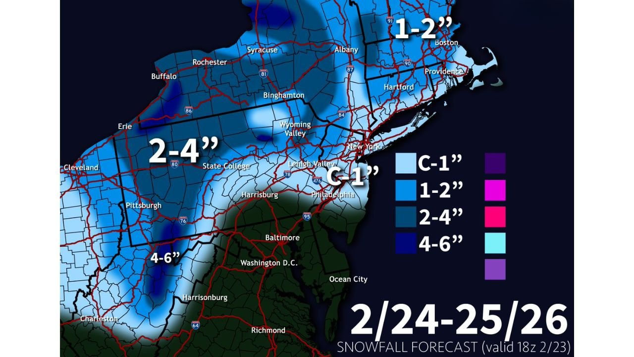
Forecast maps valid February 24–25, 2026 show a swath of 2–4 inches stretching across:
- Central Pennsylvania, including State College and areas north of Harrisburg
- Northern Pennsylvania toward Erie
- Upstate New York, including Binghamton, Syracuse, Rochester and Albany
This corridor represents the core of the clipper’s light but steady snowfall.
Communities along Interstate 80 in Pennsylvania and Interstate 81 in New York could see measurable snow during the pre-dawn to mid-morning hours.
4–6 Inches Possible in the Mountains of West Virginia and Southwest Pennsylvania
Localized higher totals of 4–6 inches are projected in elevated terrain across:
- Eastern and central West Virginia
- The higher elevations near Harrisonburg, West Virginia
- Parts of southwest Pennsylvania
These areas often benefit from upslope enhancement as northwest winds develop behind clipper systems.
Travel through mountain passes could become briefly snow-covered before conditions improve later Wednesday.
1–2 Inches for New England and Portions of New York
Farther east, lighter totals of 1–2 inches are expected across:
- Eastern New York
- Western and central Massachusetts
- Connecticut
- Rhode Island
- Much of interior New Hampshire and Vermont
Cities such as Albany, Hartford, Providence and Boston appear positioned for generally light snowfall accumulations.
This will likely be enough for a coating to a couple inches, but not a high-impact event.
Coating to 1 Inch Near Philadelphia, New York City and Southern New Jersey
Closer to the Interstate 95 corridor, snowfall amounts taper further.
Forecast projections show:
- C–1 inch (coating to 1”) near Philadelphia, Pennsylvania
- Minimal accumulation in New York City, New York
- Light coating potential in parts of northern New Jersey
- Limited accumulation across northern Maryland
Areas south of Baltimore and Washington, D.C. are expected to see little to no accumulation as the system moves through quickly and moisture remains limited.
Minor Morning Commute Impacts Likely North of the Pennsylvania Turnpike
While this is not a major storm, minor travel impacts are possible Wednesday morning, particularly:
- North of the Pennsylvania Turnpike
- Across interior New York State
- In mountainous portions of West Virginia and Pennsylvania
Clipper systems are known for quick bursts of light to moderate snow, which can briefly reduce visibility and create slick road conditions before tapering off.
Fast In, Fast Out System
This clipper will be a classic fast-mover:
- Snow developing late Tuesday night
- Passing through early Wednesday morning
- Ending by late morning or early afternoon
Because of its speed, widespread heavy accumulation is not expected.
However, untreated roads and secondary highways could become slick during peak travel hours.
WaldronNews.com will continue monitoring updates as this Wednesday morning clipper approaches Pennsylvania, New York, West Virginia, New Jersey, Maryland, and New England.