
Pennsylvania, New York, Massachusetts, Maryland, and New Jersey Could See Late-Week Nor’easter With Snow Axis Inland and Rain Changing to Snow Along the Coast
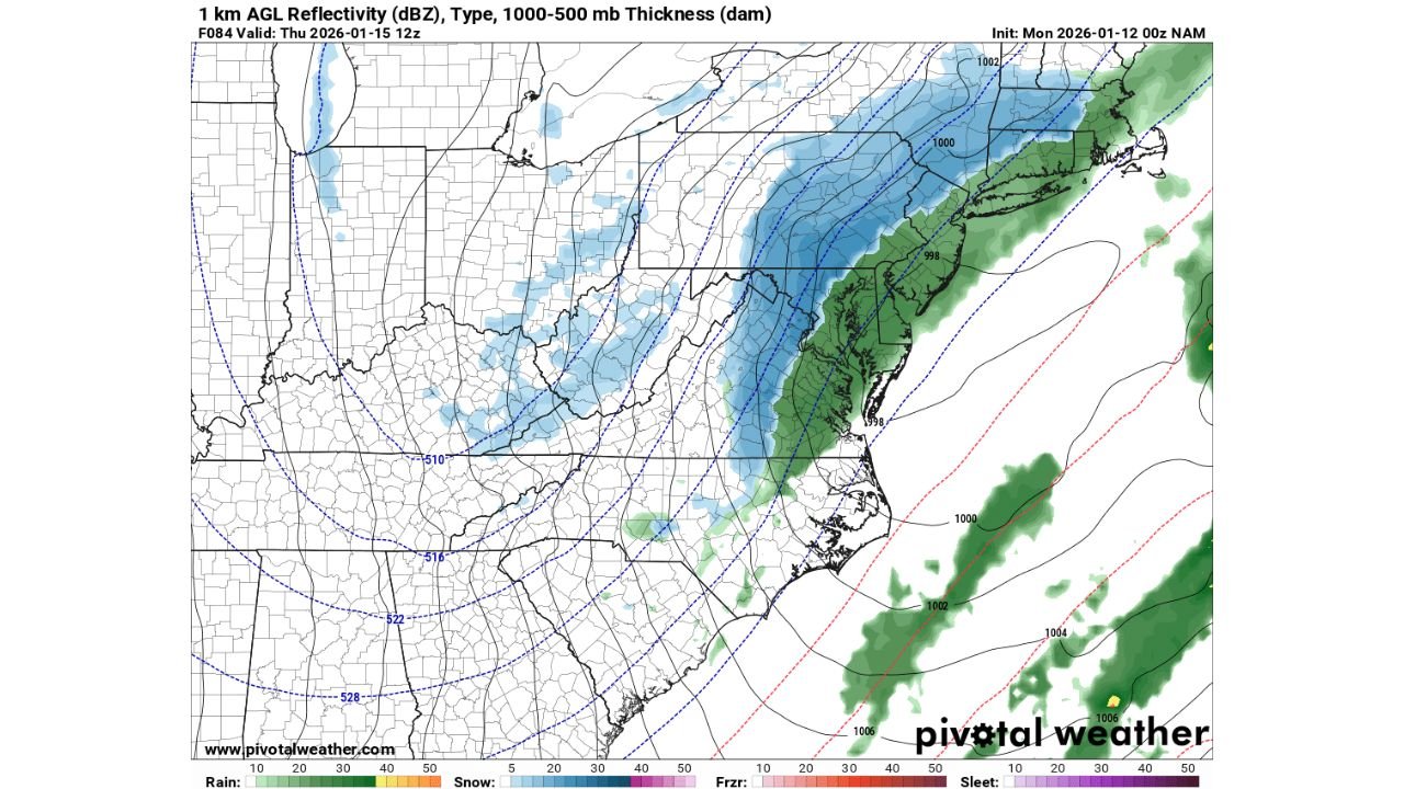
UNITED STATES — A new long-range run of the 0z NAM model is hinting at the development of a Nor’easter from Thursday into Friday, stretching from Washington, D.C. through Pennsylvania and New York and into Massachusetts. While the system is still at the far edge of model reliability, the latest guidance aligns with earlier signals pointing to a potential inland snow axis with rain-to-snow transitions closer to the coast.
What the NAM Model Is Suggesting
According to the latest guidance, the NAM depicts a developing coastal low tracking northeast, with the primary axis of snow setting up inland from:
- Washington, D.C.
- Harrisburg and Scranton, Pennsylvania
- Poughkeepsie, New York
- Worcester, Massachusetts
This corridor would place much of central and northeastern Pennsylvania, the Hudson Valley, and interior New England on the colder side of the storm if the scenario verifies.
Coastal Cities May Start as Rain
For coastal plain cities, including:
- Baltimore, Maryland
- Philadelphia, Pennsylvania
- New York City
- Boston, Massachusetts
the NAM indicates rain initially, followed by a changeover to snow on the backside of the storm as colder air wraps in late. Some snow may also reach as far inland as the Lehigh Valley, depending on how quickly temperatures fall.
This setup is typical of marginal coastal winter storms, where timing of cold air arrival becomes the deciding factor between impactful snow and mostly rain.
Why Confidence Is Still Limited
It’s important to stress that this model run is at maximum forecast range, meaning:
- Storm placement could shift significantly
- The rain–snow line could move east or west
- The storm could weaken or track farther offshore
At this stage, the NAM should be viewed as a first guess, not a final forecast. However, its agreement with earlier signals adds credibility to the idea that interior areas have a higher snow potential than the immediate coast.
What to Watch Over the Next Few Days
Key factors that will determine impacts include:
- How close the coastal low tracks to shore
- How quickly cold air drains southward behind the storm
- Whether precipitation rates are strong enough to cool surface temperatures
Even a small shift in storm track could dramatically change snowfall outcomes, especially near the I-95 corridor.
Potential Impacts if the Scenario Holds
If the current idea verifies:
- Interior Pennsylvania, New York, and Massachusetts could see accumulating snow
- Coastal cities may deal with rain changing to snow late, possibly affecting Friday morning travel
- The heaviest snow would likely fall north and west of major coastal metros
Bottom Line
There is early but notable model support for a late-week Nor’easter impacting parts of Pennsylvania, New York, Massachusetts, Maryland, and New Jersey, with the best snow chances inland and more mixed precipitation closer to the coast. Confidence remains low, but the setup is one worth watching closely.
Forecast clarity should improve significantly over the next 24 to 48 hours.
Stay tuned for updates and localized impact breakdowns, and follow ongoing coverage on Waldron News as this potential winter storm comes into better focus.