
Snow Chances Remain Limited Across Maryland, Virginia, and Pennsylvania as Warm Pattern Persists Into Late January
VIRGINIA — Many residents are asking the same question: when will it snow again? Based on the latest forecast data and long-range model guidance, the short answer is not anytime soon, as a milder weather pattern dominates through the weekend and into early next week, keeping meaningful snow chances largely off the table.
Temperatures are expected to climb into the 50s and even low 60s, well above seasonal averages, effectively ruling out snow in the near term.
Warm Weekend Pattern Shuts Down Immediate Snow Potential
Forecast guidance shows a strong warm-up through the weekend, with daytime highs pushing far above freezing across much of the Mid-Atlantic.
With temperatures this mild:
- Any precipitation would fall as rain
- Cold air needed for snow is absent
- Ground temperatures continue to warm, reducing accumulation potential even if colder air briefly returns
While somewhat cooler air may move in next week, it does not appear cold or organized enough to support a meaningful snow event.
Social Media Hype vs. Reality
There has been increasing chatter on social media suggesting snow chances could rise toward the end of next week, but forecasters caution that the overall weather pattern does not currently support that idea.
As winter weather experts note, everything would need to line up perfectly — storm track, cold air timing, and atmospheric support — and that alignment is not showing up consistently in guidance right now.
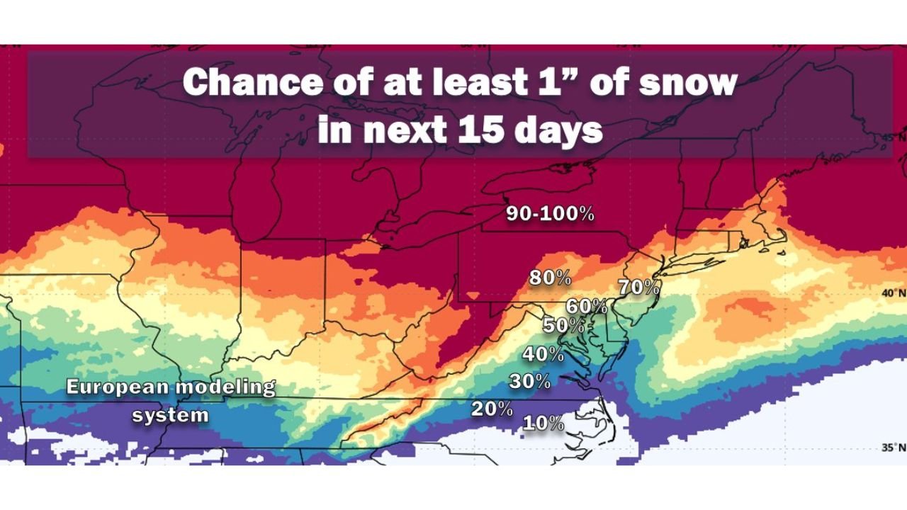
What the European Model Shows for the Next 15 Days
Looking farther ahead, European ensemble guidance paints a more realistic picture of snow potential:
- Roughly 50–50 odds of at least 1 inch of snow over the next 15 days
- These odds are near normal for mid-January
- Higher probabilities remain north and west of the Mid-Atlantic
- Lower probabilities closer to the coast and southward
This does not signal an imminent snowstorm, but it does show that snow is still climatologically possible as colder air slowly works back into the region.
Coldest Part of the Year Is Still Ahead
Mid to late January is typically the coldest stretch of the year, and with temperatures expected to trend lower over time, snow chances can emerge quickly if the pattern shifts.
However, at this time:
- No specific storm is locked in
- No clear snow signal is present
- Any snow chance would require rapid pattern changes
Bottom Line
Despite growing interest and speculation, no clear snow opportunity is on the horizon right now for the Mid-Atlantic. Warm temperatures through the weekend and only marginal cooling next week keep snow chances limited.
That said, this is the heart of winter, and patterns can change fast. WaldronNews.com will continue to monitor trends closely and provide updates if a legitimate snow threat begins to develop.