
Southern Ontario and Western New York Face Extreme Blizzard and Flash Freeze Threat as Backside of Storm Slams Region December 29–30
WESTERN NEW YORK — A dangerous backside winter storm is expected to impact areas east of Lake Huron and Lake Ontario from late Monday into early Tuesday, bringing blizzard conditions, violent wind gusts, flash freezing temperatures, and severe travel disruptions, according to the latest impact mapping.
Forecasters warn this system could become one of the most impactful winter events of the season for parts of southern Ontario and the Buffalo–Niagara region if current projections hold.
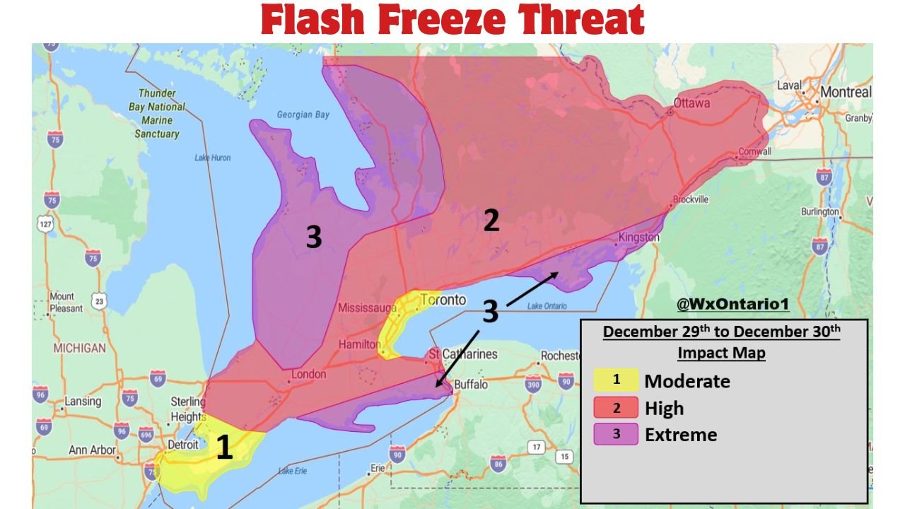
Extreme Impact Zone: Blizzard Conditions and Power Outage Risk
The highest-impact zone, labeled “Extreme”, includes portions of southern Ontario near Lake Huron and Lake Ontario, as well as areas near Buffalo and the Niagara Frontier.
In these locations, conditions may include:
- Blizzard conditions with winds gusting 70–100+ km/h
- Heavy lake-effect snow with blowing and drifting
- Near-zero visibility at times
- Extreme travel impacts, including potential road closures
- Power outages possible due to strong winds and heavy snow load
A rapid flash freeze is also expected as a sharp cold front moves through early Tuesday, turning wet roads into ice in a matter of minutes.
High Impact Areas: Severe Travel Conditions Likely
Surrounding regions marked under the “High” category are expected to experience:
- Significant blowing snow
- Wind gusts of 60–80+ km/h
- Wrap-around flurries or periods of light snow
- Flash freezing conditions as temperatures crash
Travel across these zones may become dangerous to nearly impossible, especially overnight into the Tuesday morning commute.
Moderate Impact Zone: Wind-Driven Snow and Slick Roads
Areas labeled “Moderate” are forecast to see:
- Bursts of flurries or snow squalls
- Wind gusts reaching 60–80 km/h
- Flash freeze potential behind the cold front
- Minor to locally significant travel impacts
Even in these lower-impact zones, rapidly changing road conditions could catch drivers off guard.
Timing: When Conditions Deteriorate
- Late Monday (Dec 29): Winds increase, snow bands develop
- Overnight into early Tuesday (Dec 30): Peak impacts with blizzard conditions and flash freeze
- Tuesday morning: Ongoing lake-effect snow and dangerous travel
Forecasters note that conditions may worsen quickly with little warning, especially once the cold front passes.
Officials Urge Caution Ahead of the Storm
Residents across southern Ontario and western New York are urged to:
- Avoid unnecessary travel during peak impact hours
- Prepare for possible power outages
- Monitor local alerts and road closures
- Use extreme caution if traveling overnight
A more detailed snow squall forecast is expected to be issued as the event draws closer.
What are conditions like where you are — strong winds, snow bands, or rapidly freezing roads? Share your local updates and stay connected with WaldronNews.com for continued winter storm coverage and regional impact alerts.