
Tennessee Valley Could See Late-January Snow as Winter Storm Signal Emerges Across Tennessee, Alabama, and Northern Mississippi
TENNESSEE — Snow is increasingly appearing on long-range forecast models for parts of the Tennessee Valley late this week, raising early attention across Tennessee, northern Alabama, and northern Mississippi as a potential winter weather setup begins to take shape. While confidence remains limited at this range, ensemble guidance shows a notable signal for measurable winter precipitation, including the possibility of accumulating snow.
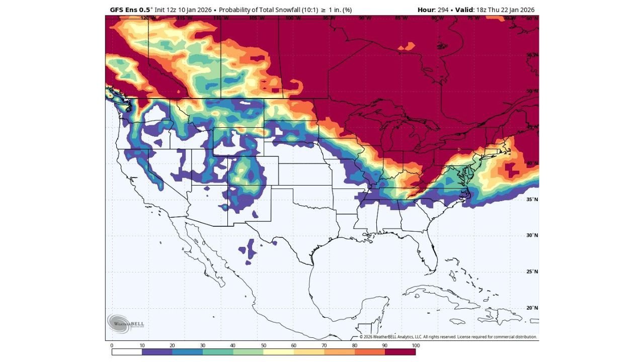
The latest GFS ensemble snowfall probability maps indicate a developing corridor of colder air pressing southward, with moisture overlapping the region during the January 21–23 timeframe. This overlap is what forecasters watch closely when assessing snow potential in the Southeast.
What the Forecast Models Are Showing Right Now
Current ensemble data highlights a band of higher probabilities for at least 1 inch of snow extending from parts of the Southern Plains through the Ohio Valley and brushing the Tennessee Valley. While the highest probabilities remain north of the region, Tennessee Valley locations sit near the southern edge of the snow signal, which is often where forecast uncertainty is highest — and where outcomes can change quickly.
At this stage, the data suggests:
- Cold air may be in place, especially at night
- Moisture could arrive at the right time, increasing winter weather potential
- Snow, a rain-snow mix, or cold rain are all still on the table
Why This Setup Matters for the Tennessee Valley
Snow in the Tennessee Valley is often highly dependent on small temperature changes, sometimes just a few degrees at the surface. The current pattern shows a stronger cold reservoir to the north, and if that cold air pushes slightly farther south than currently modeled, snow chances could increase rapidly.
This is why forecasters stress that this is a signal, not a forecast yet. Still, the repeated appearance of snow potential across multiple ensemble runs makes this worth monitoring.
Timing: Late Week Into Next Weekend
If this system develops as currently hinted:
- The earliest impacts would arrive late next week
- The window for winter weather looks centered around January 22
- Any snow would likely be short-lived but impactful, especially for travel
Because this is a long-range outlook, details such as snowfall totals, exact locations, and precipitation type are far from locked in.
What Residents Should Do Now
There is no need for immediate preparation, but residents across the Tennessee Valley should:
- Stay aware of forecast updates over the next several days
- Be cautious of social media snow maps without context
- Remember that Southeast winter setups can shift rapidly
If colder trends continue in upcoming model runs, confidence will increase — and so will the need for planning.
For now, consider this an early heads-up rather than a certainty. Winter is not done with the Tennessee Valley yet.
Stay with Waldron News as we continue tracking this potential late-January winter weather threat and provide clearer guidance as confidence improves.