
Texas, Louisiana, Mississippi, Alabama, Georgia, Tennessee, Kentucky, Ohio, Pennsylvania, New York, and the Southeast Brace for Spring-Like January Warmth as Hundreds of Temperature Records Face Threat
UNITED STATES — January is about to feel far more like April across large portions of the country as an unusually strong surge of warm air spreads east this week, placing hundreds of temperature records at risk across roughly 35 states and Washington, D.C. Forecast data shows both record-breaking daytime highs and unusually warm overnight lows, a combination rarely seen this widespread in mid-winter.
Meteorologists say the setup will lead to 60s, 70s, and even 80s in parts of the South and East, with some locations pushing into the 90s, while several overnight low records could be broken by more than 10 degrees.
Record-Breaking Warmth Expected Across the Ohio and Mississippi Valleys
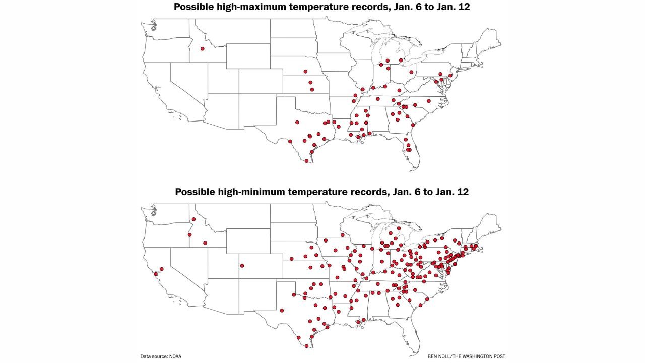
Forecast guidance highlights the Ohio Valley and Mississippi Valley as two of the most active regions for record activity. Cities across Texas, Louisiana, Arkansas, Mississippi, Tennessee, Kentucky, Missouri, Illinois, Indiana, and Ohio are expected to challenge or break both high-maximum and high-minimum temperature records between January 6 and January 12.
In these areas, daytime temperatures are forecast to climb well above seasonal norms, while nighttime temperatures remain unusually mild — preventing the normal overnight cooling that January typically brings.
Northeast and Mid-Atlantic See Unusual January Warmth
The warmth does not stop in the central U.S. Forecast maps show a notable push into the Mid-Atlantic and Northeast, including Pennsylvania, New Jersey, New York, Maryland, Virginia, Massachusetts, and Connecticut.
Several cities in these states may see January highs more typical of early April, with overnight lows remaining so warm that high-minimum records are at particular risk. This means temperatures may fail to drop below the 40s or even 50s overnight in some urban areas.
Why This Warm Pattern Is So Unusual
Meteorologists point to a persistent upper-level ridge dominating much of the eastern half of the United States. This ridge allows warm air from the Gulf of Mexico and southern Plains to surge northward, while colder Arctic air remains bottled up across western Canada and parts of the northern Rockies.
The result is a prolonged stretch of spring-like warmth, rather than a brief temperature spike. Forecast data indicates that this pattern could last several days, increasing the likelihood of widespread record-breaking temperatures.
Potential Impacts: From Early Spring Growth to Energy Shifts
While the warmth may feel pleasant, it comes with potential impacts:
- Early budding and plant growth, increasing vulnerability to future cold snaps
- Reduced winter snowpack in some regions
- Lower heating demand, temporarily easing energy usage
- Increased allergy activity in the South and Southeast
Experts caution that winter is not over, and a return to colder conditions later this month could still pose risks to vegetation that responds too quickly to the warmth.
What to Expect Through the Weekend
Forecast models show the warmest anomalies peaking late this week into the weekend, with the highest concentration of record threats stretching from Texas and the Gulf Coast through the Southeast, Ohio Valley, and into parts of the Northeast.
Residents are encouraged to stay aware of daily forecasts, especially in areas where temperature swings could affect travel, agriculture, or outdoor plans.
Warm January days are becoming more frequent in recent years, but this week’s setup stands out for its scale, duration, and record-breaking potential. What do you think — is this just a winter anomaly, or another sign of changing seasonal patterns? Share your thoughts and follow the latest weather updates on Waldron News.