
Texas, Oklahoma, Arkansas, Mississippi, Alabama, and Georgia Monitor Possible Late-Week Severe Weather as Forecast Confidence Remains Low
UNITED STATES — Forecasters are monitoring a potential increase in severe weather risk by the end of the coming week across parts of Texas, Oklahoma, Arkansas, Mississippi, Alabama, and Georgia, though officials stress that forecast confidence remains low due to ongoing model inconsistencies.
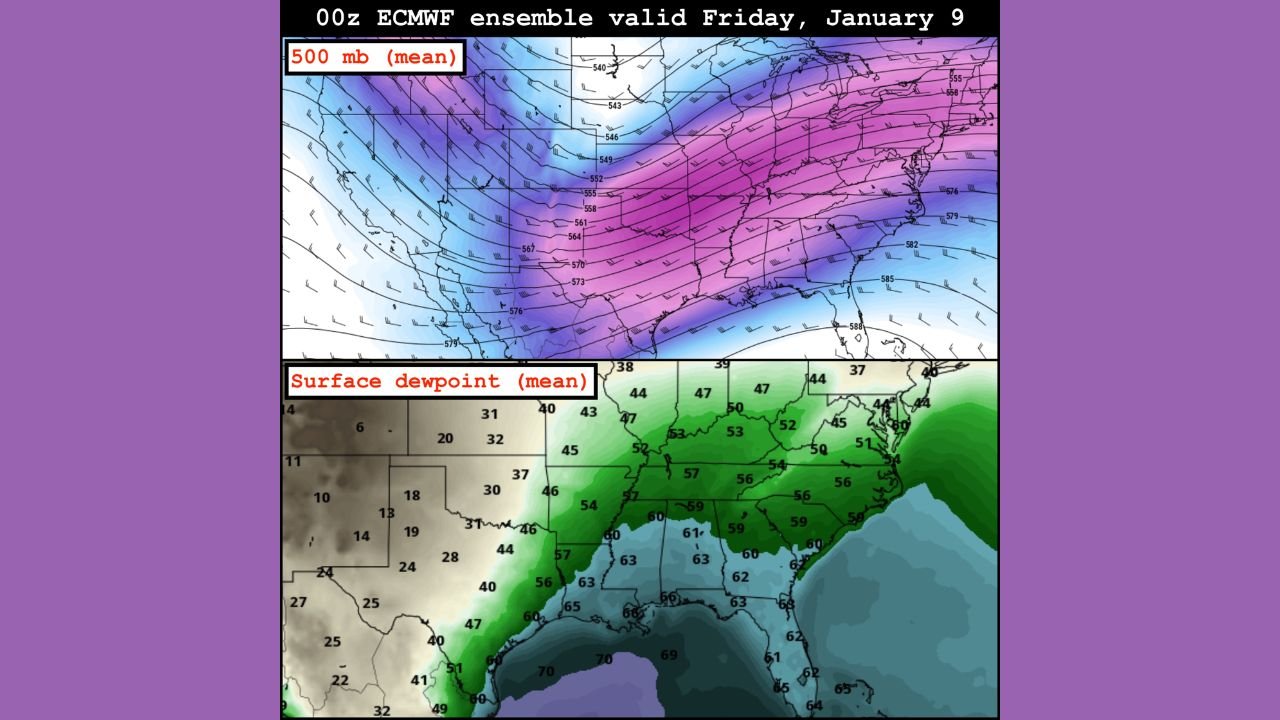
Long-range ensemble guidance suggests a more active upper-level pattern may begin to develop from the Southern Plains into the Mid-South and Southeast, but meteorologists caution that details regarding timing, coverage, and severity are still uncertain.
What the Current Forecast Signals Show
Ensemble model data indicates the possibility of a strengthening jet stream over the central and southern United States later this week. This pattern could allow seasonally rich Gulf moisture to return northward into the Southern Plains and Southeast.
When combined, these ingredients can sometimes support organized thunderstorm development, including the potential for strong or severe storms. However, at this stage, the signals remain broad and non-specific, meaning no particular outbreak scenario is being indicated.
Why Confidence Is Still Low Right Now
Meteorologists emphasize that there is significant run-to-run and model-to-model inconsistency in the forecast data. While some ensemble members show a more favorable setup for severe weather, others depict a much weaker or delayed system.
This level of disagreement limits confidence in:
- Storm intensity
- Exact timing
- Which states may see the greatest impact
As a result, forecasters are advising the public not to rely on individual or deterministic model runs, especially those circulating on social media that may exaggerate potential outcomes.
Areas Being Closely Watched
At this time, the general region of interest includes:
- North and Central Texas
- Oklahoma
- Arkansas
- Mississippi
- Alabama
- Georgia
Any potential severe weather threat would most likely occur late in the week, but this could shift earlier or later as newer data becomes available.
What This Does — and Does Not — Mean
It is important to clarify that:
- No severe weather outbreak is currently forecast
- No watches or warnings are in effect
- Specific hazards such as tornadoes or damaging winds are not yet defined
This forecast simply reflects an environmental pattern that bears monitoring, not a confirmed high-impact event.
What Residents Should Do Now
Residents across the affected states are encouraged to:
- Stay updated with official forecast updates
- Avoid sharing or reacting to single-model or clickbait projections
- Understand that changes are likely over the coming days
Forecast clarity is expected to improve as the potential system moves closer in time and higher-resolution data becomes available.
While there are early signs of a more active weather pattern developing across Texas, Oklahoma, Arkansas, Mississippi, Alabama, and Georgia, uncertainty remains high, and confidence in any specific severe weather outcome is currently limited.
Meteorologists will continue to monitor the evolving setup, and residents are advised to stay informed as the forecast becomes clearer later this week.