
Three Day Storm Siege Targets Great Lakes and Midwest as Active Radar Pattern Rolls Through Minnesota, Wisconsin, Michigan, Illinois and Indiana From Monday Night Through Wednesday
CHICAGO, Illinois — A high-resolution look at the storm pattern unfolding across the Great Lakes and Midwest from Monday, April 13 through Wednesday, April 15 reveals a relentless three-day severe weather siege that begins in the Upper Midwest Monday evening and progressively spreads south and east through Wisconsin, Michigan, Illinois, Indiana, and Iowa as the days advance — with intense storm cells, heavy rainfall, and severe weather potential showing up at virtually every time step across the region.
The Great Lakes region is the main target to start this pattern, but the storm activity is expected to spread southward as the days go on — meaning communities from Minneapolis and Green Bay on Monday through Chicago, Detroit, Indianapolis, and Cedar Rapids by Wednesday are all in the path of what is shaping up as one of the most sustained and widespread storm sequences the Midwest has seen this spring.
Hour by Hour — What the Simulated Radar Shows
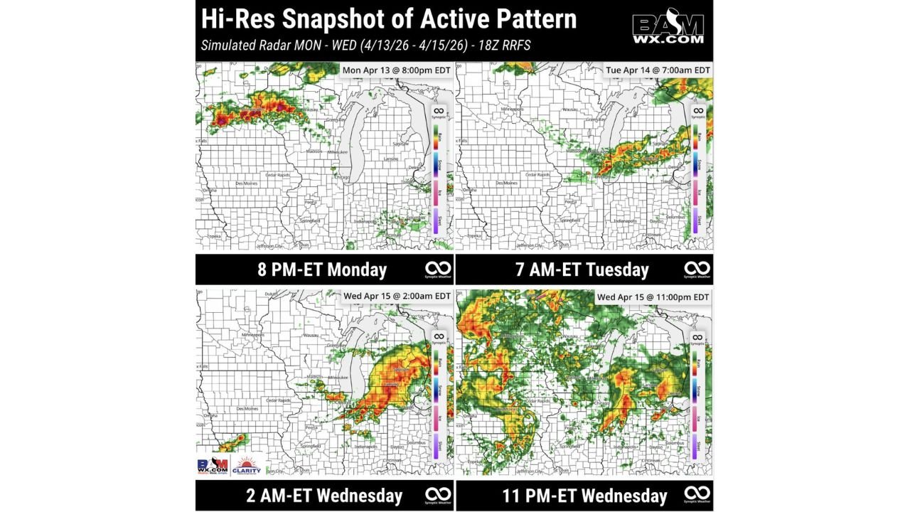
Monday, April 13 at 8:00 PM EDT — Upper Midwest Erupts: The opening frame of this three-day sequence shows intense storm activity already fully developed and tracking across the Minnesota-Wisconsin corridor by Monday evening. Deep red and orange storm cores are visible across the region with the heaviest activity concentrated across southern Minnesota, western Wisconsin, and the Green Bay corridor. This is the supercell window — the evening hours Monday when rotating storms are most likely to be producing large hail and tornadoes across the Twin Cities and surrounding communities. Chicago, Cedar Rapids, and Des Moines are on the edge of activity but the main energy Monday night is clearly focused on the Upper Midwest.
Tuesday, April 14 at 7:00 AM EDT — Storms Push East Overnight: By Tuesday morning, the storm corridor has shifted dramatically eastward. The simulated radar for 7 AM Tuesday shows an active and intense line of storms stretching from Minneapolis eastward through Green Bay, Saginaw, and Detroit — meaning the overnight hours between Monday and Tuesday will bring significant storm activity to communities across Wisconsin, Michigan, and the northern Great Lakes that may have been on the edge of Monday evening’s event. This is an important signal for residents in Detroit, Saginaw, and Lansing — the storm threat does not end Monday night, it continues and evolves through Tuesday morning.
Wednesday, April 15 at 2:00 AM EDT — Illinois and Indiana Take the Hit: The early Wednesday morning frame shows the storm corridor has dropped significantly southward by the middle of the week. Intense storm activity is now centered over Illinois, Indiana, and the Chicago metro area with orange and red cores indicating the most active convection. Madison, Milwaukee, Chicago, Indianapolis, and Dayton are all in the path of what appears to be a well-organized and intense storm system pushing through the region in the pre-dawn hours of Wednesday. Residents across northern Illinois and Indiana who may have missed the worst of Monday and Tuesday’s storms are directly in the Wednesday early morning threat window.
Wednesday, April 15 at 11:00 PM EDT — Southern Spread Continues: The final frame of this three-day sequence shows the storm activity pushing further south and east by Wednesday evening — with intense cells now visible across a corridor stretching from Minneapolis south through Cedar Rapids, Iowa, into Illinois and Indiana while a separate area of activity continues pushing east through the Great Lakes. By Wednesday night the pattern is showing storm coverage across an enormous geographic area from the Upper Midwest all the way through the Ohio Valley — with Cedar Rapids, Peoria, Indianapolis, Columbus, and Dayton all within the active storm zone.
The Big Picture — Why This Three Day Pattern Is Unusually Active
What makes this Monday through Wednesday storm sequence stand out is not just the severity of individual days but the continuous and evolving nature of the storm coverage across the entire Great Lakes and Midwest region. The pattern is not delivering one discrete event — it is delivering a rolling, progressive storm siege that follows communities from west to east and north to south across the region over 72 hours.
The Great Lakes serve as the initial anchor for this pattern — the warm lake waters and the atmospheric boundaries that form near the lake shores create focusing zones for intense convection that keep storm activity anchored and organized even as individual systems move through. As the upper-level pattern evolves through the week, the energy progressively spreads south into Illinois, Indiana, and Iowa — ensuring that virtually every community from Minneapolis to Indianapolis has at least one significant storm window during the three-day period.
Which Communities Face the Greatest Cumulative Risk
Given the three-day progressive nature of this pattern, here is how the risk distributes across the region:
Monday Evening Primary Targets: Minneapolis, St. Paul, Green Bay, Wausau, Madison — supercell and tornado window during the Monday 8 PM timeframe
Tuesday Morning Transition Zone: Detroit, Saginaw, Lansing, Milwaukee, Green Bay — overnight storm activity pushing east through the Great Lakes Tuesday morning
Wednesday Pre-Dawn Highest Risk: Chicago, Madison, Milwaukee, Indianapolis, Dayton — intense storm cores moving through Illinois and Indiana in the 2 AM Wednesday window when most residents will be asleep
Wednesday Evening Spreading South: Cedar Rapids, Peoria, Indianapolis, Columbus — the final southward push of storm activity Wednesday night completing the three-day siege
What Residents Across the Great Lakes and Midwest Must Do
- Monday evening — Minnesota and Wisconsin residents must be sheltered and weather-aware before 8 PM EDT as the most intense storm activity is already fully developed by that hour
- Tuesday morning — Detroit, Saginaw, and northern Michigan residents should not assume Monday’s storm activity means Tuesday is clear — the 7 AM storm line pushes directly through the Great Lakes Tuesday morning
- Wednesday 2 AM is a particularly dangerous window for Chicago and Indianapolis — overnight severe weather when residents are asleep requires active weather alerts on phones set to override Do Not Disturb mode
- Every community from Minneapolis to Indianapolis should have shelter plans confirmed and weather alerts active before Monday afternoon since the three-day pattern begins immediately
- Wednesday evening residents across Cedar Rapids, Peoria, and Columbus should treat Wednesday as their primary severe weather day as the southward spread of storm activity reaches its furthest extent
From Monday night through Wednesday night, the Great Lakes and Midwest are entering one of the most sustained and geographically broad storm sequences of the spring season. The pattern is progressive, it is persistent, and it will affect different communities at different times — meaning there is no single safe window for any community between Minneapolis and Indianapolis during this three-day period.
WaldronNews.com will continue tracking this three-day storm siege across Minnesota, Wisconsin, Michigan, Illinois, Indiana, and Iowa and will provide updates as each round of storms develops and moves through the region.