
Tornado-Capable Storms Target the Midwest Monday as Cold and Warm Front Collision Raises Serious Concerns Across the Plains
Chicago, IL — A dangerous and fast-evolving severe weather setup is taking shape for Monday, April 13, as a colliding cold front and warm front create the conditions needed to spawn powerful thunderstorms capable of producing tornadoes across the Midwest, while isolated supercells threaten further south across the Plains if a stubborn atmospheric cap breaks down during the afternoon.
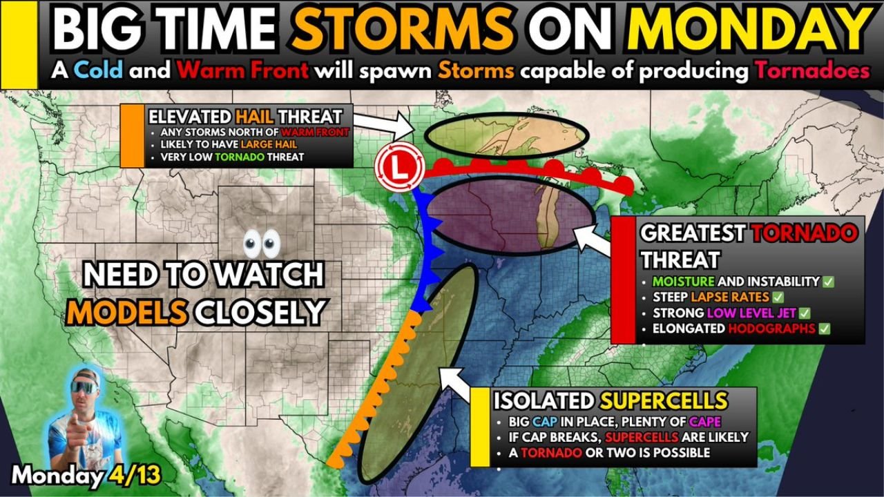
Forecasters are urging close attention to model trends heading into Monday, warning that this setup could easily trend more dangerous — or less — as the day approaches, making it one of the more uncertain but potentially significant severe weather events of the early spring season.
States and Regions in the Risk Zone
- Midwest: The primary zone of concern Monday — greatest tornado threat is focused here where all atmospheric ingredients are aligning
- Southern Plains: A conditional severe threat exists further south where an isolated supercell or two could fire if the atmospheric cap breaks, bringing all hazards including tornadoes
- North of the Warm Front: An elevated hail threat exists for any storms that develop north of the warm front boundary, with large hail likely but tornado threat remaining very low in that zone
Primary Threats
Monday’s setup is dangerous because multiple atmospheric ingredients are stacking on top of each other simultaneously across the Midwest:
- Cold and Warm Front collision — The meeting of these two boundaries is the main storm trigger Monday, providing the lift needed to fire thunderstorms capable of rotating and producing tornadoes
- Ample low-level moisture — Deep moisture is surging into the region at the surface, providing the fuel that thunderstorms need to grow tall and intense quickly
- High storm fuel (CAPE) — Plenty of atmospheric instability is in place, meaning storms that do develop will have abundant energy to work with and can become severe rapidly
- Elongated hodographs — This is a measure of how wind direction and speed change with height in the atmosphere. Elongated hodographs mean the atmosphere has a significant twist to it — the exact ingredient that allows thunderstorms to rotate and produce tornadoes
- Strengthening low-level jet — A powerful ribbon of fast-moving wind near the surface is forecast to strengthen through Monday, further enhancing the tornado threat by adding additional spin to developing storms
- Storm mode remains a question — The biggest uncertainty right now is how storms will organize. If they stay discrete and separate, tornado threat goes up significantly. If they merge into a line, the tornado threat drops but wind damage becomes the bigger concern
Why This Matters for the Midwest
The Midwest is staring at a textbook tornado-producing setup for Monday. When forecasters see moisture, instability, steep lapse rates, a strong low-level jet, and elongated hodographs all checking off together, that is not a casual spring storm — that is an environment where long-track, violent tornadoes become a real possibility.
What makes this particular setup stand out is the sheer number of ingredients that are already confirmed in place. A Cold Front and Warm Front working together to initiate storms, plenty of storm fuel in the atmosphere, and a strengthening low-level jet providing the spin and organization that separates ordinary thunderstorms from dangerous rotating supercells.
The single biggest question that forecasters are still wrestling with heading into Monday is storm mode — meaning how individual storms will organize once they develop. This one factor could be the difference between a widespread tornado outbreak and a primarily wind and hail event. That answer will become clearer as Monday gets closer and model data sharpens.
Threat Further South on the Plains
Further south on the Plains, the picture is different but still dangerous under the right conditions. A massive atmospheric cap is sitting in place across this region — think of it like a lid on a pot, suppressing storm development and keeping things quiet. However, if that cap breaks during peak afternoon heating on Monday, isolated supercells are likely to fire quickly, and these storms would have access to plenty of CAPE and all severe hazards, including the possibility of a tornado or two.
The southern threat is described as conditional — meaning it depends entirely on whether the cap breaks. But if it does, the storms that develop could be significant and difficult to warn for given how quickly they may form and intensify.
Multi-Day Pattern
Monday is shaping up as the focal point of this severe weather sequence. Forecasters are clear that models need to be watched closely between now and Monday morning, as this setup has the potential to trend upward into a more significant outbreak or trend downward if storm mode does not cooperate.
The tornado threat is most concentrated in the Midwest where all ingredients are aligned, while the Southern Plains remain on a conditional watch pending cap breakdown. Either way, residents across both regions should be treating Monday as a serious weather day and preparing now rather than waiting for watches and warnings to be issued.
What to Watch Next
- Monitor whether storm mode forecasts trend toward discrete supercells — this is the single factor that most determines how serious Monday becomes
- Watch for SPC to issue Moderate or High risk designations for the Midwest as Monday morning approaches and model data firms up
- Residents across the Midwest tornado threat zone should identify their nearest shelter and have it ready before Monday afternoon
- Southern Plains residents should watch afternoon temperatures closely — cap break timing will determine whether supercells fire and how quickly
- Have a NOAA Weather Radio or reliable weather app with push alerts active all day Monday — storms in these setups can produce tornadoes with very little warning time
- Check back for updates as models are expected to trend significantly in one direction or the other before Monday arrives
Across the Midwest and Southern Plains, Monday is a day to take seriously. The atmosphere is loaded, the ingredients are in place, and the only remaining question is how it all comes together. Residents are urged to stay weather-aware, have a shelter plan ready, and never wait for a tornado to be on the ground before seeking safety.
WaldronNews.com will continue tracking this dangerous Monday severe weather setup and will provide updates as model trends and storm mode questions become clearer ahead of the event.