
Tornado Threat Emerging Across Missouri Bootheel and Western Kentucky as Rotating Storms Could Develop Near Interstate 64
MISSOURI BOOTHEEL — Forecasters are monitoring a potential severe weather setup developing across the Missouri Bootheel, western Kentucky, and nearby sections of southern Illinois, where atmospheric conditions could allow isolated rotating thunderstorms and possible tornado warnings to develop.
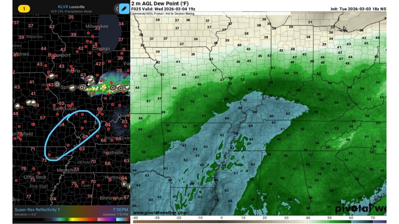
Weather analysis suggests the environment may support a few severe storms along a developing boundary, particularly across southeast Missouri and western Kentucky, with additional activity possible along the Interstate 64 corridor across southern Illinois.
Storm Development Possible Along Regional Boundary
Meteorologists say the storm risk is tied to a boundary separating cooler northern air from warmer, more humid air to the south, creating a zone where thunderstorms could strengthen.
Areas most likely to see storms include:
- Missouri Bootheel
- Western Kentucky
- Southern Illinois
- Communities along Interstate 64
Cities within the potential impact zone include:
- Cape Girardeau, Missouri
- Paducah, Kentucky
- Carbondale, Illinois
- Jonesboro, Arkansas (near the southern edge of the risk)
Radar simulations indicate scattered storm cells may develop near this boundary during the afternoon or evening.
Rotating Storm Cells Could Produce Severe Warnings
Meteorologists note that while the setup is conditional, the atmosphere may support a couple of rotating storm cells, which could briefly produce tornado warnings.
Potential hazards from these storms include:
- Strong wind gusts
- Localized hail
- Isolated tornado potential
Storm coverage is expected to remain limited rather than widespread, meaning only a few communities may experience severe weather.
Moisture and Temperature Gradient Increasing Instability
Atmospheric data shows a strong dew point gradient across the region, which can help fuel storm development.
The latest model projections show:
- Dew points in the 60s across Arkansas and western Kentucky
- Lower 40s across Illinois and northern Missouri
This contrast between warm, moist air and cooler air north of the boundary creates an environment supportive of thunderstorms capable of rotation.
The greatest instability appears focused across southeast Missouri and western Kentucky, aligning with the area most likely to see stronger storms.
Storm Timing and Coverage Still Uncertain
Forecast confidence remains moderate, with meteorologists emphasizing that the severe weather risk is conditional and dependent on whether storms are able to develop along the boundary.
If storms do form, however, a few severe warnings appear likely somewhere within the highlighted region, particularly across the Missouri Bootheel and western Kentucky.
Residents across southern Illinois, southeast Missouri, and western Kentucky are encouraged to stay alert to forecast updates and weather alerts throughout the day.
Stay with WaldronNews.com for the latest severe weather tracking, radar updates, and storm coverage as this potential severe weather event develops across the Midwest and Lower Mississippi Valley.