
Virginia, North Carolina, Maryland, Delaware, and New Jersey See Growing January 15–16 East Coast Winter Storm Signal as Models Align on Coastal Low
VIRGINIA — Forecast confidence is increasing that a coastal winter storm could impact portions of the East Coast around January 15–16, as multiple forecast models continue to signal the development of a surface low near the Mid-Atlantic coastline. While important details such as snowfall amounts and exact track remain uncertain, meteorologists note that the overall signal has strengthened significantly within the six-day window.
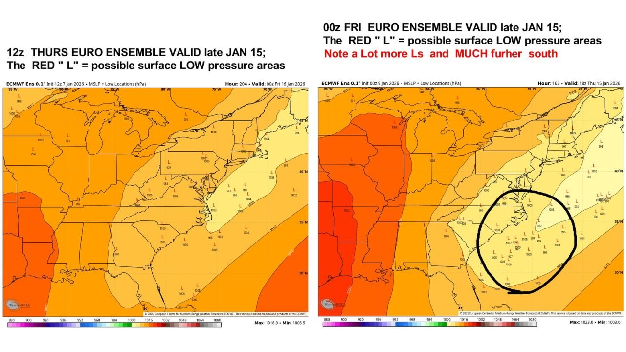
Recent European and GFS guidance suggests the storm would primarily affect North Carolina, Virginia, and the Delmarva region, with impacts potentially extending northward toward New Jersey depending on how the system evolves.
Why the January 15–16 Window Matters
The current forecast timeframe is now inside six days, a range where large-scale pattern signals typically become more reliable. Forecasters emphasize that this is no longer a long-range or speculative setup, even though fine details remain unresolved.
Both the 12z operational GFS and 12z operational European models show a developing coastal low during this period, reinforcing confidence that some form of organized winter weather system is likely.
Strong Signal, Unclear Details
While confidence has increased in the presence of a storm, specific impacts are still highly uncertain. Forecast guidance continues to show variability in:
- Exact storm track
- Strength of the surface low
- Placement of the rain–snow line
- Duration of precipitation
Small changes in these factors could determine whether areas see significant snowfall, mixed precipitation, or mostly rain, particularly along the Interstate 95 corridor.
Potential Miller A–Type Coastal Storm Setup
Ensemble guidance suggests a classic Miller A–type winter storm structure is possible, characterized by a strong coastal low forming along the East Coast and drawing cold air into the system from the north and west.
The evolution of a key shortwave disturbance upstream will play a critical role. Depending on how that energy phases with the coastal low, the storm could:
- Track closer to the coast, increasing snow potential inland
- Shift offshore, limiting impacts
- Strengthen rapidly if phasing occurs at the right time
January 18–19 Also Worth Monitoring
In addition to the January 15–16 window, forecasters are also monitoring January 18–19 for continued winter weather potential. Ensemble data shows multiple low-pressure signals during that period, suggesting the broader pattern may remain active even after the initial storm threat passes.
This reinforces the idea that mid-January could feature multiple weather systems, not just a single event.
What This Means for the East Coast
Residents across Virginia, North Carolina, Maryland, Delaware, New Jersey, and nearby states should be prepared for forecast changes over the coming days. While it is too early to lock in specific impacts, the setup supports increasing winter weather risk, especially if cold air remains in place as the coastal low develops.
Travel plans, outdoor events, and infrastructure operations during the January 15–16 timeframe should be monitored closely as newer data becomes available.
Waldron will continue tracking this developing East Coast winter storm threat and provide updates as confidence increases and details become clearer.