
Virginia, Pennsylvania, New York, New Jersey, Maryland, Ohio: Blizzard of 1996 Marked One of the Most Widespread and Historic Snowstorms in U.S. History
UNITED STATES — The Blizzard of January 6–8, 1996, remembered simply as the Blizzard of ’96, remains one of the most intense and far-reaching winter storms ever recorded across the eastern United States. The storm struck some of the most densely populated regions in the country, delivering crippling snowfall from the Ohio Valley through the Mid-Atlantic and into New England, effectively shutting down major cities along the I-95 corridor.
How the Blizzard of 1996 Developed
The historic storm formed as a powerful low-pressure system tracked up the East Coast, drawing deep Atlantic moisture into a surge of Arctic air already entrenched across the region. This setup allowed snow to fall rapidly and continuously for more than 24 hours in many areas. Strong winds intensified conditions, producing blizzard criteria with near-zero visibility across wide swaths of the Mid-Atlantic and Northeast.
Snowfall rates frequently exceeded 2 to 4 inches per hour, overwhelming road crews and emergency services as conditions deteriorated faster than expected.
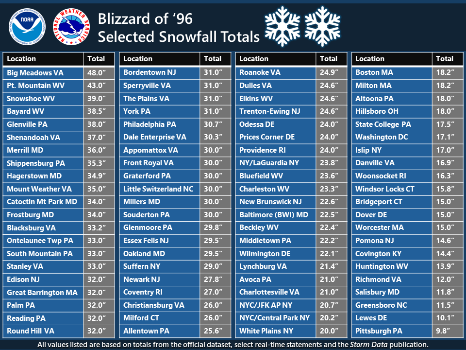
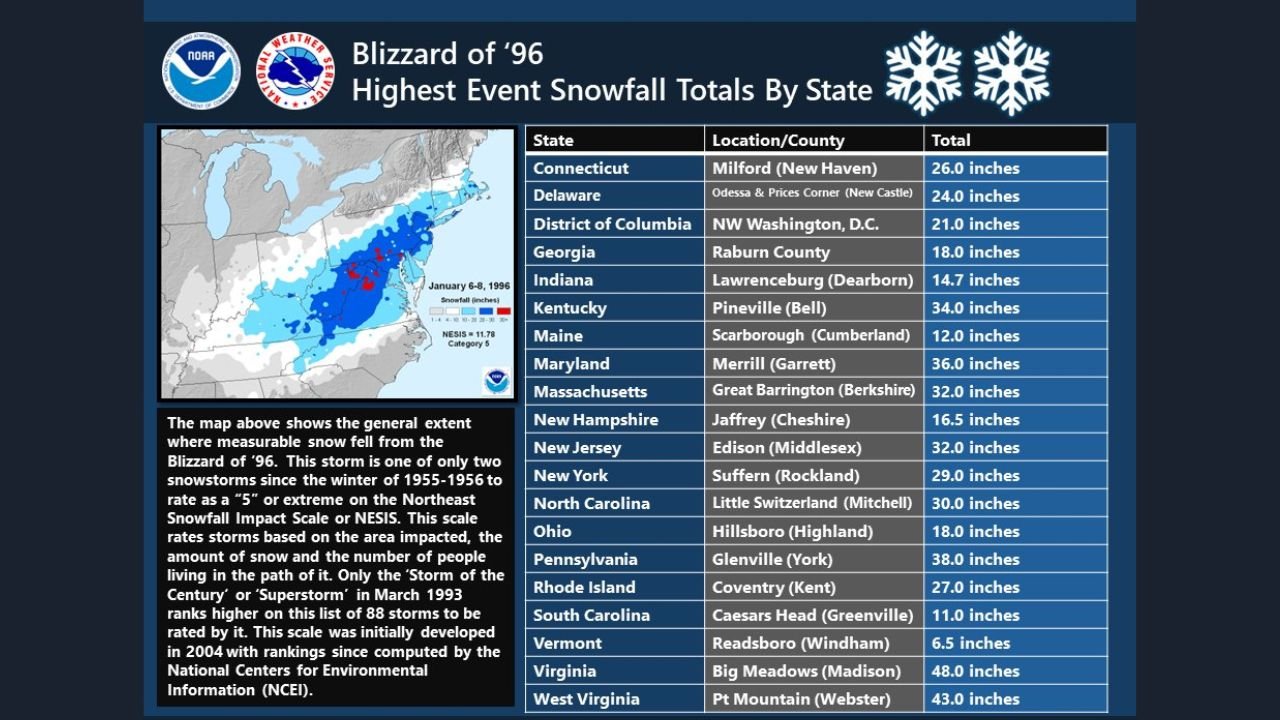
The Blizzard of ’96 produced staggering snowfall totals that remain benchmarks decades later. Some of the highest reported amounts included:
- Virginia: Up to 48 inches at Big Meadows
- West Virginia: Over 43 inches in mountainous regions
- Pennsylvania: As much as 38 inches, including York County
- New Jersey: Widespread 30–32 inches
- New York: Nearly 30 inches in Rockland County, with Central Park exceeding 20 inches
- Maryland and Washington, D.C.: More than 20 inches in many locations
- Ohio: Totals nearing 18 inches in southern counties
Few storms in U.S. history have delivered this level of snowfall across such a large and heavily populated area simultaneously.
Why the Blizzard of ’96 Was So Disruptive
What made the storm especially devastating was not only the snow depth, but where it fell. Major metropolitan areas including Philadelphia, New York City, Baltimore, and Washington, D.C., were paralyzed. Airports shut down, interstate highways became impassable, and public transit systems were suspended for days.
In the storm’s aftermath, a rapid temperature rise led to widespread snowmelt and flooding, particularly across Pennsylvania, Virginia, and New York, compounding the disaster and prolonging recovery efforts well beyond the snowfall itself.
The Blizzard’s Lasting Impact on Weather History
Meteorologists continue to reference the Blizzard of 1996 as a defining example of how large-scale atmospheric patterns can align to produce extreme winter weather. It is frequently compared to modern storm threats when deep troughs, strong jet stream energy, and coastal development appear in forecast models.
The storm also helped shape improvements in winter weather forecasting, emergency preparedness, and public awareness of high-impact snow events across the eastern United States.
Why the Blizzard of 1996 Still Matters Today
Nearly three decades later, the Blizzard of ’96 remains a reminder that historic winter storms are not rare anomalies. When atmospheric conditions align correctly, the eastern U.S. can still experience crippling snowstorms capable of shutting down entire regions in a matter of hours.
Did the Blizzard of 1996 impact your area, or do you remember how communities handled the storm? Share your experience and continue following winter weather history and analysis with Waldron News.