
Washington DC, Pennsylvania, New York, and New England Could See Major Winter Storm Late Next Week as GFS Hints at High-End Scenario, Confidence Still Low
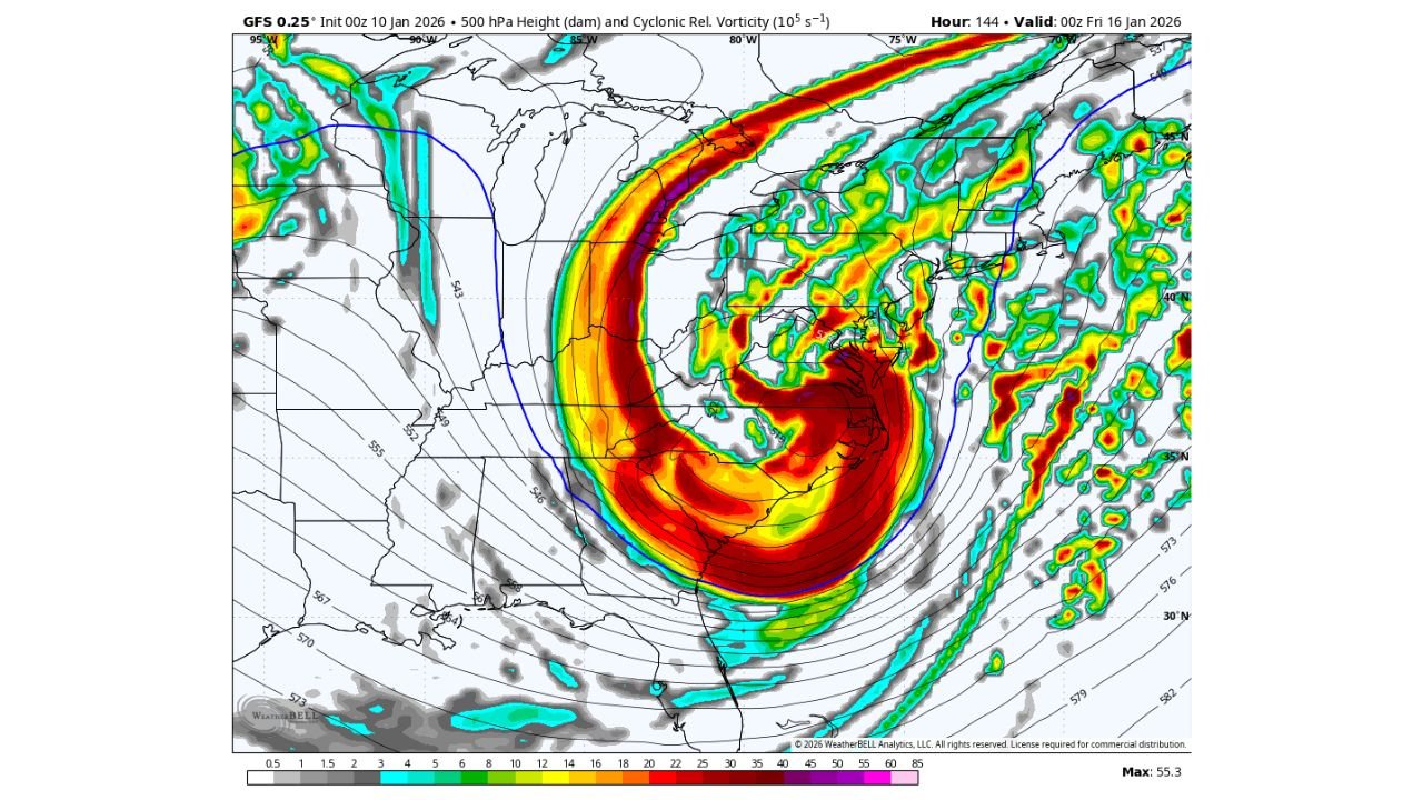
UNITED STATES — Forecast models are beginning to flag the potential for a significant Mid-Atlantic to New England winter storm late next week, but meteorologists caution that the setup is far from a lock and highly sensitive to timing and storm-track details. Recent GFS model runs are advertising a high-end, low-probability scenario involving a large, powerful storm system that could impact Washington DC, Pennsylvania, New York, and parts of New England toward Thursday into Friday.
Why the GFS Is Getting Attention
The GFS is depicting a rare, high-impact setup, featuring a triple-phased system in which multiple pieces of energy combine into a deep low-pressure system along or just off the East Coast. In its most aggressive solutions, this would be the type of storm capable of producing widespread heavy snow and strong winds from the Mid-Atlantic northward.
This type of storm does not happen often — and when it does, everything must align perfectly.
Why This Is Still Not a Forecast
Despite eye-catching maps, forecasters stress that high-end snowstorms for DC, Philadelphia, and New York are notoriously difficult to pin down at this range. Even small changes in:
- When upper-level energy phases
- Where the surface low develops
- How quickly the storm intensifies
can mean the difference between a major snowstorm, a glancing blow, or a system that stays mostly offshore.
Some model guidance, including European solutions, keeps the storm later and farther east, limiting impacts to coastal or offshore areas.
What the Ensembles Are Saying
While deterministic runs vary widely, GFS ensemble guidance does add some credibility to the idea that a sizable low-pressure system may form somewhere near the East Coast late next week. The biggest unknown remains where and when the energy consolidates.
That timing question is critical — especially for snow lovers in DC, Philadelphia, and New York City, where marginal setups can quickly turn into rain, mixed precipitation, or nothing at all if the storm strengthens too late.
Timing to Watch
If this system were to materialize in a meaningful way, the current window of concern would be:
- Thursday into Friday late next week
- Primary focus from the Mid-Atlantic into New England
This timeframe will sharpen significantly over the next several days as models resolve how upstream energy evolves.
Bottom Line
This is absolutely a storm worth watching, especially given how long it has been since DC, Philadelphia, and New York City all shared a major snowstorm. However, this remains a low-confidence, high-impact scenario, and residents should avoid locking in expectations based on any single model run.
The signal right now is possibility — not probability.
Stay with Waldron for continued updates as confidence improves and the late-week winter storm potential becomes clearer.