
West Virginia and Virginia Allegheny Mountains Could See Rare, Potentially Historic Wind Event With 75–100 MPH Gusts Late Monday, Forecast Models Show
WEST VIRGINIA & VIRGINIA — Forecast models are indicating an exceptionally rare and dangerous wind event across the Allegheny Mountains, with potential wind gusts ranging from 75 to 100 mph late Monday into early Tuesday, according to high-end ensemble guidance.
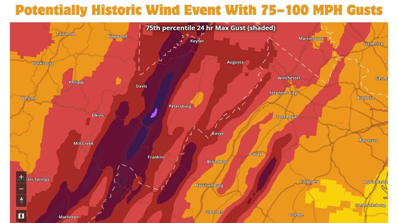
Meteorologists reviewing the National Blend of Models (NBM) say the signal showing up for the Allegheny region is one of the strongest ever observed, raising serious concerns for widespread power outages, extensive tree damage, and structural impacts, especially in higher elevations.
Why This Wind Signal Is Setting Off Alarms
The concern is not based on a single model run — it is coming from multiple percentiles lining up at extreme levels:
- NBM mean max gusts: 75–90 mph
- 75th percentile max gusts: 90–100 mph
- Even the 25th percentile: near 80 mph
Forecasters note that it is extremely unusual for every percentile to remain this high, especially for the Allegheny Mountains, where terrain already enhances wind speeds.
Areas Most At Risk
The highest risk is focused along and west of the Allegheny Front, including:
- Eastern West Virginia mountain counties
- Western and northwestern Virginia, including parts of the Shenandoah region
- Exposed ridgetops and high-elevation communities, where winds can accelerate rapidly
Valleys may still experience damaging winds, but ridge-level gusts could reach destructive levels.
Timing: When the Worst Winds Are Expected
Based on current guidance:
- Winds rapidly increase: Late Monday afternoon
- Peak extreme gusts: Monday night into early Tuesday
- Gradual weakening: Tuesday afternoon
The overnight timing significantly increases risk, as falling trees and power lines could occur while many residents are asleep.
Potential Impacts If Forecast Verifies
If these projections materialize, impacts could include:
- Widespread, long-duration power outages
- Downed trees and snapped utility poles
- Roof and structural damage to homes, barns, and outbuildings
- Blocked roads across mountainous terrain
- Dangerous conditions for emergency crews and utility workers
Wind speeds of this magnitude approach hurricane-force conditions, particularly along exposed ridges.
Why This Is Not a Typical Wind Event
This is not thunderstorm-driven. Instead, it is being fueled by:
- An extremely strong pressure gradient
- Powerful low- and mid-level jet winds
- Efficient cold-season vertical mixing
- Terrain amplification along the Allegheny ridges
These factors allow very strong winds aloft to transfer directly to the surface, even without heavy rain or lightning.
What Residents Should Do Now
People in the Allegheny region should prepare immediately:
- Secure or remove loose outdoor items
- Fully charge phones, power banks, and backup batteries
- Prepare for extended power outages
- Avoid travel during peak wind hours if possible
- Stay away from windows and large trees overnight
High Wind Warnings or potentially rare wind alerts may be issued as confidence continues to increase.
Bottom Line
Forecast data is signaling a rare and potentially historic damaging wind event across the Allegheny Mountains of West Virginia and Virginia, with possible gusts of 75–100 mph late Monday into Tuesday. If realized, impacts could be severe and widespread, particularly in high-elevation areas.