
10 Percent Hatched Tornado Risk Issued for Eastern Iowa, Northern Illinois and Southern Wisconsin as Dangerous Long Track Tornado Setup Unfolds This Afternoon and Evening
CHICAGO, Illinois — A dangerous tornado setup is unfolding right now across the Midwest as a formal 10% hatched tornado risk — CIG2 designation has been issued for a focused corridor centered on eastern Iowa, northern Illinois, and southern Wisconsin — a signal that conditions may support strong, potentially long-track tornadoes during the late afternoon and evening hours today, Tuesday, April 14, 2026.
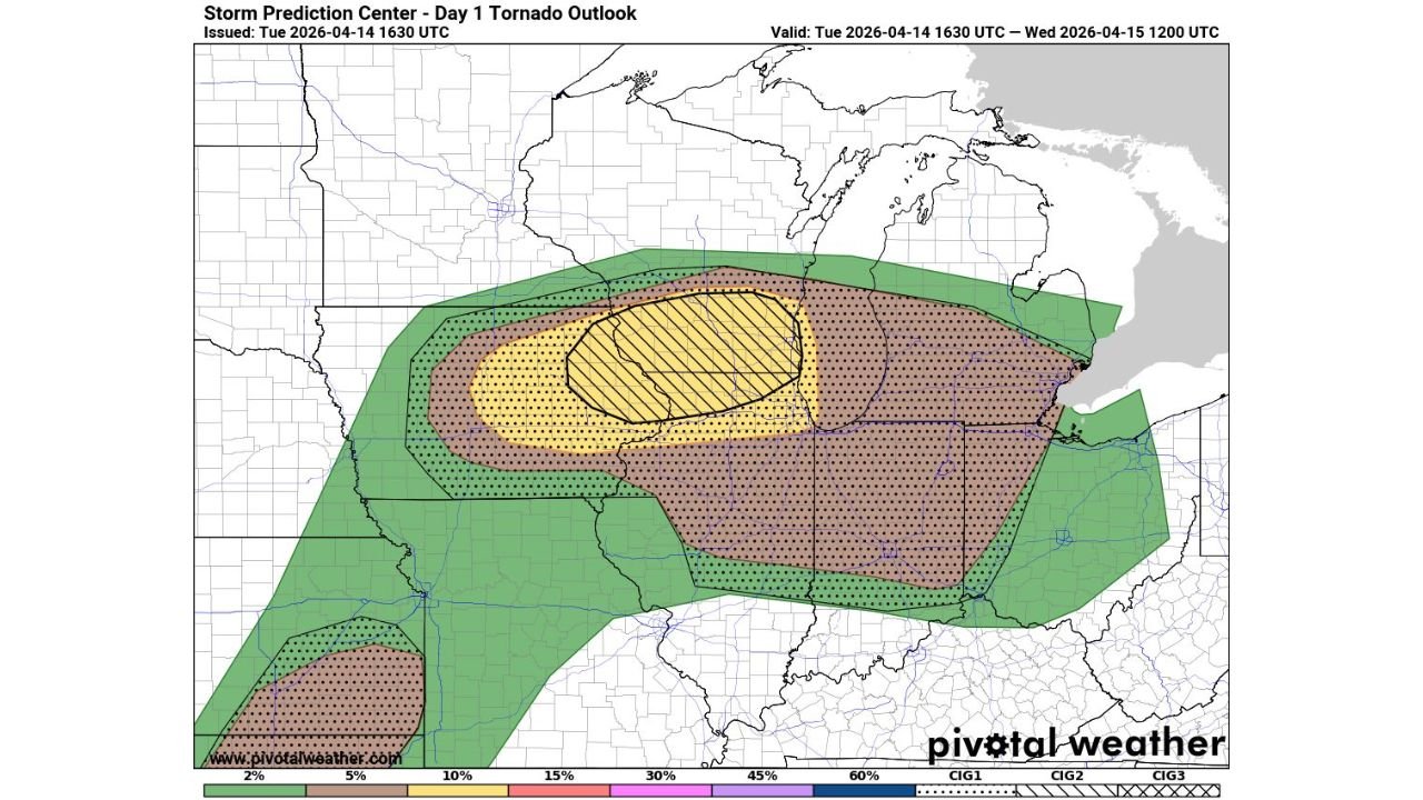
The Day 1 Tornado Outlook issued at 1630 UTC Tuesday and valid through Wednesday, April 15 at 1200 UTC shows a clearly escalating and well-defined risk structure across the Midwest — with the hatched yellow zone covering the most dangerous corridor explicitly identifying eastern Iowa through northern Illinois and southern Wisconsin as the area where long-track tornado potential is greatest this afternoon and evening.
Understanding the Risk Zones — What Each Level Means
The tornado outlook map shows four distinct and escalating levels of tornado probability across the Midwest:
10% Hatched Zone — CIG2 — The Highest Risk Corridor: The yellow hatched oval — the most serious designation on today’s map — is centered directly over eastern Iowa, northern Illinois, and southern Wisconsin. The 10% hatched designation means there is a 10% or greater probability of a tornado within 25 miles of any point in this zone — and the hatching specifically indicates that strong, long-track tornadoes of EF2 or greater intensity are possible. The CIG2 designation confirms this is not a marginal event but a significant, organized tornado threat. Communities sitting inside this hatched yellow oval include the Dubuque, Iowa corridor through Galena and Freeport, Illinois into the southern Wisconsin communities near the state border.
30% Dotted Zone — CIG1 — Broad Significant Risk: The pink dotted zone surrounds the yellow core and covers an enormous area stretching from eastern Nebraska and western Iowa in the west through central Illinois, Indiana, and into the Ohio Valley in the east. A 30% tornado probability across this broad corridor means roughly one-in-three odds of tornado occurrence within 25 miles of any point — a genuinely dangerous level of risk for communities across this entire zone. This pink area covers Iowa City, Cedar Rapids, Davenport, Quad Cities, Chicago, Rockford, Milwaukee, Madison, Fort Wayne, and Indianapolis.
15% Zone — Outer Risk: The broader dotted area extending beyond the pink zone reaches into Minnesota, Wisconsin, Michigan, Ohio, Kentucky, Missouri, Kansas, and Oklahoma — confirming that today’s tornado threat is not limited to the highest-risk corridor but extends across an extraordinarily wide geographic area.
Separate Southern Risk Zone: A distinct and separate 10%+ dotted zone is visible in the lower left of the map — covering portions of Oklahoma and Texas — confirming that today’s tornado threat is simultaneously active across both the Midwest corridor and the Southern Plains, making this one of the most geographically broad tornado outbreak days of 2026.
Why Eastern Iowa, Northern Illinois and Southern Wisconsin Are the Bullseye
The 10% hatched CIG2 zone covering eastern Iowa through northern Illinois and southern Wisconsin represents the precise geographic area where all of today’s tornado-producing ingredients are most perfectly aligned:
The warm front boundary lifting northward through this corridor provides the primary storm-triggering mechanism and the concentrated low-level wind shear that allows supercells to develop the violent rotation needed for long-track tornado production. Storms that develop along or just south of this boundary and then track northeast along it can ride the enhanced shear for extended periods — which is the specific scenario that produces the most dangerous long-track tornadoes.
The leftover outflow boundary from Monday night’s storms — which produced multiple tornadoes across southern Minnesota and northern Iowa overnight — is still draped across this corridor today, providing an additional source of low-level atmospheric spin that can dramatically intensify the rotation of any supercell that crosses it. When multiple atmospheric boundaries intersect in the same area, the combined tornado enhancement effect is multiplicative rather than additive — making the intersection zone far more dangerous than any single boundary would be alone.
The CIG2 designation specifically — as opposed to CIG1 — indicates that today’s hatched zone contains the most favorable conditions for intense, organized, potentially violent tornado production rather than just brief or weak spin-ups.
Communities Inside the 10% Hatched Zone — Act Now
The yellow hatched oval covers the most dangerous corridor — communities inside this zone face the greatest long-track tornado risk today:
- Iowa — Eastern: Dubuque, Dyersville, Manchester, Monticello, Iowa City fringe, and the broader eastern Iowa communities along the Iowa-Illinois-Wisconsin tri-state border region
- Illinois — Northern: Galena, Freeport, Rockford, and the northern Illinois communities along the Wisconsin border
- Wisconsin — Southern: Communities along the Illinois-Wisconsin border in the southern Wisconsin corridor fall within or adjacent to the hatched zone
Communities Inside the Broad 30% Pink Zone
The broader pink CIG1 zone covers millions of residents across a vast corridor:
- Iowa: Cedar Rapids, Iowa City, Davenport, Quad Cities, and the broader eastern Iowa corridor
- Illinois: Chicago, Rockford, Aurora, Joliet, Ottawa, Galesburg, Peoria, Springfield, and communities across northern and central Illinois
- Wisconsin: Madison, Milwaukee, Waukesha, Janesville, and southern Wisconsin communities
- Indiana: Fort Wayne, South Bend, Gary, and northwestern Indiana
- Ohio: Toledo and northwestern Ohio communities on the eastern edge of the risk zone
- Missouri: Communities along the Missouri-Iowa border on the western fringe of the pink zone
What Long-Track Tornadoes Mean
The explicit mention of potentially long-track tornadoes in today’s outlook is the detail that separates this event from a routine severe weather day. A long-track tornado is defined as a tornado that remains on the ground for an extended period — typically 25 miles or more — maintaining its violent contact with the ground across multiple counties and communities.
Long-track tornadoes are among the most destructive weather phenomena on Earth. They allow a single rotating storm to cause catastrophic damage across a wide swath of territory, making it impossible for any single community in the storm’s path to assume they will be missed. An EF2 or EF3 long-track tornado — the intensity levels possible in today’s hatched zone — can destroy well-constructed homes, sweep vehicles off roads, snap large trees at the trunk, and cause casualties across an extended damage corridor that crosses county and city boundaries.
For communities in eastern Iowa, northern Illinois, and southern Wisconsin, today’s outlook means that the tornado threat is not a brief, localized concern — it is a sustained, multi-county, potentially multi-hour event that demands vigilance across the entire afternoon and evening.
What to Do Right Now Across the Risk Zone
If you are in the 10% Hatched Yellow Zone — eastern Iowa, northern Illinois, southern Wisconsin:
- This is the highest tornado risk area today — treat the rest of this afternoon as an active tornado threat period and be prepared to shelter immediately when warnings are issued
- Identify your lowest floor interior room right now and know the fastest route to reach it from wherever you are at any given moment this afternoon
- All vehicles should be under cover — long-track tornadoes can destroy vehicles completely and offer no protection
If you are in the 30% Pink Zone — Iowa, Illinois, Wisconsin, Indiana:
- The pink CIG1 zone still represents a serious and significant tornado risk — one-in-three odds within 25 miles is not a background level threat
- Have weather alerts active on all devices and shelter plans confirmed before the storm window opens this afternoon
- Chicago, Milwaukee, Madison, Cedar Rapids, and Davenport residents — you are in a 30% tornado probability zone today. This demands the same urgency as any other significant severe weather event
For Everyone in the Midwest Today:
- Have multiple warning systems active — phone emergency alerts, weather radio, and a weather app with push notifications all running simultaneously
- The afternoon and evening hours are the peak tornado window — be sheltered and weather-aware before 4:00 PM local time
- Do not wait for a tornado to be visible or confirmed before moving to shelter when warnings are issued — long-track tornadoes in this environment can be rain-wrapped and invisible until they are dangerously close
A dangerous tornado setup is unfolding across eastern Iowa, northern Illinois, and southern Wisconsin right now. The 10% hatched CIG2 designation is one of the most serious tornado risk signals that exists — and every community inside and surrounding that zone needs to be fully prepared before this afternoon’s storm window arrives.
WaldronNews.com will continue providing live updates on today’s tornado outbreak across Iowa, Illinois, Wisconsin, and Indiana and will immediately report tornado warnings, confirmed tornadoes, and storm damage as the event unfolds through this afternoon and evening.