
Virginia, Maryland, Washington, D.C., and West Virginia Face Dangerous Cold Tonight as Wind Chills Drop Below Zero and Roads Turn Icy
MID-ATLANTIC — Some of the coldest air of the season is settling across Virginia, Maryland, Washington, D.C., and West Virginia tonight, bringing bitter wind chills, single-digit “feels-like” temperatures, and hazardous icy road conditions, according to weather alerts shared by local forecasters. Residents across the region are being urged to limit time outdoors and use extreme caution if traveling overnight or early Wednesday.
Temperatures Plunge Into the Teens With Near-Zero Wind Chills
Current temperatures across much of the Mid-Atlantic have already fallen into the teens, with feels-like readings hovering near or at zero degrees in many communities. While winds are expected to gradually subside later tonight, the reduction in wind will not bring meaningful relief. Forecasters warn that apparent temperatures will remain in the single digits, keeping conditions dangerously cold through the overnight hours.
Higher-elevation areas are expected to be hit the hardest. Locations above 1,500 feet could see wind chill values drop to around 10 degrees below zero, creating a serious risk for frostbite and hypothermia for anyone exposed without proper protection.
Roads and Sidewalks Expected to Refreeze Overnight
In addition to the cold, officials are warning about slick travel conditions. Any remaining water or melting snow will refreeze tonight, particularly on untreated roads, bridges, and sidewalks. Even surfaces that appear wet may actually be coated in a thin layer of ice, increasing the risk of crashes, slips, and falls.
Drivers are being advised to slow down, increase following distance, and remain alert, especially during late-night and early-morning travel. Pedestrians should also use caution, as icy patches may be difficult to see in low light.
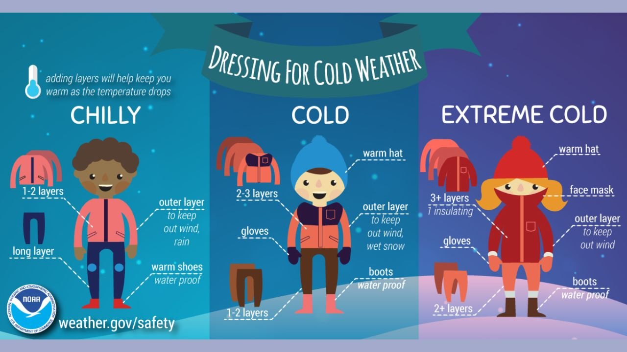
Officials Urge Residents to Dress for Extreme Cold
Weather safety guidance emphasizes the importance of layering clothing to protect against the cold. For tonight’s conditions, experts recommend:
- Multiple insulating layers, including a thick outer coat
- Hats, gloves, and face coverings to reduce heat loss
- Waterproof boots and shoes to prevent exposure from snow and ice
Even brief exposure without adequate clothing can lead to hypothermia in these conditions, especially in areas experiencing subzero wind chills.
Cold Snap Expected to Persist Into Early Wednesday
While the worst of the cold is expected overnight, dangerously low temperatures will linger into the early morning hours, particularly in rural and mountainous areas. Residents are encouraged to check on elderly neighbors, young children, and anyone without reliable heat, and to ensure pets are brought indoors.
Travelers and commuters should allow extra time Wednesday morning and remain alert for icy conditions that may persist until temperatures rise later in the day.
WaldronNews.com will continue to monitor conditions across the region and provide updates as this cold snap evolves. Residents are encouraged to stay informed, stay warm, and prioritize safety during this period of extreme winter weather.