
Southern Alabama Finally Gets the Soaking Rain It Desperately Needed as a Large Storm System Covers the Southern Two Thirds of the State This Evening
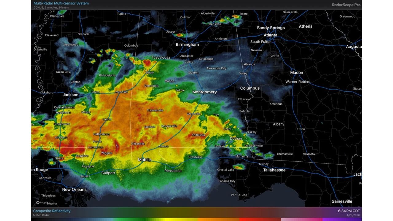
MONTGOMERY, Alabama — A large and widespread mass of rain is moving across the southern two thirds of Alabama this Wednesday evening, April 29, 2026, and for once the headline is not about danger it is about relief. The radar at 6:34 PM CDT shows heavy precipitation covering a massive footprint from Tuscaloosa and Birmingham in the north down through Montgomery, Mobile, and Dothan, with embedded thunderstorms within the broader rain mass. Severe storm risk is low and there are no active warnings anywhere in Alabama as of 6:35 PM. This is simply a parched state finally getting a drink.
Every Alabama City Currently Under the Rain Shield
The radar image shows one of the broadest single rain events to cover Alabama in recent months. The coverage is not spotty or scattered — it is a continuous, organized mass of precipitation pushing across the state ahead of a surface front.
| City | Region | Rain Intensity on Radar |
|---|---|---|
| Tuscaloosa | Central Alabama | Heavy — red/orange core |
| Selma | Central Alabama | Heavy — red/orange core |
| Thomasville | Southwest Alabama | Heavy — orange zone |
| Greenville | Central Alabama | Moderate to heavy |
| Demopolis | West Alabama | Moderate to heavy |
| Montgomery | Central Alabama | Moderate — yellow/green |
| Mobile | South Alabama | Moderate — yellow/green |
| Dothan | Southeast Alabama | Light to moderate — green |
| Andalusia | South Alabama | Moderate — yellow zone |
| Atmore | Southwest Alabama | Moderate — yellow zone |
| Citronelle | Southwest Alabama | Moderate — yellow zone |
| Pensacola | Florida Panhandle | Light — eastern fringe |
| Hattiesburg | Mississippi | Heavy — western edge |
| Gulfport | Mississippi | Moderate — Gulf Coast |
The deepest red returns — indicating the most intense rainfall rates — are concentrated in a band running from Hattiesburg, Mississippi eastward through Thomasville and Selma into central Alabama. This is where hourly rainfall rates are highest and where localized street flooding is most possible simply due to rainfall volume, not severe weather.
Why This Rain Matters So Much More Than a Typical Storm
Alabama has been dry. Not inconveniently dry — genuinely parched in a way that affects agriculture, water levels, and fire risk across the state. A rain event of this coverage and intensity arriving without a severe weather threat attached to it is as close to an ideal scenario as a drought-stressed state can hope for on a Wednesday evening in late April.
| Context | Detail |
|---|---|
| Severe storm risk tonight | Low — no warnings issued as of 6:35 PM CDT |
| Rain type | Widespread, organized — not hit-or-miss scattered storms |
| Coverage | Southern two thirds of Alabama — broad and continuous |
| Embedded thunderstorms | Present but not producing warnings |
| Primary benefit | Drought relief — beneficial soil moisture recharge |
| Surface front | Present — acting as the organizational mechanism for rain |
The surface front pushing through Alabama tonight is doing exactly what a well-behaved spring front should do — organizing rain across a large area without triggering the severe weather that so often accompanies frontal passages in April. The result is steady, meaningful precipitation soaking into ground that has been waiting for it.
🌧️ What the Radar Colors Actually Mean Tonight
For residents watching radar apps and wondering what the colors mean for their neighborhood, here is a straightforward breakdown of what each return indicates for tonight’s event specifically.
| Radar Color | Rainfall Rate | What to Expect |
|---|---|---|
| Dark red | Very heavy — 1 to 2 inches per hour | Street flooding possible in low areas — stay off roads |
| Orange | Heavy — 0.5 to 1 inch per hour | Significant rainfall — reduced visibility while driving |
| Yellow | Moderate — 0.25 to 0.5 inch per hour | Steady rain — wipers on high, slow down |
| Green | Light to moderate — under 0.25 inch per hour | Normal rain — drive carefully |
| Blue/light green | Very light — sprinkles to drizzle | Minimal impact |
The dark red core currently sitting over the Hattiesburg to Thomasville to Selma corridor means those areas are receiving the most intense rainfall tonight and brief street flooding in low-lying areas is the main concern — not tornadoes, not large hail, not damaging wind.
Why No Warnings Does Not Mean No Awareness
The absence of severe thunderstorm warnings and tornado warnings across Alabama tonight is genuinely good news. But a few practical points remain worth noting for anyone driving or outdoors across the southern half of the state.
Embedded thunderstorms within a large rain mass can still produce locally intense rainfall rates, frequent lightning, and gusty winds even without reaching the threshold for a severe warning. The orange and red cores on tonight’s radar represent rainfall rates intense enough to cause rapid standing water on roads, particularly in urban areas like Mobile and Montgomery where storm drains can become overwhelmed during heavy downpours.
The bigger driving concern tonight is visibility. A large, continuous rain mass of this size reduces visibility across hundreds of miles of Alabama roadway simultaneously. Anyone traveling on Interstate 65 between Montgomery and Mobile or on Highway 80 through Selma and Demopolis should slow down, use headlights, and give extra following distance throughout the evening hours.
What to Watch Through the Rest of Tonight
- The rain mass continues pushing eastward through the evening — Dothan and the southeast Alabama corner will see coverage increase through 8 to 9 PM as the system tracks east
- Birmingham and north Alabama are on the northern fringe — the heaviest rain stays south of the city but some coverage is possible along the I-20 corridor
- Pensacola and the Florida Panhandle catch the eastern edge of the rain shield as it exits Alabama overnight
- The front pushes through and clears most of Alabama by early Thursday morning — a brief period of clearing before the next weather question mark develops later in the week
- Rainfall totals across the Selma to Thomasville to Greenville corridor could reach 1 to 2 inches or more by the time the system exits — a meaningful deposit for drought-stressed soils
Southern Alabama needed this rain badly. Tonight it is getting it and without the severe weather price tag that so often comes attached.
WaldronNews.com will continue tracking tonight’s rain event across Alabama and provide updates as the system pushes east through the Florida Panhandle and final rainfall totals come into focus Thursday morning.