
Three Days of Relentless Severe Weather From April 27 Through 29 Produced Thousands of Severe Storm Warnings and Hundreds of Tornado Warnings Across the Midwest and Deep South
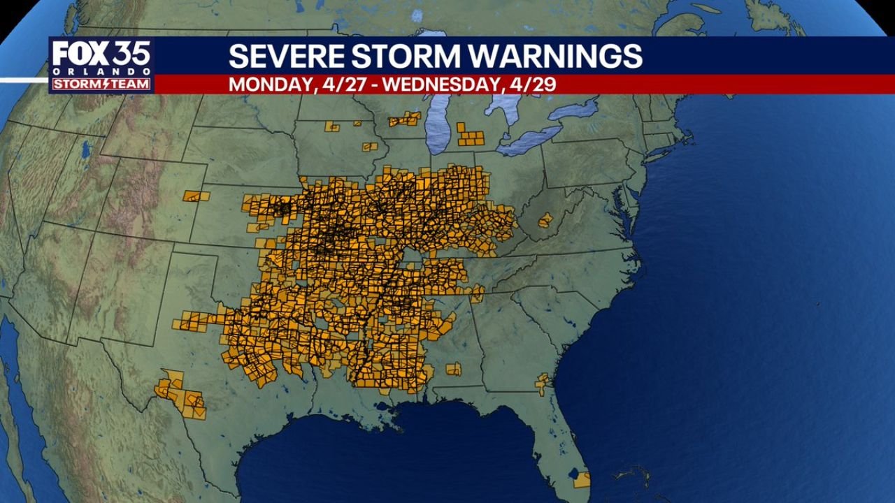
NASHVILLE, Tennessee — The three-day stretch from Monday April 27 through Wednesday April 29, 2026 has been one of the most prolific severe weather outbreaks of the spring season, producing thousands of severe thunderstorm warnings and hundreds of tornado warnings across a massive footprint stretching from the southern Plains through the Midwest and Deep South. The warning maps tell the story visually in a way that is difficult to fully absorb. Orange counties stacked on orange counties from Texas to Ohio, and red tornado warning boxes clustered so densely across Kansas, Oklahoma, Missouri, Arkansas, and Tennessee that individual counties are nearly impossible to distinguish. This was not a one-day event. It was three consecutive days of life-threatening weather across the central United States.
How Three Days of Warnings Stacked Up Across the Country
The severe storm warning footprint covers an extraordinary geographic area. The orange warning map shows counties from western Texas and Oklahoma all the way northeast through Missouri, Illinois, Indiana, Kentucky, Tennessee, and Mississippi. Essentially the entire central corridor of the country received severe thunderstorm warnings at some point between Monday and Wednesday.
| Warning Type | Geographic Footprint | Density |
|---|---|---|
| Severe Thunderstorm Warnings | Texas northeast through Ohio and Indiana | Thousands, nearly continuous coverage |
| Tornado Warnings | Kansas, Oklahoma, Missouri, Arkansas, Tennessee, Mississippi | Hundreds, densely clustered red boxes |
| Isolated severe warnings | Great Lakes, Michigan, Wisconsin | Scattered outliers north of main corridor |
| Gulf Coast warnings | Louisiana, southern Mississippi, Alabama | Active Wednesday as system pushed south |
The tornado warning map is particularly striking. The red boxes are not scattered randomly. They cluster in distinct corridors that reveal exactly where the most dangerous rotating storms tracked across the three days. The heaviest tornado warning concentration sits over Kansas, Oklahoma, and Missouri on the western end, with a second dense cluster running through Arkansas, Tennessee, and northern Mississippi on the eastern side.
The Geographic Shift That Defined This Outbreak
One of the most significant stories within this three-day outbreak is not just its size. It is where it happened compared to the rest of April.
| Comparison | Detail |
|---|---|
| Most of April severe weather | Focused primarily on the central and northern Plains |
| April 27 through 29 outbreak | Shifted notably southward into the Deep South and southern Midwest |
| States most affected this week | Oklahoma, Arkansas, Tennessee, Mississippi, Alabama |
| States less active than typical April | Northern Plains, upper Midwest |
| Early May outlook | Continued southward shift before a mid-month quiet period |
| Late May outlook | Severe weather trends back toward the Plains |
This southward shift matters because it changes which communities need to be on alert. States like Tennessee, Mississippi, and Alabama that can sometimes sit on the periphery of major outbreaks were directly in the core of this one, and that pattern appears likely to continue into early May before the pattern eventually quiets down mid-month.
What Thousands of Warnings in Three Days Actually Means
Numbers like thousands of severe storm warnings can feel abstract. Here is what they represent on the ground.
| Metric | What It Means for Real People |
|---|---|
| Thousands of severe thunderstorm warnings | Each warning covers one or more counties and represents a storm confirmed to produce 58 mph or higher winds or 1 inch hail |
| Hundreds of tornado warnings | Each warning represents a confirmed rotating storm or radar-indicated tornado |
| Dense warning clustering over Kansas and Oklahoma | These states saw the most intense and repeated tornado-capable storm activity |
| Warning footprint reaching Ohio and Indiana | The outbreak was not confined to traditional tornado alley |
| Gulf Coast warnings on Wednesday | The system remained capable of producing severe weather all the way to the Louisiana and Alabama coast |
States That Took the Hardest Hit From Monday Through Wednesday
| State | Role in the Outbreak |
|---|---|
| Kansas | Western anchor of tornado warning cluster, repeated rotating storm activity |
| Oklahoma | Core tornado warning zone, among the densest red box coverage on the map |
| Missouri | Transition zone, heavy severe thunderstorm and tornado warning coverage |
| Arkansas | Eastern tornado warning cluster, significant rotating storm activity |
| Tennessee | Eastern severe corridor, tornado and severe thunderstorm warnings both active |
| Mississippi | Southern extension, warnings active all three days including Wednesday |
| Texas | Western severe thunderstorm warning footprint, storms active Monday and Tuesday |
| Illinois | Northern fringe of main corridor, heavy severe thunderstorm warning coverage |
| Indiana | Northeastern edge, severe thunderstorm warnings reached into the state |
| Alabama | Wednesday severe thunderstorm watch and warnings, active into Wednesday evening |
What the Pattern Looks Like From Here Through Late May
The three-day outbreak is ending but the broader severe weather season is not entering a quiet phase. It is shifting.
Early May will continue to see the southward shift in severe weather activity that defined this outbreak. The Deep South states including Louisiana, Mississippi, Alabama, Tennessee, and Arkansas remain more in focus than the northern Plains for the first week or two of May. Mid-May appears likely to bring a genuine break in organized severe weather activity as an upper air pattern change settles in and suppresses the most explosive setups. Then late May brings the return of severe weather focus back toward the Plains, with Kansas, Oklahoma, Nebraska, and Texas back in the crosshairs as the seasonal pattern shifts again.
What to Watch Going Into Early May
- Tornado warning activity across Arkansas, Tennessee, and Mississippi as the southward shift continues. These states are not done with severe weather just because the April 27 to 29 outbreak is wrapping up.
- Whether the mid-May quiet period verifies. If the upper air pattern change does not materialize as expected, the break may be shorter or less pronounced than currently anticipated.
- Damage survey results from the three-day outbreak. The density of tornado warnings across Kansas, Oklahoma, and Missouri over three days means confirmed tornado tracks and EF ratings will be coming in from survey teams over the next several days.
- Late May Plains ramp-up. If the pattern shifts back toward Kansas and Oklahoma as expected in the final week of May, it will arrive into an atmosphere that has been active and primed throughout the month.
- The cumulative impact on communities hit on multiple consecutive days. Back-to-back tornado warnings on back-to-back days represent a compounding threat more dangerous than any single outbreak.
WaldronNews.com will continue tracking the aftermath of the April 27 through 29 severe weather outbreak and provide updates on damage surveys, confirmed tornadoes, and the evolving pattern heading into early May.