
Charlotte and Western North Carolina Stay Mostly Dry This Saturday as Coastal Low Keeps Heavy Rain Locked to the East While Temperatures Settle Into the 50s and Low 60s
CHARLOTTE, North Carolina — Residents across the Charlotte metro and western North Carolina can set aside concerns about a soaking weekend. The low pressure system driving rain along the Eastern Seaboard this Saturday is hugging the coast tightly, and that positioning keeps the heaviest rainfall well east of Charlotte and inland North Carolina. What Charlotte actually gets is mist, drizzle, and chilly temperatures sitting in the 50s to low 60s rather than any meaningful rainfall. The futurecast rainfall map valid Saturday by 5:00 PM tells the story precisely, with Charlotte sitting at just .03 to .04 inches for the entire day while coastal communities rack up significantly higher totals.
Exactly How Much Rain Each City Gets This Saturday
The rainfall forecast map is the most important data point for this weekend and it draws a clear dividing line between the dry west and the wet east.
| City | State | Forecast Rainfall by 5 PM Saturday |
|---|---|---|
| Boone | North Carolina | 0.00 inches |
| Jefferson | North Carolina | 0.00 inches |
| Mount Airy | North Carolina | 0.00 inches |
| Morganton | North Carolina | 0.00 inches |
| Hickory | North Carolina | 0.00 inches |
| Statesville | North Carolina | 0.01 inches |
| Salisbury | North Carolina | 0.01 inches |
| Lincolnton | North Carolina | 0.01 inches |
| Asheville | North Carolina | 0.01 inches |
| Gastonia | North Carolina | 0.04 inches |
| Charlotte | North Carolina | 0.03 inches |
| Rock Hill | South Carolina | 0.08 inches |
| Monroe | North Carolina | 0.06 inches |
| Concord | North Carolina | 0.02 inches |
| Albemarle | North Carolina | 0.02 inches |
| Chester | South Carolina | 0.11 inches |
| Lancaster | South Carolina | 0.15 inches |
| Cheraw | South Carolina | 0.20 inches |
| Wadesboro | North Carolina | 0.09 inches |
| Rockingham | North Carolina | 0.16 inches |
| Pinehurst and Southern Pines | North Carolina | 0.08 inches |
| Fayetteville | North Carolina | 0.29 inches |
| Raleigh | North Carolina | 0.02 inches |
| Greensboro | North Carolina | 0.01 inches |
The gradient is unmistakable. From Boone and Hickory with zero measurable rainfall all the way down to Fayetteville at 0.29 inches and Cheraw at 0.20 inches, the rain increases steadily as you move southeast toward the coast. Charlotte at 0.03 inches barely qualifies as drizzle.
Why Charlotte Stays Dry While the Coast Gets Soaked
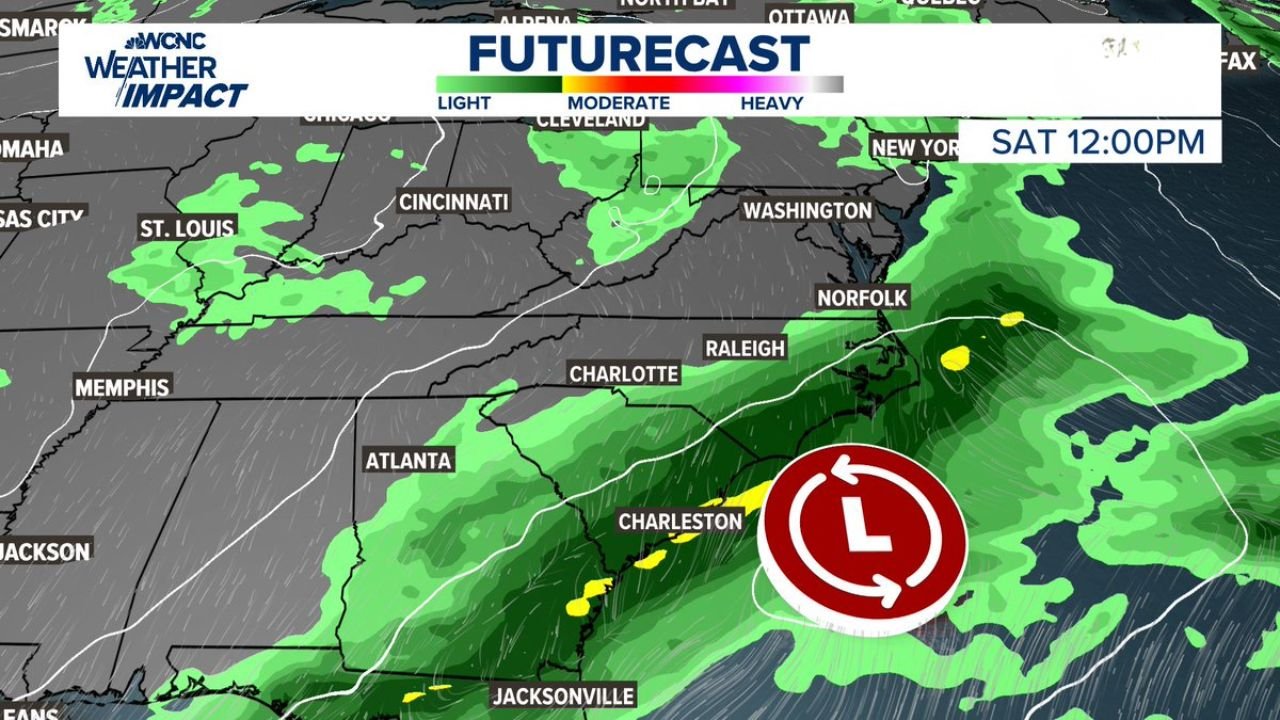
The entire story this weekend comes down to where the low pressure center is positioned. The futurecast map valid Saturday at noon shows the low pressure symbol sitting offshore near Charleston, South Carolina, well east of the Appalachians. Low pressure systems pull their heaviest rainfall toward their center and just to the north and northeast of that center. With the low parked near the South Carolina coast, the moisture tap runs directly along the coastal plain from Jacksonville, Florida up through Charleston and Norfolk, Virginia.
Charlotte sits too far inland and too far west to tap into that moisture effectively. The mountains of western North Carolina act as an additional barrier, squeezing out what little moisture tries to push inland and leaving communities from Asheville to Boone to Hickory almost completely dry.
🌡️ What Charlotte and the Region Actually Experience Saturday
| Detail | What to Expect |
|---|---|
| Charlotte rainfall | 0.03 inches, drizzle and mist only |
| Charlotte temperature at 10 AM | 58 to 59 degrees |
| Western mountains temperature | 49 degrees in Boone, 50 degrees in Bristol |
| Piedmont temperatures | 57 to 61 degrees across most cities |
| Sky condition | Gray, overcast, chilly feel |
| Severe weather risk | None |
| Best description | A raw, gray, cool May Saturday indoors kind of day |
Boone sitting at 49 degrees Saturday morning is a reminder that despite this being early May, the overcast skies and lack of sunshine will keep mountain communities genuinely cold throughout the day. Anyone heading to the mountains for the weekend should pack layers.
The Dry West Versus Wet East Split in Plain Terms
Saturday is essentially two completely different weather days happening simultaneously across North Carolina and South Carolina, separated by about 100 miles.
West of Charlotte, from Asheville through Hickory and up into Boone, Saturday is a gray and cool day with no rain worth mentioning. Outdoor plans are not washed out by rain but are dampened by the overcast and chilly feel. Temperatures in the upper 50s and low 60s with mist mean a jacket is necessary but an umbrella is optional.
East and southeast of Charlotte, the story shifts quickly. By the time you reach Fayetteville, Cheraw, and Rockingham, Saturday delivers measurable and noticeable rainfall as the moisture from the coastal low begins to reach inland. Communities along and east of Highway 74 will feel a genuinely wet Saturday afternoon while Charlotte residents barely notice any rain at all.
What to Watch Through the Weekend
- Whether the low pressure system drifts slightly inland Saturday evening, which would push the rain shield a bit further west toward Charlotte and Concord during the late afternoon hours
- Sunday clearing timeline as the coastal low tracks northeast and the moisture feed diminishes across the Carolinas
- Mountain road conditions around Boone and the Blue Ridge Parkway where the combination of 49 degree temperatures and overcast skies could create slick spots on elevated roads and shaded curves Saturday morning
- The next rainfall opportunity for Charlotte and inland North Carolina, which has struggled to find substantial rainfall beyond isolated events in recent weeks
- Temperatures rebounding through the first half of next week as the coastal system clears and more typical early May warmth returns to the Piedmont
Charlotte residents frustrated by the lack of meaningful rainfall this season will not find relief this weekend. The coast gets the rain and the Piedmont gets the clouds.
WaldronNews.com will continue tracking the coastal low pressure system and provide updates on rainfall totals and clearing timing across North Carolina and South Carolina through the weekend.