
Washington D.C. Region Stays in Severe Drought Despite Wednesday Rain
WASHINGTON, D.C. — Wednesday’s rain across the D.C. metro brought the most meaningful precipitation the region had seen since April 5, but it was not nearly enough to make a dent in the Severe Drought that now blankets the entire Washington, D.C., Maryland, and Virginia region. The Drought Monitor released Thursday April 30 shows D2 Severe Drought covering virtually the entire area, with a pocket of D3 Extreme Drought appearing in southern Virginia. The uncomfortable truth behind the numbers is that much of the region is running a rainfall deficit of 2 to 4 inches below normal since March 1, and Wednesday’s rain of a half inch in the best spots and less than 0.25 inches in southern and eastern areas barely scratches the surface of what is needed.
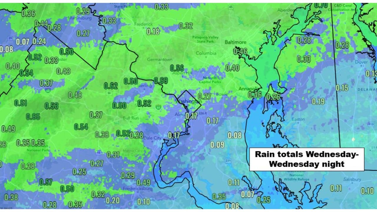
Exactly How Much Rain Fell Wednesday and Why It Was Not Enough
The rainfall map from Wednesday into Wednesday night shows a clear split across the region, with the northwest suburbs doing best and the areas south and east of Washington receiving far less.
| Location | Wednesday Rainfall Total |
|---|---|
| Sterling, Virginia | 0.69 inches |
| Aspen Hill, Maryland | 0.56 inches |
| Martinsburg, West Virginia | 0.29 to 0.33 inches |
| Frederick, Maryland | 0.18 inches |
| Germantown, Maryland | 0.50 inches |
| Bull Run area, Virginia | 0.50 to 0.54 inches |
| Dale City, Virginia | 0.28 to 0.31 inches |
| Washington D.C. | 0.17 inches |
| Alexandria, Virginia | 0.17 inches |
| Bowie, Maryland | 0.17 inches |
| Baltimore, Maryland | 0.40 to 0.46 inches |
| Annapolis, Maryland | 0.26 to 0.46 inches |
| Fredericksburg, Virginia | 0.29 to 0.49 inches |
| Easton, Maryland | 0.15 to 0.19 inches |
| Salisbury, Maryland | 0.10 to 0.11 inches |
| Dover, Delaware | 0.13 inches |
Sterling and the northern Virginia suburbs did the best with nearly 0.69 inches, which represents the high end of meaningful rain for a single event. But Washington itself received only 0.17 inches and areas south and east of the city fell well below even that. For context, the region needs somewhere between 2 and 4 additional inches above normal rainfall just to recover from the deficit that has built since March 1. One event delivering a quarter inch to half an inch in most spots does not move that needle in any significant way.
What the Drought Monitor Released Thursday Actually Shows
The Drought Monitor map released Thursday April 30 is stark. There is almost no part of Maryland, Virginia, or the D.C. region that is not inside the D2 Severe Drought classification. The orange color dominates the entire map from the West Virginia border eastward through every county in Maryland and Virginia to the Chesapeake Bay.
| Drought Category | Coverage | What It Means |
|---|---|---|
| D0 Abnormally Dry | Small fringe in northern Maryland | Rainfall is below normal but no drought yet |
| D1 Moderate Drought | Minimal coverage | Streamflows and soil moisture notably low |
| D2 Severe Drought | Covers virtually the entire region | Crop losses likely, water restrictions possible, streams very low |
| D3 Extreme Drought | Southern Virginia pocket | Widespread crop and pasture losses, water shortages developing |
| D4 Exceptional Drought | Not present yet | Reserved for worst possible conditions |
The D3 Extreme Drought pocket in southern Virginia is the most alarming detail on the map. That classification indicates conditions severe enough to cause widespread crop failures and the beginning of genuine water supply concerns for affected communities.
🌧️ How Big Is the Rainfall Hole the Region Needs to Fill
This is the number that puts everything in perspective.
| Metric | Detail |
|---|---|
| Rainfall deficit since March 1 | 2 to 4 inches below normal across most of the region |
| Last meaningful rain before Wednesday | April 5, more than three weeks prior |
| Wednesday best case rainfall | 0.69 inches in Sterling, Virginia |
| Wednesday worst case rainfall | 0.07 to 0.09 inches south and east of D.C. |
| Rain needed to end Severe Drought | Multiple inches above normal over several weeks |
| Impact of Wednesday rain on drought status | Not enough to change the Drought Monitor classification |
The Drought Monitor report released Thursday only factors in rainfall through Tuesday, meaning Wednesday’s rain is not yet reflected in the official drought classifications shown on the map. Even accounting for what fell Wednesday, the math does not work in the region’s favor. A half inch against a two to four inch deficit leaves the hole largely unfilled.
Why Severe Drought in May Matters More Than Severe Drought in Winter
A D2 Severe Drought classification in January is damaging. The same classification arriving in May is significantly more dangerous for several reasons that directly affect daily life across the D.C. region.
May is when lawns, gardens, crops, and trees are entering their peak growing season and demanding the most water from the soil. Reservoirs and streams that enter May already depleted from a dry March and April have no buffer against the heat and evaporation that summer brings. The Chesapeake Bay watershed, which depends on spring rainfall to flush nutrients and maintain water quality, enters summer already stressed. And water demand from households, businesses, and agriculture spikes precisely when the supply is most constrained.
Southern Virginia sitting in D3 Extreme Drought heading into May means farmers in that region face a genuinely difficult growing season unless significant and repeated rainfall arrives soon.
What to Watch for the Region Going Forward
- Whether any meaningful rain systems target the D.C. corridor in the first two weeks of May. The pattern heading into early May does not strongly favor repeated soaking rains for the mid-Atlantic region.
- Water restriction announcements from municipal water authorities across northern Virginia and Maryland as reservoir levels reflect the prolonged dry stretch since March 1.
- The next Drought Monitor update, which will factor in Wednesday’s rainfall and may show slight improvement in the northwestern suburbs around Sterling and Germantown while the areas south and east of Washington remain unchanged.
- D3 Extreme Drought expansion in southern Virginia if May continues dry. The southern Virginia pocket currently classified as extreme drought is the area most at risk of worsening further if rainfall remains scarce.
- Any pattern shift in mid to late May that could bring more organized and widespread rainfall back to the mid-Atlantic states after the early May pattern appears likely to stay relatively dry.
A half inch of rain on a Wednesday in late April is welcome. It is just nowhere near enough for a region carrying a two to four inch deficit and sitting squarely inside Severe Drought territory heading into the warmest months of the year.
WaldronNews.com will continue tracking drought conditions across Washington D.C., Maryland, and Virginia and provide updates as the Drought Monitor releases new classifications and rainfall opportunities develop across the region.