
Wyoming, Washington, Oregon, Montana, and Colorado See Hurricane-Force Wind Gusts as Powerful Western Storm Unleashes Extreme Conditions
WYOMING — A powerful and unusually intense storm system tore across the western United States this week, producing hurricane-force wind gusts across high-elevation and mountain locations in Wyoming, Washington, Oregon, Montana, and Colorado, with some gusts rivaling those seen in Category 3 and Category 4 hurricanes.
According to compiled observations and regional weather data, the strongest winds were concentrated in mountainous terrain, where exposed ridges and peaks experienced extreme atmospheric pressure gradients and jet-stream support.
Hurricane-Force Wind Gusts Recorded Across the West
Several official and high-confidence observations show just how intense this wind event became:
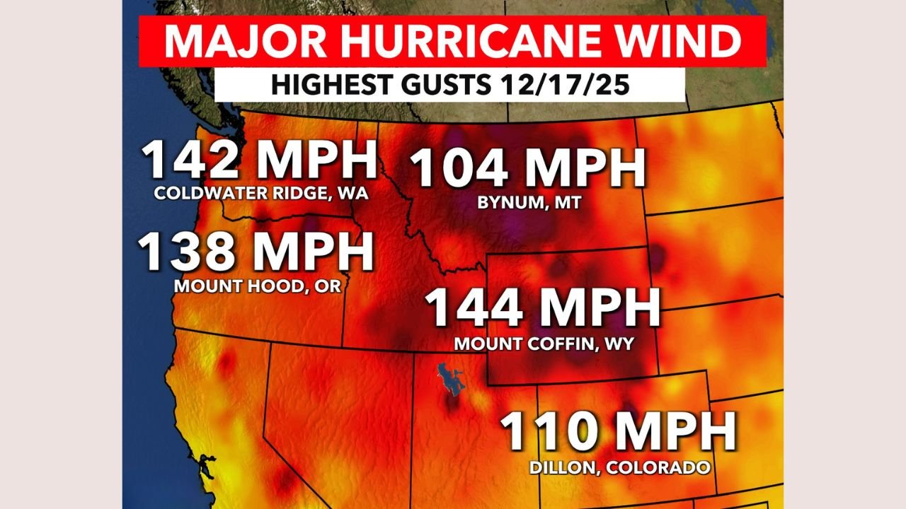
- Mount Coffin, Wyoming: 144 mph wind gust
- Coldwater Ridge, Washington: 142 mph wind gust
- Mount Hood, Oregon: 138 mph wind gust
- Dillon, Colorado: 110 mph wind gust
- Bynum, Montana: 104 mph wind gust
“These wind speeds are comparable to a major hurricane,” meteorologists noted, emphasizing that most of the strongest readings occurred at high elevations, where wind speeds can dramatically exceed those in valleys and urban areas.
Why the Winds Became So Extreme
The extreme winds were driven by a powerful upper-level jet stream interacting with a strong surface pressure gradient across the western states. As the storm intensified, fast-moving air aloft mixed down to the surface, particularly over mountain ridges and passes.
Key contributing factors included:
- A strong Pacific storm system moving inland
- Tight pressure gradients between low- and high-pressure systems
- Enhanced wind acceleration over exposed terrain
- Cold air aloft increasing atmospheric instability
This setup allowed winds to reach levels rarely observed outside of tropical cyclones, even though this was a non-tropical storm.
Impacts Focused on Mountain and High-Elevation Areas
While most populated valleys and cities experienced much lower wind speeds, the impacts in mountain regions were significant. High winds of this magnitude can lead to:
- Dangerous travel conditions on mountain highways
- Structural damage to towers, antennas, and exposed buildings
- Downed trees and power lines
- Severe wind chill and whiteout conditions when combined with snow
Weather officials stressed that these conditions can be life-threatening for anyone caught outdoors in exposed locations.
How Rare Is This Kind of Wind Event?
Wind gusts exceeding 130 mph are uncommon outside of hurricanes and the most intense mountain windstorms. Events like this are typically confined to isolated peaks, but the number of locations reporting triple-digit gusts makes this storm particularly notable.
One meteorologist described the event as “an extreme but well-forecast example of how powerful winter storms in the West can become.”
What Happens Next
As the storm system continues eastward and weakens, wind speeds across the western states are expected to gradually decrease. However, forecasters caution that additional strong storms remain possible later this winter, especially during periods of active Pacific weather patterns.
Residents and travelers in mountain regions are urged to monitor local forecasts closely, especially when high-wind warnings are issued.
WaldronNews.com will continue tracking major weather events across the country and providing clear, reliable updates. If you experienced extreme winds or storm impacts in your area, share your experience and stay informed with the latest forecasts through WaldronNews.com.