
Washington State Faces Another Strong Westerly Wind Surge Along Strait of Juan de Fuca as HRRR Signals Gusts Over 65 mph
WASHINGTON — Parts of western Washington are preparing for another round of powerful winds Friday afternoon and evening, as forecast models indicate a renewed westerly surge pushing through the Strait of Juan de Fuca while a strengthening Pacific storm moves inland.
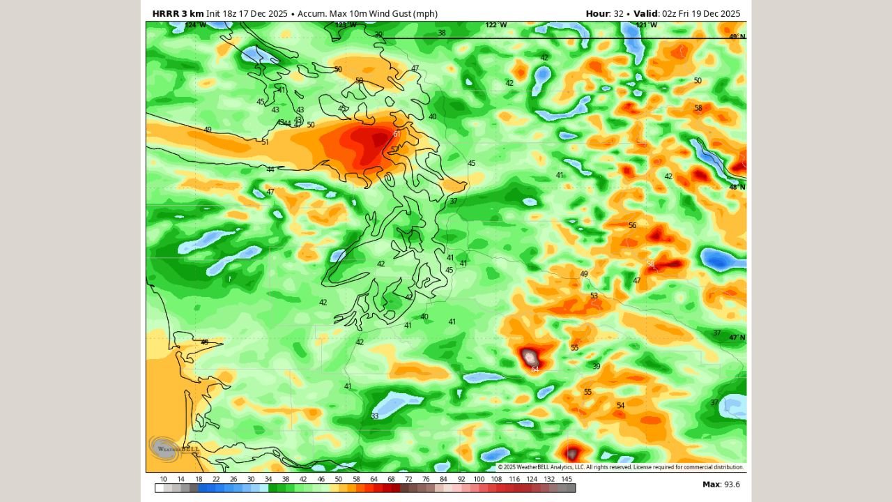
Latest high-resolution guidance, including the HRRR model, shows a setup similar to the impactful wind event observed the previous night, though meteorologists caution this next surge may pack slightly less overall intensity. Even so, localized damaging wind gusts remain a concern, particularly for communities exposed to westerly flow.
Strongest Winds Focused on the Strait of Juan de Fuca
Forecast imagery highlights the highest wind potential along the Strait of Juan de Fuca, where channeling effects frequently enhance wind speeds. According to model projections:
- Gusts exceeding 65 mph are possible from Port Townsend to Oak Harbor
- Exposed coastal headlands and marine zones may briefly see higher localized gusts
- Wind speeds are expected to increase rapidly during the late afternoon into early evening, roughly between 4 p.m. and 6 p.m.
While the HRRR may be slightly aggressive, forecasters note it performed remarkably well during the previous night’s wind surge, lending added confidence to the signal.
Broader Western Washington Impacts
Outside the core wind corridor, much of western Washington is still expected to experience gusty and potentially disruptive conditions.
- Most lowland areas could see gusts in the 35–50 mph range
- Higher terrain and gap-enhanced locations may briefly exceed those values
- Urban areas including parts of Puget Sound could experience scattered tree damage and power disruptions
The wind field shown in the latest model runs indicates a widespread event, even if the most severe impacts remain confined to favored locations.
Why This Setup Matters
This event is driven by a tight pressure gradient and strong westerly flow behind a Pacific system intensifying as it moves inland. The orientation of the Strait of Juan de Fuca makes it particularly vulnerable to these setups, often resulting in sudden, high-end gusts that can exceed typical wind forecasts.
Forecasters are closely monitoring whether later model runs maintain or reduce the projected intensity, especially given the HRRR’s tendency to occasionally overdo peak gusts. Still, confidence is high enough to warrant heightened awareness across western Washington.
Safety and Preparedness Reminders
Residents are urged to remain cautious during the peak wind window:
- Secure loose outdoor items
- Be alert for falling tree branches and flying debris
- Use extra caution if traveling, especially in high-profile vehicles
- Prepare for the possibility of isolated power outages
Conditions will continue to be monitored closely as additional model updates arrive.
For ongoing weather updates, impact tracking, and local coverage, stay connected with WaldronNews.com and check back as this evolving situation develops.